All Activity
- Past hour
-
Not the best night for a light snowfall. Hopefully people drive safely
-

Pittsburgh/Western PA WINTER ‘25/‘26
SteelCity87 replied to Burghblizz's topic in Upstate New York/Pennsylvania
Still noticing some mixing driving through Kennedy. -
I am not convinced of the correlation between phase 6 and cold. What I think is occurring is QBO induced HL blocking(in some cases) is simply prevent the MJO signal from having influence over NA. I think the MJO has a much bigger impact when HL blocking is absent. As Cosgrove noted, the best thing we can do is simply look at the vortices lined-up which are approaching the US. You can kind of see the stormier patterns and deduce timing of such. Use analogs to fish out a good 500 pattern in addition to wx models. That is more accurate than relying on simply teleconnections which I am always guilty of...
-

Pittsburgh/Western PA WINTER ‘25/‘26
TheClimateChanger replied to Burghblizz's topic in Upstate New York/Pennsylvania
Snowing here, although it is a grainier snow, not the fluff from earlier. -

New Years Day 2026 - 1st snows of the new year possible
SJonesWX replied to Baroclinic Zone's topic in New England
what, you couldn’t find a .gif with humping wolves? -

Pittsburgh/Western PA WINTER ‘25/‘26
colonel717 replied to Burghblizz's topic in Upstate New York/Pennsylvania
Hmmm...Just flakes here -
NY and PA snow crews are some of the best.
-
Another thing - if you actually live there, LES becomes a stress because you really need to keep your roof cleared off so it doesn't collapse. When you're a kid it's cool, but once you get older you start to worry about the roof on your older home. And snow invariably seemed to blow into the attic and cause water issues in the ceiling.
-
New Years Day 2026 - 1st snows of the new year possible
KTBFFH1905 replied to Baroclinic Zone's topic in New England
Same here. I love the ambiance of it. I keep a small fake one up in my little basement bunker room. -
So, when I look at that. I see an East African/IO wave working from 1-2 to 4-5 and then to 6(and then fizzling out). I also see some convection at the dateline which is phase 8. Looks like the phase 6 dies out. In my mind, that would correspond to the warm waves prior to the 12th per lagged composites? Looks pretty weakfish to me in general with 2-3 strong days in 6. I think HL blocking eventually trumps it unless it holds onto that stronger look for more than 2-3 days.
-

Pittsburgh/Western PA WINTER ‘25/‘26
TimB replied to Burghblizz's topic in Upstate New York/Pennsylvania
Looks like that freezing drizzle at the airport has since changed over to all snow. -

12/31-1/1 Possible Snow Showers/Squalls to Start 2026
IronTy replied to bncho's topic in Mid Atlantic
I can't believe I missed it by a couple days. There better still be some snow at the end of January. -
Snow when I went to Syracuse wasn’t nearly as much fun as snow down here. With snow being rare down here every event is special. In places like Syracuse several inches of snow is just par for the course and life goes on normally. I’m as big a snow lover as you’ll find (one of the reasons I went to Syracuse) but by March I wasn’t rooting for snow anymore and was ready for spring.
-

New Years Day 2026 - 1st snows of the new year possible
WxWatcher007 replied to Baroclinic Zone's topic in New England
Hi res pulls the rug up here. Can’t get meaningful precip into the area. We’ll see if that’s real. Very light snow falling. 18.6/14 -

12/31-1/1 Possible Snow Showers/Squalls to Start 2026
nj2va replied to bncho's topic in Mid Atlantic
8-12”, gimme gimme. SN- and freezing drizzle here — got a glaze of ice. -
Pittsburgh/Western PA WINTER ‘25/‘26
TheClimateChanger replied to Burghblizz's topic in Upstate New York/Pennsylvania
The airport is reporting freezing drizzle. Hopefully that won't last long! -
Pretty good looks in my book. I used to only do long range stuff based on precip anomalies and temp anomalies. I don't think I am much better today with all of the extra stuff. Here are some Euro LR ext maps centered on d15-46. I have attached both the mean and control runs. You can see below normal temps with above normal precip(yeah, that surprised me). I actually went through and looked at the precip by 7 day increments to see if it was just one big rainer. Nope, it looks like normal precip with the exception of the first maybe ten days. BN temps, AN precip, and a solid 500 map.
-

2025-2026 ENSO
40/70 Benchmark replied to 40/70 Benchmark's topic in Weather Forecasting and Discussion
Considering the length of the 2001 (33 days) and 2018 (20) events, it as expected that a reflection event will begin between approximately January 13th and 16th 2026, and end between about February 2 and 18th. This is consistent with the climatologically favored time frame per the research that was referenced previously. In order to better understand how the PV interacts with North American weather, Lee at al identified four distinct weather regimes and listed their respective frequency of occurrence between the months of November and March, from 1979 through 2017, since they last longer than synoptic scale patterns and thus provide an opportunity for longer range prediction. Pacific Trough Pattern Precursor for Reflection Events Pattern recognition is paramount in the analysis and diagnosis of reflection events because the behavior of the polar vortex has predictive value on each of these regimes at both seasonal, and sub-seasonal leads, which is roughly 15-60 day in advance. "The PV strength significantly affects the occurrence and persistence of each regime and transition between regimes" (Lee at al 2019). Research by Kretschmer et al (2018) illustrated the importance of planetary wave reflection for anomalous cold across North America. This expounded on earlier work by Kordera et al (2016) that found that wave reflection born of Pacific blocking tele-connected to a down stream trough over North America. Thus the implication here is that the Alaskan ridge pattern, which is not at all connected to the PV and is actually accompanied by a +NAO, as alluded to earlier, is most conducive to reflection events and is this correlated to the most severe arctic outbreaks in the US. Lee et al (2019) refers to this type of pattern as the "Alaskan Ridge Regime" , which is similar to the Tropical Hemisphere Pattern (+TNH). This has been the most common vehicle for cold delivery over the past decade given the increased tendency for +NAO during the winter season, so it is important to remain mindful of the fact that climate change is certainly not prohibitive to severe cold outbreaks. It does, however, decrease residence time due to the enhanced Pacific jet keeping the flow more progressive. -
Nothing beats hometown snow. I saw 7 feet of snow in the Nov 2014 Buffalo Lake Effect event. Very cool to see, but it can’t beat 2 feet on my own turf. However, if you have not witnessed lake effect like that, it is worth the trip. .
-
When I used to live in Michigan we got sick of LES after a time. Once you got enough base to snowmobile anywhere you want to go then anything on top of that is just a hassle to find somewhere to put it. Also, knowing that it's not til May before winter really ends kinda sucks. Also, as soon as the lakes freeze over, there goes your LES. No such thing as a coastal storm up there. Or here, either it seems. Also, there's something kind of unsatisfying to be stuck in a LES band for an hour then then have it shift a couple miles and be blazing sun out. Doesn't feel right. Better than this snow desert though.
-

Pittsburgh/Western PA WINTER ‘25/‘26
Burghblizz replied to Burghblizz's topic in Upstate New York/Pennsylvania
It absolutely did here. Cars and sidewalks encased in ice. Very surprising. Not sure why as whole column would figure to be below freezing. Snowing now -
But BAM is missing with the tropical forcing,sorry but hes wrong
-
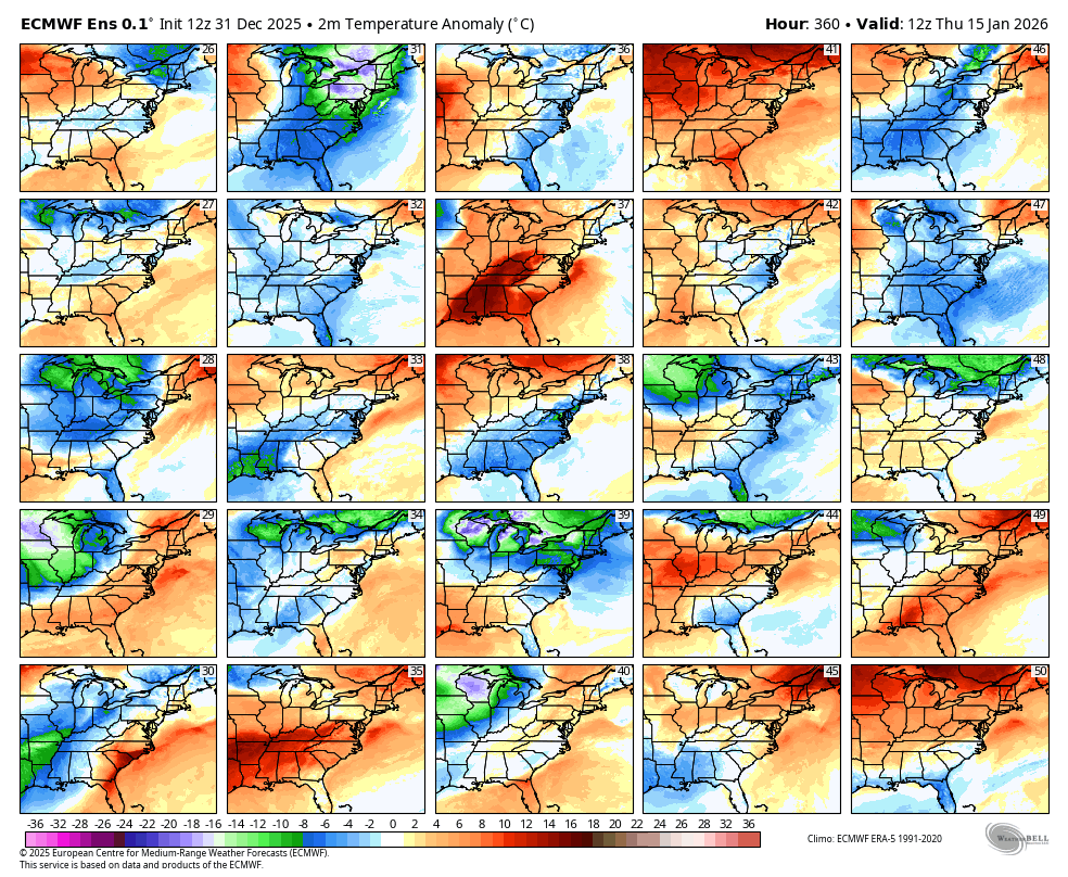
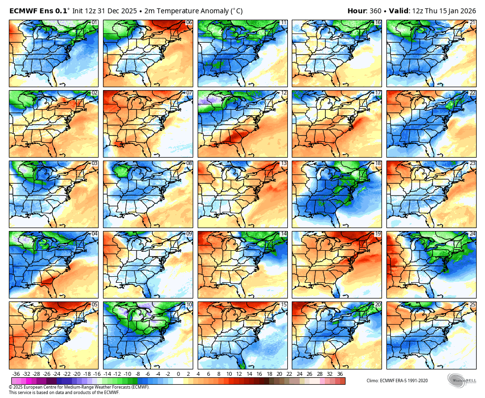
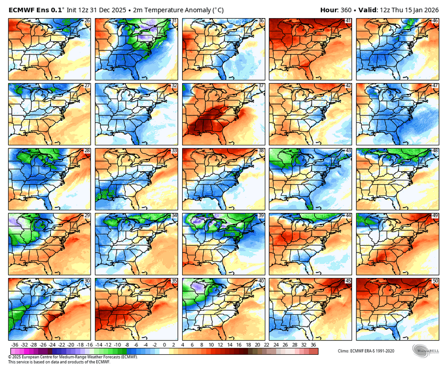
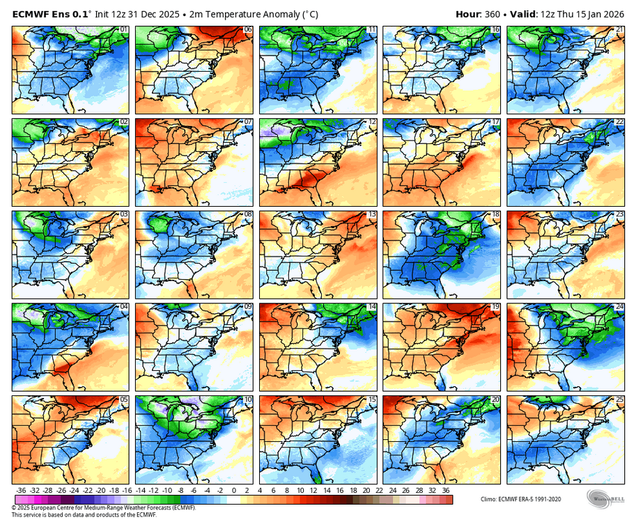
Let's test the can kicking of the models. Below are WB EPS 12Z temp panels for the 15th. Let's see which way they trend over the next two weeks.
-
2025-2026 ENSO
40/70 Benchmark replied to 40/70 Benchmark's topic in Weather Forecasting and Discussion
Perhaps these excerpts from my outlook last fall will prove somewhat illuminating.... Lee et al (2019) identified the transition from this Pacific trough regime to the Alaskan ridge regime as most conducive to the type of wave propagation needed to trigger a reflection event, which renders the Pacific trough regime the precursor pattern. This is a remarkable extended forecasting tool given the expectation for a mid January onset of a reflection event, as this implies that the first half of January is likely to be mild and characterized by Pacific trough regime with a rapidly consolidating PV, thus the arctic low regime is also worthy of consideration here during this mid-winter-thaw period. This period will also feature a considerable Pacific jet extension as mild Pacific air infiltrates the vast majority of the CONUS and flooding becomes a concern for areas that amassed a snowpack during the early season arctic high regime. Any seasonably cold air masses are likely to be dislodged from the east coast by a primary storm track across the interior. The expected midseason progression is illustrated in the schematic below that details the typical evolution of reflection event. Note that the pattern begins to reverse in earnest approximately 5 days after the event onset, during which time the anonymously strong PV reverts to normal strength, and begins to stretch due to the building Alaskan and Aleutian ridging that retrogrades from North America. This is why it very mild at the onset of these events, during the antecedent Pacific trough pattern, but by ten days post reflection the pattern has reversed and is characteristic of an Alaskan ridge regime (bottom right above). Once the process terminates and run its course by early February, a more canonical La Nina pattern will likely ensue in the absence of the expected SSW. However, should one materialize as anticipated, another arctic high interval is possible for potential grand finale to the season. -
NAM brings us a minor ice storm Saturday night