All Activity
- Past hour
-
EPS likes Dec 5-6 a lot more than Dec 2-3.
-
If I get 4-5” on Tuesday, I will bow to my AI overlords
-
There’s quite a few in here that are superstitious lol, But no reason for a thread that’s 5 +days out.
-
Keith is concerned about events thru 12/6 Hapoy Thanksgiving my man!
-

Nov 28-30th Post Turkey Day Wintry Potential
ILSNOW replied to Chicago Storm's topic in Lakes/Ohio Valley
Happy Thanksgiving to all!!!! -
Oh yea. Gimme.
-
Euro has been trending towards a more neutral, slightly negative AO/NAO after Dec 5th. Good to see.
-

December 2025 regional war/obs/disco thread
Sey-Mour Snow replied to Torch Tiger's topic in New England
It’s best to thread these when it’s obviously going to affect only one region, or there are multiple threats. For now everyone has a chance so we can keep it here. -

December 2025 regional war/obs/disco thread
Great Snow 1717 replied to Torch Tiger's topic in New England
Sunday at the earliest. I don't bother looking at model runs until within 48 hours...anything outside of that is sort of like looking through the SI Swimsuit issue and believing one of the swimsuit models is stopping by for dinner.. -
Shut up and embrace the technology!
-
If it is broken, that would be why imo. @Jidid you say you can see the individual AIFS members? Or just in WxBell
-
^is this like tropical tidbits accumulating NAM freezing rain at 10:1 ratios??
-
Being chased out of town again are you?
-
At the earliest.
-

E PA/NJ/DE Autumn 2025 Obs/Discussion
Ralph Wiggum replied to PhiEaglesfan712's topic in Philadelphia Region
Happy Thanksgiving to you turkeys! Early week systems looks meh for I95/fall line south and east. Maybe a brief start as frozen along that demarcation points SE. N and W should see their first accumulating snow and mixing event. Few more weeks for climo to favor areas SE of the city. -
Lol - maybe the AIFS output is broken

-
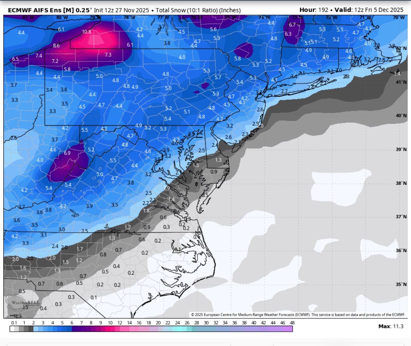
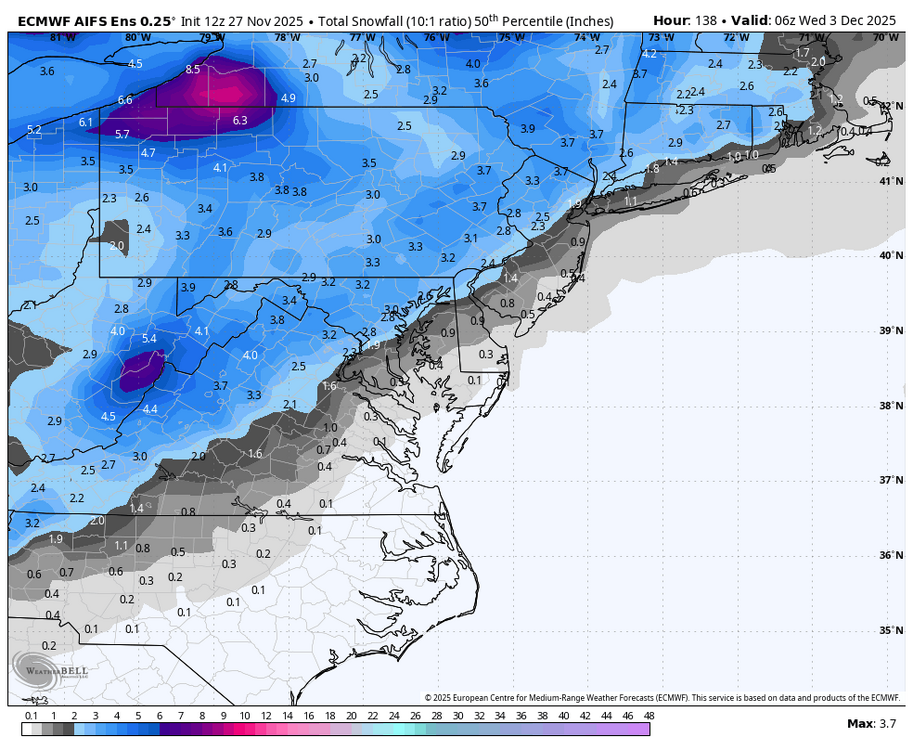
Got the median for the AIFS thru 138 - pretty impressive. Not caving to the parent. Still waiting for the mean.
-

December 2025 regional war/obs/disco thread
ma blizzard replied to Torch Tiger's topic in New England
based on 500 mb I would have thought it would be a bigger hit tbh can't complain though that was a near ideal run for SNE and plenty of opportunities after this one -
.thumb.png.4150b06c63a21f61052e47a612bf1818.png)
December 2025 regional war/obs/disco thread
HIPPYVALLEY replied to Torch Tiger's topic in New England
Saturday -
Not looking at modeling all summer I wouldn’t know how the AI has performed.
-
NO
-
(002).thumb.png.6e3d9d46bca5fe41aab7a74871dd8af8.png)
E PA/NJ/DE Autumn 2025 Obs/Discussion
ChescoWx replied to PhiEaglesfan712's topic in Philadelphia Region
Both the Euro and GFS have the Miller B type low developing pretty far south off the NC border - a bit unusual as in recent years we have seen lows forming more north and east. Euro a bit more strung out but would if to be believed give most folks N and W of 95 their 1st measurable snow before any mix or change to rain. -
Happy Thanksgiving! 24 and light snow on and off all day. Very festive as we cook.
-
It’s a bit of a red flag but I’ve seen the AI totally out to lunch before and it has been slowly but surely ticking NW the last few runs. Watch the vort track…that usually tells you. It’s currently tracking from like central PA into LI/RI. That’s not really a big suppressed look to me. It can become suppressed if the vort/energy gets ground up too much but it’s still pretty defined in PA.
-
What happened to him?