All Activity
- Past hour
-
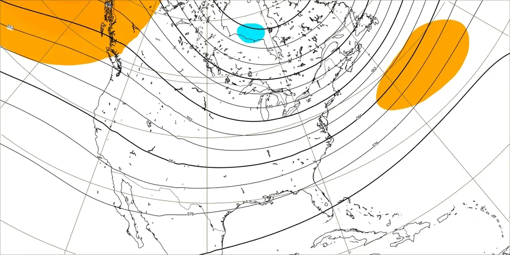
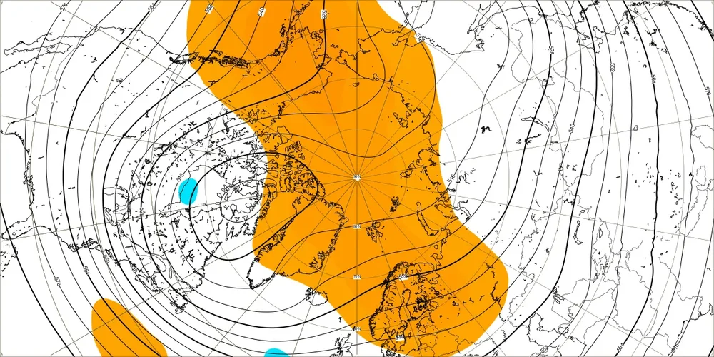
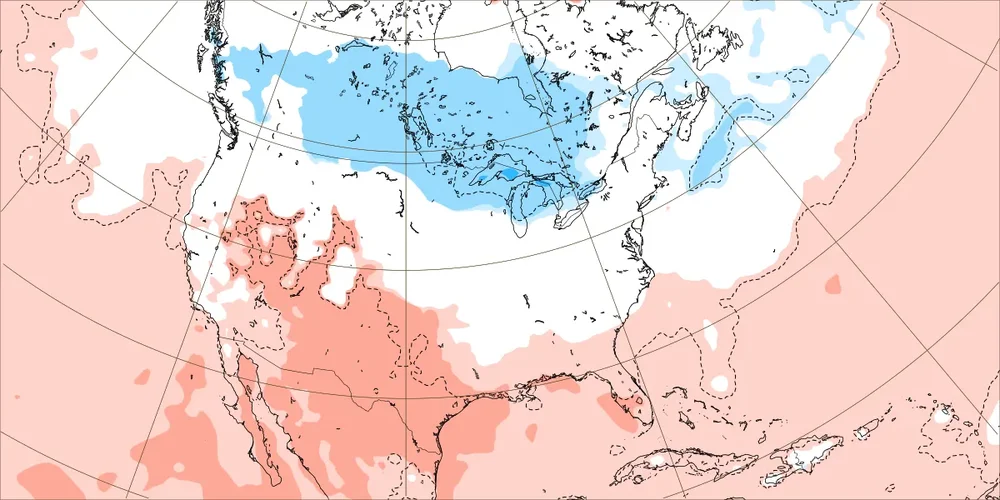
Today’s Euro Weeklies for 12/22-1/18 are even slightly uglier than yesterday’s ugly maps with a strong -PNA bringing warmer than normal for each week’s average for most of the US with the strongest warmth from the lower Midwest through the C/S Plains to the SW US, where it torches for part of the time. The E US is still clearly warmer than normal but like yesterday no torch dominates. Hopefully, these maps fail miserably but I hate seeing them. But in case they were to not fail and before y’all jump off of a cliff, there is some good news for the first run with the new week (1/19-25): it transitions toward a -EPO/+PNA/-AO/-NAO. Maybe, this is a sign of better things to come by mid to late Jan? For 1/19-25: N America H5 Global H5: N America 2m temps: ahhhh!
-

December 2025 regional war/obs/disco thread
TauntonBlizzard2013 replied to Torch Tiger's topic in New England
I know people always comment on who posts and what to expect, but the biggest indicators is who isn’t posting. Scooter hasn’t chimed in wt all. Tells you all you need to know about this “threat” -
I’d sign for this so fast.
-
December 2025 regional war/obs/disco thread
TauntonBlizzard2013 replied to Torch Tiger's topic in New England
NAM back to a graze. 2” on the beaches maybe and then a coating up by the pike -

December 2025 Short/Medium Range Forecast Thread
Carvers Gap replied to John1122's topic in Tennessee Valley
The 12z CFSv2 also lends some support to the "jail break" cold pattern potential just after Christmas. -

Minor snow possible sunday 12/14/25
WeatherGeek2025 replied to WeatherGeek2025's topic in New York City Metro
nam doesn't look good -

12/14: Sunday funday? Will the south win again?
Maestrobjwa replied to TSSN+'s topic in Mid Atlantic
Well that would be cathartic! Sounds like we have our goalposts...now we wait, lol -

Minor snow possible sunday 12/14/25
eduggs replied to WeatherGeek2025's topic in New York City Metro
Noticable shift ESE with the PV on the 18z NAM. Looks more suppressive. Bummer... was really hoping to get lucky with this one and keep trending it. Although it shouldn't be surprising that the outlier solutions shift towards model consensus. -
18z NAM is more south and has similar QPF as 12z. Drops 6" just NW of Baltimore.
-

12/14: Sunday funday? Will the south win again?
soadforecasterx replied to TSSN+'s topic in Mid Atlantic
We all just got Nam'd!!! -

12/14: Sunday funday? Will the south win again?
NorthArlington101 replied to TSSN+'s topic in Mid Atlantic
NAM much better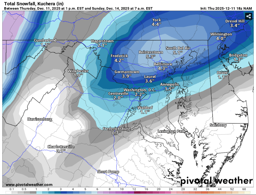
-

Winter 2025-26 Medium/Long Range Discussion
Radtechwxman replied to michsnowfreak's topic in Lakes/Ohio Valley
Hoping it doesn't follow baroclinic zone put down by today's snow and more so the incoming temp gradient with the arctic front. ILX seems to think it will follow snow swath of today's system and be more south. Models right now disagree. But obviously could change. -

12/14: Sunday funday? Will the south win again?
adelphi_sky replied to TSSN+'s topic in Mid Atlantic
I'm going to will it West 50 miles! -

12/12: The little Friday clipper that could? Or won't.
EstorilM replied to dailylurker's topic in Mid Atlantic
Whaaaat is the deal with central/SW Virginia this (and last I believe?!) season? Theres no way RIC has more annual snowfall than IAD lol. Then again as someone above said, they could be at their annual snowfall for the season in a few days. -
December 2025 Short/Medium Range Forecast Thread
Carvers Gap replied to John1122's topic in Tennessee Valley
Here is a prime example of the ensemble mean being skewed by anomalous members. I mentioned this yesterday. A substantial number of members from the EPS(2 sets of panels) and the GEFS (1 panel), have a cold front coming through on Christmas or the day after. The first group of thumbnails is from the GEFS at 366. Most of those members have a cold front pushing through. The EPS also has several members which produce cold. Surprisingly, the 12z GEFS has more of colder solutions. (I am pretty sure the GFS and GEFS were not updated at the same time. That leads to some discontinuity between the two at times.) This "could" be the first chink in the armor of the duration of the presumed, longer-duration warmup. Time will tell. In early December, the first signs that modeling was reverting...the oddball deterministic run which became more common and individual ensemble members. -
Don’t like their graphics though
-

December 2025 regional war/obs/disco thread
WinterWolf replied to Torch Tiger's topic in New England
As I said earlier, when we want the PV to get involved it doesn’t. When we’d like it to retract a tad, it doesn’t. Hilarious. Snow for everybody…no snow for SNE. Oh well. It’s extremely early, so I guess there’s that. -

December 2025 regional war/obs/disco thread
Typhoon Tip replied to Torch Tiger's topic in New England
'Good Heavens! are you guys still trying to win?' -
December 2025 regional war/obs/disco thread
TauntonBlizzard2013 replied to Torch Tiger's topic in New England
Yup, it’s pressing further SE this run, so I’d bet we get a scraper at best -

Minor snow possible sunday 12/14/25
CPcantmeasuresnow replied to WeatherGeek2025's topic in New York City Metro
Has there been a comparable period for this feature, for this long a period in our observable past? -
Not liking NAM trend at 18z, fwiw... 18z Saturday/0z Sunday is a key litmus I've been using on all guidance... all about pin-the-PV-center-on-the-lake... the further northwest that lobe center is, the better the downstream heights and tilt of our trough for our storm a day later: Over Lake Superior, high-end advisory. East of Lake Huron, it's a scraper.
-

12/12: The little Friday clipper that could? Or won't.
Herb@MAWS replied to dailylurker's topic in Mid Atlantic
I feel bad for folks who moved out to Frederick 20-25 years ago in order to get away from the I-95 craziness. Frederick has gotten so built up — and you don’t want to get caught up in their rush hour on Rt. 15. We hike near/at the Catoctins frequently and getting onto 70-east to head home is frequently a challenge. 34° here currently. -
December 2025 regional war/obs/disco thread
WinterWolf replied to Torch Tiger's topic in New England
Cold out there today. Brrr. -

December 2025 regional war/obs/disco thread
Chrisrotary12 replied to Torch Tiger's topic in New England
Not the most consistently windy day, but the gusts have been impressive. -
December 2025 Short/Medium Range Forecast Thread
Carvers Gap replied to John1122's topic in Tennessee Valley
Somewhere, Larry Cosgrove has to be smiling. The Euro Weeklies have a strong EPO by about Jan 17th. So, we need to weather the storm between Dec 20 and Jan 20. It seems like the patterns this winter are not as stable as past winters, i.e. they are shorter in duration(4 weeks and not 6 weeks). If we can swing a cold air mass or two during that "warm" time frame, that would be awesome. If we can find a way to go cold during that time frame, we have a shot at a cold winter. We are all pulling for the 12z Euro to be a trend and not a blip. It does actually have support from the 12z GFS which is just about 48 hours later w/ the trough pushing east. But huge grains of salt at that range.


