All Activity
- Past hour
-
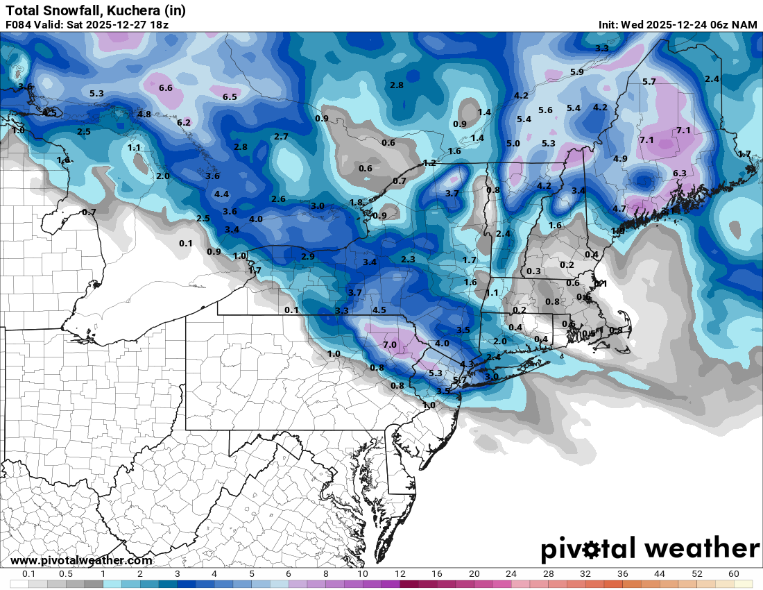
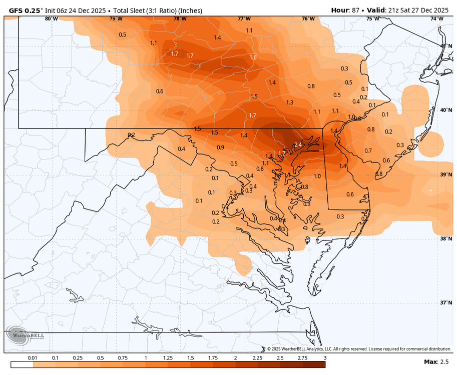
I think you'll find nearly every met in the SNE forums will tell you don't use it. There's a lot more to snow growth and high ratios then just temperatures. You can easily get 8-10:1 arctic sand with needles and plates with temps in the 10s and conversely you can get 15-30:1 fluff with sfc temps near freezing. Kuchera is always gonna be inflated really high like this when the column is very cold. You can use it if you want, im just saying there's a lot more to look at than pretty kuchera snowfall maps.
-

White Christmas Miracle? December 23-24th
moneypitmike replied to Baroclinic Zone's topic in New England
Last of my posts: HRRR keeps this going for another 2-3 hours. Early contender for the storm of the season for here. My P/C is calling for a new 3-5 for today. -
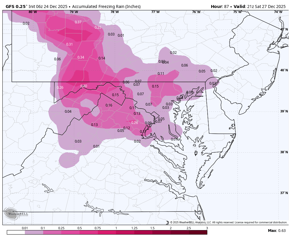
WB 6Z GFS
-
Everyone has their opinion on the kuchera. Mixed reactions because this will be a high ratio snow. I was told to use it with high ratios. I never did at all though.
-
White Christmas Miracle? December 23-24th
moneypitmike replied to Baroclinic Zone's topic in New England
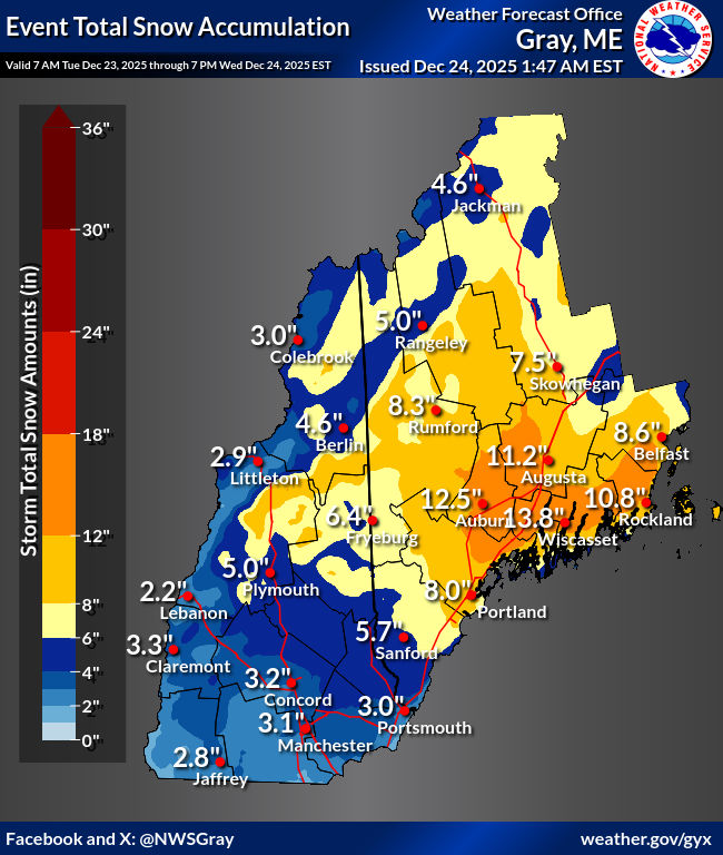
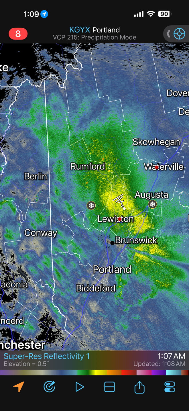
And so it is as GYX writes below. It is just dumping. My favorite part of this where it says "nearly stationary". 443 AM EST Wed Dec 24 2025 ...An area of heavy snow will affect Kennebec...west central Knox... northern York...Oxford...west central Waldo...Androscoggin...south central Somerset...Lincoln...Cumberland...Sagadahoc and southern Franklin Counties... At 437 AM EST...An area of heavy snow was impacting much of western and coastal Maine and nearly stationary. Locations impacted include... Belgrade, Scarborough, Jay, New Gloucester, Wales, Whitefield, Bath, Fayette, Livermore Falls, Rangeley, Mount Abram, Smithfield, Frye Island, Winslow, Lewiston, Boothbay, Bowdoin, Georgetown, Albany, and Standish. This includes the following highways... Interstate 295 between mile markers 1 and 51. Interstate 95 between mile markers 39 and 136. This also includes... Sebago Lake, Pleasant Mountain, Burnt Meadow Mountains, Saddleback Mountain, and Mount Abraham. Peaks Island, Long Island, Cushing Island, Cousins Island, and Bailey Island. * Visibilities will drop quickly to less than a half mile in this area of heavy snow. * Snowfall rates of 1 to 2 inches per hour are occurring in this area of heavy snow. -
White Christmas Miracle? December 23-24th
moneypitmike replied to Baroclinic Zone's topic in New England
At least as far as mby goes, this looks like it could be spot on -

Occasional Thoughts on Climate Change
frontranger8 replied to donsutherland1's topic in Climate Change
At the same time, Juneau hits -10, equalling coldest temp since the 1970s. And: https://www.cbc.ca/news/canada/north/yukon-energy-blackouts-extreme-cold-9.7026976 These things aren't one way. -
White Christmas Miracle? December 23-24th
moneypitmike replied to Baroclinic Zone's topic in New England
I'm 8 miles east of Brunswick in the middle of the GYX radar hole, ftw. By the way--I think until perhaps just now, that has been heavy, wet snow. Temp was hovering right around freezing through the duration until about an hour ago. Cooler air filtering in now.
-
Because it shows the most snow... The kuchera maps are ridiculous for the storm like nearly 1.5X or double 10:1 because its so frigid, esp N and W. When it's cold Kuchera will show a lot of snow. Doesn't take into account lift in the DGZ, frontogenesis or anything...strictly based on temps. I agree with the NWS and a lot of mets on here. I don't use it, it's useless imo.
-
White Christmas Miracle? December 23-24th
moneypitmike replied to Baroclinic Zone's topic in New England
Just got up. Eyeballing about 8" with SN++ at the moment. Double digits look doable, maybe even a foot based on what last night's models were showing for the morning hours. First, coffee. -
 0.66666:1 SWE. Epic. I'm working on a Tri-State Snowfall map now, should be done by mid-afternoon once i get cocorahs and coop. I went through the past 5 pages and got everybody on here. Thanks!
 -

26th-27th event, coming at us like a wounded duck.
DJln491 replied to Go Kart Mozart's topic in New England
Some NE creeping on the overnight runs. Wouldn’t take too much more to get a good hit for Hartford. - Today
-
-

Central PA Winter 25/26 Discussion and Obs
Ruin replied to MAG5035's topic in Upstate New York/Pennsylvania
I DONT WANT NO DAMN ICE STORM -

White Christmas Miracle? December 23-24th
dendrite replied to Baroclinic Zone's topic in New England
Beast trough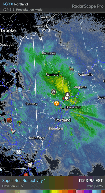
-
White Christmas Miracle? December 23-24th
dendrite replied to Baroclinic Zone's topic in New England
5.6” Still snowing decently -

Central PA Winter 25/26 Discussion and Obs
Festus replied to MAG5035's topic in Upstate New York/Pennsylvania
Watch hoisted for the whole forum. More than 48 hours in advance - might be a new record for CTP. Heavy mixed precipitation possible. Total snow and sleet accumulations up to two inches and ice accumulations between one tenth and three tenths of an inch possible. -

White Christmas Miracle? December 23-24th
WxWatcher007 replied to Baroclinic Zone's topic in New England
Hovering at 32° but the fluff is here. We’ll see what we can do overnight. -

-
Up to 8" now.
-

White Christmas Miracle? December 23-24th
TheSnowman replied to Baroclinic Zone's topic in New England
Showing beautifully here in Mt. Washington, but I’ve bright my curse with me. And STILL left the curse at home. Looks like we got 0.5” in RI IF that, and only 2” here. Even though it was 4-8 predicted. SOMEHOW everyone In Between here and RI overachieved and Massive is killing it. I’m a G-d Da*n Walking Snow Curse. And Couldn’t see the Mountain All 3 days (the Main train to come) because of the clouds, Even on Monday which was clear…. there was a cloud over Washington. AND THERE IS HARDLY any snow here even after hearing you all tell me “Northern New England is having a HISTORIC start to the season….” Well Where is it??!! Where is the 2 feet on there ground? Everyone here is saying “Oh Friday’s Rain wiped us out.” Even the Sleigh Rides are Down because the trails got screwed by the rain. And now the End of the week will be a storm TOO FAR SOUTH like 2 weeks ago where Delaware and Maryland and NYC Philly beat me? Oh My GOD!!!!!! W. T. F. -

Boxing Night Snow/Sleet/Ice Dec 26-27 Storm Thread/Obs.
RedSky replied to Mikeymac5306's topic in Philadelphia Region
0z guidance all backed north northeast -
Jaws at the end of the 0z Euro. This doesn't tell me much other than the fact that January will be fun to track even in the first half, and BAM will likely be right about a major winter storm happening around their timeframe of Jan 4-8.

-
Thanks Don, Just ripping in this band with great snow growth.

-

White Christmas Miracle? December 23-24th
40/70 Benchmark replied to Baroclinic Zone's topic in New England
2.75" should do it.