All Activity
- Past hour
-
Bro we are the same.
-

November 2025 general discussions and probable topic derailings ...
CoastalWx replied to Typhoon Tip's topic in New England
Get it to 50mb before we whack it to wind reversals over the moon. -
Agreed, the wind is certainly a factor as well as the timing of clouds moving in/out. There is no way to pin my stats on any one reason, they just are what they are.
-
For non-radiating locations right on the Hudson from northern Westchester to southern Dutchess, this fall has felt just about normal for the past 20 years. It's been consistently cool and not cold with a lot of wind. That should skew the radiating spots warm but less so the river towns.
-

Central PA Fall Discussions and Obs
pasnownut replied to ChescoWx's topic in Upstate New York/Pennsylvania
ditto. I've picked more off of me in my time afield this fall, than I have in quite some time. then theres that new tick that says "no more meat for you"...meat eater. That would really suck. -
Ever since the 1998 super El Nino, temp profiles changed up here. After the Pinatubo eruption effect wore off in the mid 90's, it was like a switch was flipped. Urban sites aside, even rural sites show this pattern change.
-
Lots of variables factor into this, like surface type, time of year, time of day but it can be more of a difference than people realize. To that point, my lowest temp of the season occurred this morning and its only 25. Most years I'd have some lows in the teens by now.
-

Pittsburgh PA Fall 2025 Thread
Rd9108 replied to TheClimateChanger's topic in Upstate New York/Pennsylvania
Eventually it breaks. You know these things go in cycles. -

November 2025 general discussions and probable topic derailings ...
WinterWolf replied to Typhoon Tip's topic in New England
Well, technically-not really . But we’ll all keep an eye on things. -
The 6th works for me. Have a wedding on the 13th of December. But the 20th I could probably do too. Thanks for putting this out there Ray.
-

November 2025 general discussions and probable topic derailings ...
MJO812 replied to Typhoon Tip's topic in New England
Game on
-
 I'm wondering if there is any way at all we can really know?
 -
Like last year Plenty of cold but the pacific didnt cooperate.
-
I got 8 inches in one event 2 winters ago. Some of these posts are absurd. Its like we live in Florida.
-

-
Some of these people are nuts. Many area's during the crap stretch have gotten a 4" snowfall or more within a 15 mile radius of NYC. NYC had bad luck during those storms, mostly because of the storm track being a tiny bit off for them. I went over it several times, but some are just too stubborn.
-
ALEET
-
November 2025 general discussions and probable topic derailings ...
WinterWolf replied to Typhoon Tip's topic in New England
I feel the take away is, things are heading in a decent direction it seems, and the chances are now just starting to show up. This is good. -
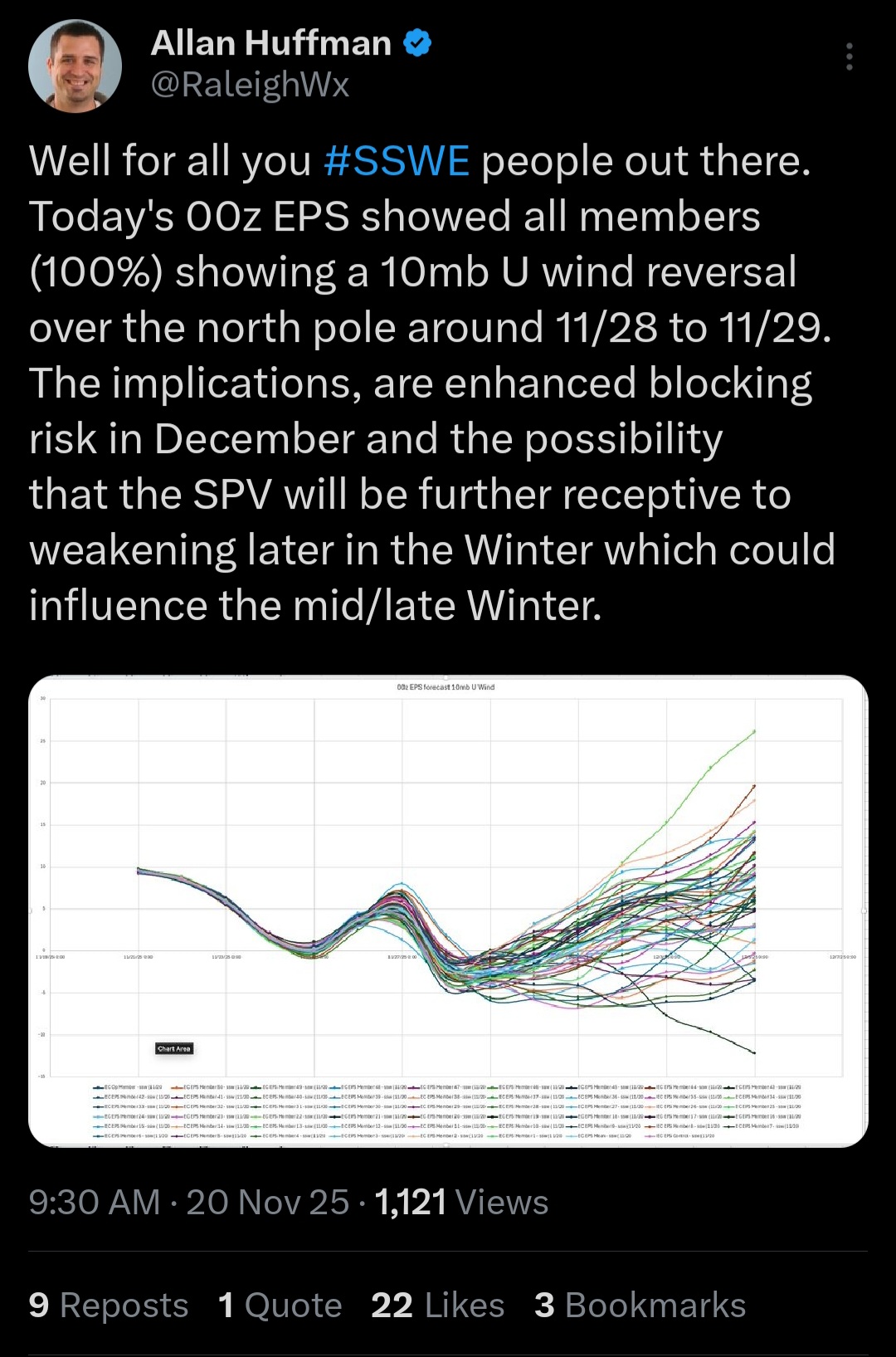
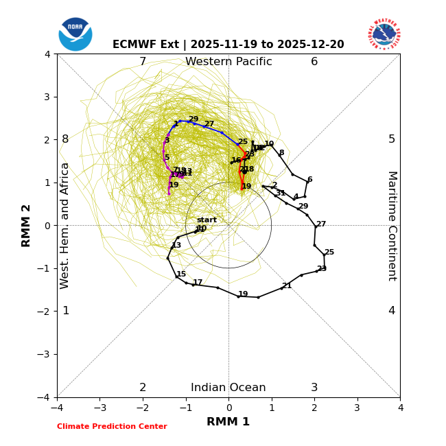
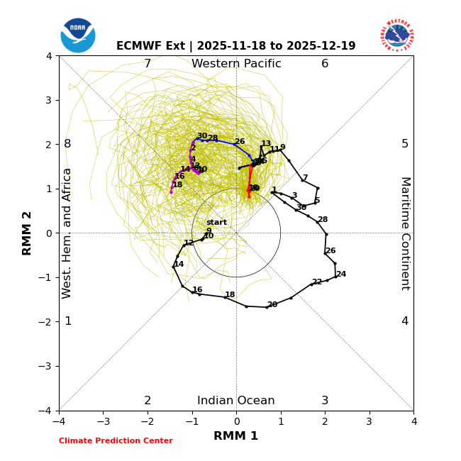
Today’s GEFS gets to phase 7 a day earlier than yesterday’s (11/28 vs 11/29) and three days earlier than the run from 2 days ago. The 11/19/25 Euro-ext gets it to phase 8 ten days earlier (12/5) than the prior run (12/15): Prior run (11/18/25):
-
Warming events don't happen in the Summer. You mean in June in the South Pole?
-

Central PA Fall Discussions and Obs
Jns2183 replied to ChescoWx's topic in Upstate New York/Pennsylvania
Those guys have caused me to spend a few weeks on antibiotics over the years. I now only hike wearing pants and long sleeves Sent from my SM-G970U1 using Tapatalk -
November 2025 general discussions and probable topic derailings ...
CoastalWx replied to Typhoon Tip's topic in New England
With it being early in the season, 2 to 4 inches would be epic. -
You don't need a 500mb -NAO to have 10mb warming. Actually history is full of examples where the two are at odds. It correlates +40dm -NAO at Day+0, but a +100dm -NAO at ~+30 days (+25-35 days), which is the end of December. Let's see if we get a 2nd -NAO period later in Dec.
-
Yeah, you would expect the fall low so far to eventually get down into that range. Not really cold by their standards over the short period of record since 1998. They got much colder in the fall of 2018 down to -21° on 11-23-18. Time Series Summary for SARANAC LAKE ADIRONDACK REGIONAL AP, NY - Sep through Nov Lowest Temperature Click column heading to sort ascending, click again to sort descending. 2025 2 11 2024 13 0 2023 4 0 2022 0 0 2021 -2 0 2020 3 0 2019 -9 0 2018 -21 0 2017 -3 0 2016 18 0 2015 9 0 2014 -3 2 2013 -13 0 2012 -4 0 2011 9 0 2010 2 0 2009 12 0 2008 1 0 2007 1 0 2006 11 1 2005 0 1 2004 3 0 2003 -1 1 2002 -9 0 2001 5 0 2000 -10 1 1999 -3 2 1998 6 Station Thread for Saranac Lake Area, NY Name Period in Thread 1 Saranac Lake Adirondack Regional Apt 06/01/1998 to 12/31/2024 2 Ray Brook 04/01/1978 to 05/31/1998 3 Gabriels 09/01/1966 to 03/31/1978 4 Paul Smiths 07/01/1949 to 08/31/1966 5 Gabriels 09/01/1908 to 09/30/1948 6 Paul Smiths 03/01/1903 to 08/31/1908
-
Did he? It was on models, now they have some pretty good +NAO troughing near Greenland with ridging underneath of it on the east coast. I think we are still below average temps though during the ridge because of -epo/+pna at the time.