All Activity
- Past hour
-
https://x.com/convchronicles/status/1959276496687903012?s=46&t=nTdsbQZkQMPkUI3zGjAXJg convective chronicles is planning on uploading a case study on the may 31st 1985 tornado outbreak i figured that yall would be interested looking back on it with the case study
-

Central PA Summer 2025
Mount Joy Snowman replied to Voyager's topic in Upstate New York/Pennsylvania
Just mowed, what a phenomenal day. Time for some libations and grilling. Next week is going to be heavenly. -
yes this looks pretty good. Still firing deep convection which is the most important thing. This def was a TD/TS a few days back which might speak to why it’s still holding together so well now
-
We march toward fall.
-
NNE cooking again. Deep summer day near 90°
-
I take it ultra warm winters like 11-12, 15-16, 19-20, 22-23, 23-24 were more or less unprecedented before this era no? It's not just that though. 21-22 and 24-25 were decently cold/seasonable, we just can't buy a big storm or frequent moderate storms anymore :/. Sucks and makes me want to move up north to VT or something.
-
This was posted on IND's fb page. Make of it what you will.

-
TS likely per NHC. Euro really struggled with its TC genesis signal here (and 99L surviving this long). Southwestern Atlantic (AL90): Satellite images and Air Force Reserve aircraft reconnaissance data indicate that an area of low pressure about 400 miles south- southeast of Bermuda continues to get better-defined, and recent satellite-derived winds indicate that the low pressure area has gale-force winds east of the center. This system is expected to become a tropical storm this afternoon or evening, with further intensification likely through Sunday while the low moves northward at 10 to 15 mph over the southwestern Atlantic. Interests in Bermuda should monitor the progress of this system, though the threat to that island appears to be less than yesterday. For additional information, including gale warnings, please see High Seas Forecasts issued by the National Weather Service. * Formation chance through 48 hours...high...near 100 percent. * Formation chance through 7 days...high...near 100 percent.
-
 This. I think we're cooked until the western pac stops boiling. Has there been a single extreme -pdo type winter that ended up good for us??
 -

2025-2026 ENSO
PhiEaglesfan712 replied to 40/70 Benchmark's topic in Weather Forecasting and Discussion
The only one I'd really take is 17-18. That's probably the closest thing to a great winter all-around since 13-14 and 14-15. I know we had the record warm February, but that was an outlier compared to the other months (December, January, March, and April), which were all below average. 15-16 and 16-17 were high variance winters, especially 15-16, which was dependent on one storm that skewed the entire season. Areas that missed the storm had record low snow totals. The greater frequency of warmer winters. You could start to see it as early as 2011-12. The great seasons of 2013-14 and 2014-15 interrupted the pattern. But after the mid-2010s el nino ended, you can definitely start to see a pattern change. -
1:51pm on an August 23rd. Thread bump time. Fourteen years ago at this moment was a fun time!
-
Whatever needs to happen to give us a mild/snowless winter is pretty much guaranteed to happen.
-
He was the editor-in-chief for the now defunct predatory journal Environment Pollution & Climate Change owned by OMICS. OMICS, subsidiaries, and personnel were investigated for academic fraud in 2016 and were found to have run as many 700 predatory journals and deceived numerous article authors. A judge ordered the India based company to pay $50 million in damages. Viterito defended his involvement with the predatory journal he ran. And his "scientific" positions defy credulity. He allowed an article that stated that the greenhouse effect cannot be real because the atmosphere does not have a roof like a real greenhouse. Even the most predatory of predatory journals would usually reject that kind nonsense. So this must have been a whole new level of ineptitude. If Viterito isn't a climate troll then he is doing everything he possibly can to convince everyone that he is. Why? I have no idea.
-
Any reasons you think the pattern has turned to levels of garbage for snowfall literally never seen before? After 2018-2019 it seems like something changed abruptly. Since then the only good winter month snow-wise for nyc was february 2021.
-
I think we have enough for a TD. If not now, at 5pm. Recon still sampling.
-
81/55 CoC everywhere!!
-
 I'm gonna do some painting upstate.
 - Today
-
Recon is in there now so we should know soon how close it is, or not.
-
Too early for me. 50s at night is great, but not even reaching 70 in the middle of the afternoon is a bit much. Plus lake effect clouds.
-
Still holding together as best it can in a very hostile environment
-

Occasional Thoughts on Climate Change
gallopinggertie replied to donsutherland1's topic in Climate Change
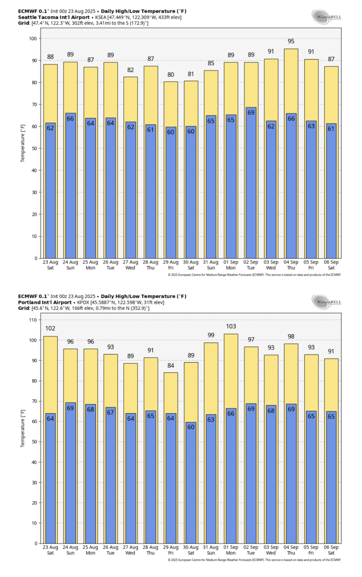
It’s looking like this might only be the beginning of this particular hot period - here’s the new ECMWF forecast for Seattle and Portland, showing a two-week stretch that would average 10-15 degrees above normal for the region. Pretty wild. I’ve lived in western Washington and Oregon my whole life, and the summer climate has really changed over just the past couple decades. Like you posted about, heat waves used to last maybe two or three days - now they stretch on for a week, or longer. Here in Portland our climate averages have historically fallen in the Csb (warm-summer Mediterranean) range, but are on track to push into Csa territory (hot-summer Mediterranean) before too long, perhaps when the new 2000-2030-year averages become the new baseline. Seattle probably will follow a few decades later.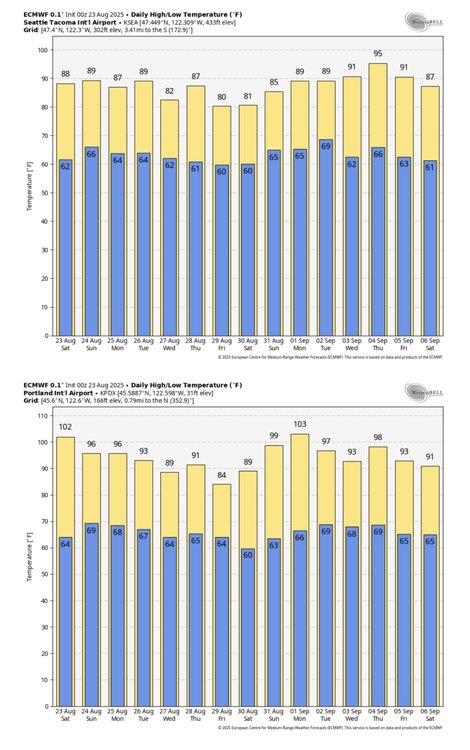
-
Currently 80/55 here in Tamaqua with a nice breeze blowing. This is about as perfect a summer day as you can get.
-
And I thought 0.28" was bad. Driest month since moving here is 0.31" in April of 1999. I think Monday will allow that mark to stand. 2nd is January 2004 at 0.57" and that may be in play. 3rd is 0.84" in both November 2012 and September 2014. I think they'll be tied for 4th on 9/1.
-
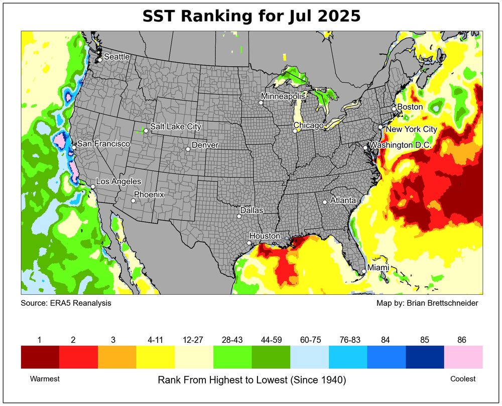
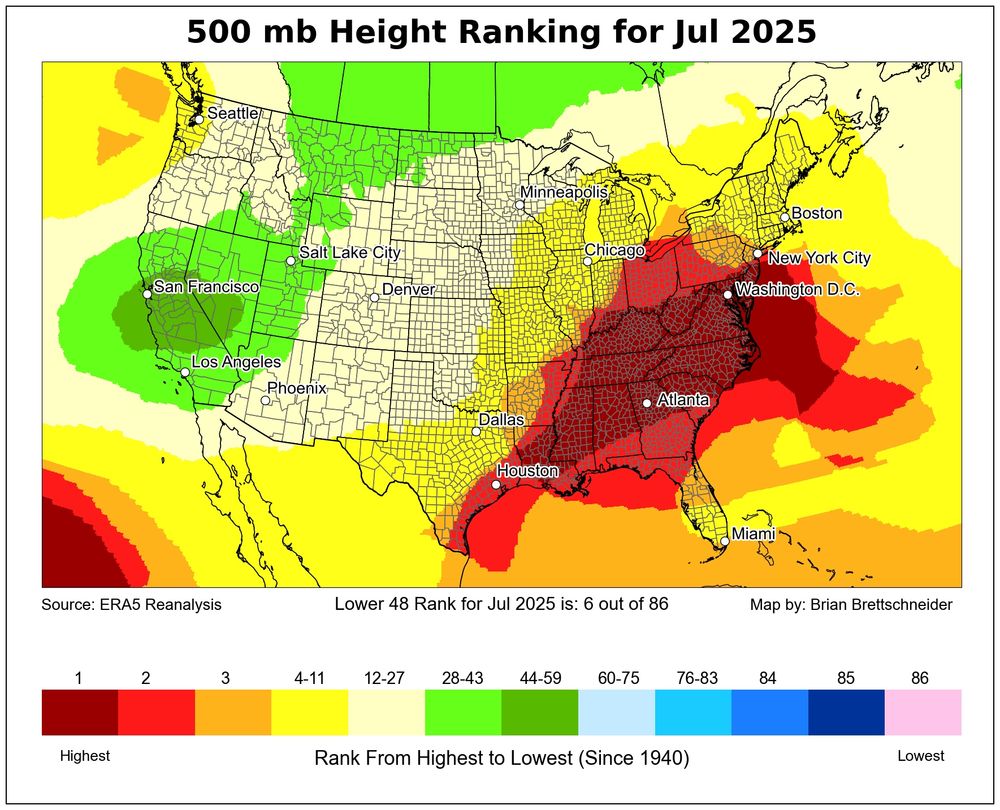
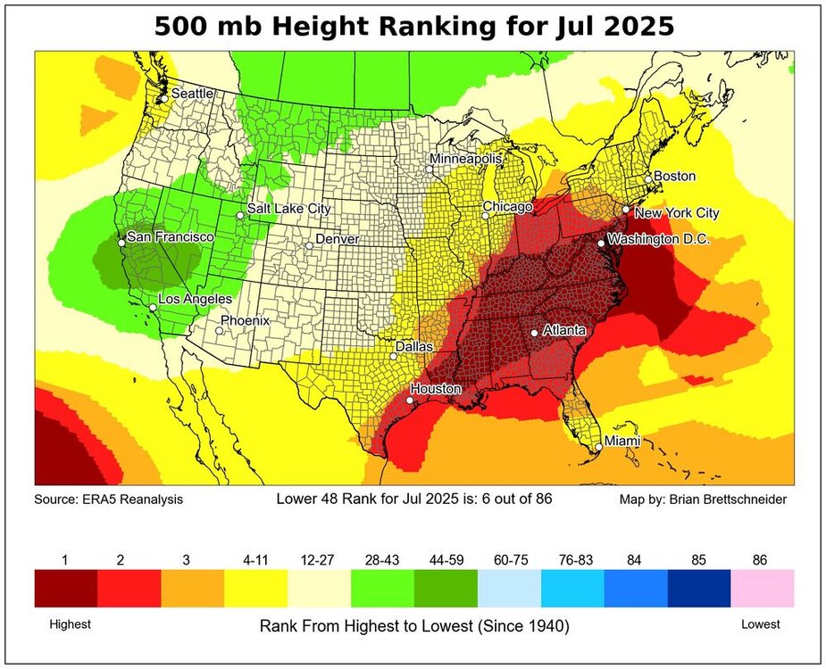
We had a record Southeast Ridge in July. So record Atlantic warm pool is in the mid-latitude band off the East Coast The record ridge back in the summer of 2023 was east of Canada leading to the record SSTs at higher latitudes.

-
What really gets me is all this hype information about La Nina winter coming. Like it's big headlines and it's going to be this strong La Nina. It seems to me that this La Nina pattern will be a very weak pattern and it won't even last all winter, but there's just so much out there on what they're saying. Honestly, the information is so misinformed on exactly what's going to happen that people just take what they read and go with it. Well in a week we'll be starting September and starting to get a better picture on where we're going. Starting to feel a bit of excitement.