All Activity
- Past hour
-

Mountain West Discussion
mayjawintastawm replied to mayjawintastawm's topic in Central/Western States
Looks like south and northwest were the winners this time. From COCORAHS
-

2025-2026 ENSO
michsnowfreak replied to 40/70 Benchmark's topic in Weather Forecasting and Discussion
Its extremely rare that I agree w/ TCC on anything, but I do on this one. Jan 1999 was an incredible stretch locally. PLUS...this came after multiple anemic winters. We didnt see a double digit snow depth from Feb 1994 thru Dec 1998, then bam, 2 feet on the ground in January 1999. Plus, the 1990s were my school years, so really 1999 was snow Id never seen before. Deeper snow was far more common in the 1970s-mid 1980s and 2000s-2010s than it was from the late 1980s to late 1990s, ie: my childhood. It remains the 3rd snowiest January on record (27.3"), behind only 1978 (29.6") & 2014 (39.1"). This is a pic of my mom shoveling snow Jan 13, 1999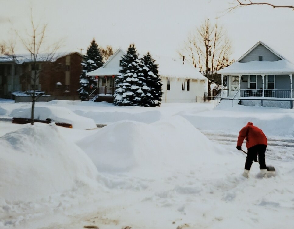
-
go cuddle up with it and take a nap.
-

2025 Atlantic Hurricane Season
BarryStantonGBP replied to BarryStantonGBP's topic in Tropical Headquarters
-
2025-2026 ENSO
michsnowfreak replied to 40/70 Benchmark's topic in Weather Forecasting and Discussion
I would take 2015-16 anyday over 1982-83 here. It was much snowier, tho still obviously a warm winter. -
2025-2026 ENSO
michsnowfreak replied to 40/70 Benchmark's topic in Weather Forecasting and Discussion
It was a blowtorch winter for sure. Especially Dec & Feb. Jan was seasonable temps but with record snow the first half here. The infamous blizzard of '99 on Jan 2nd was followed by storm after storm. Definitely made it memorable, but certainly doesnt hold a candle to great winters of the '00s-'10s. -

2025 Spring/Summer Mountain Thread
GoAPPS replied to Maggie Valley Steve's topic in Southeastern States
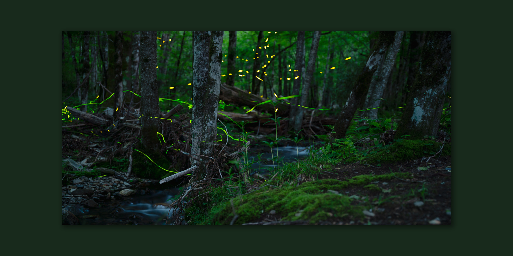
I've been heading out into the woods over the past couple of weeks to photograph the blue ghost and synchronous fireflies!
- Today
-
Looks like a rough morning for the Twin Cities. At least, it should move out fairly quickly.
-

2025-2026 ENSO
PhiEaglesfan712 replied to 40/70 Benchmark's topic in Weather Forecasting and Discussion
I'd argue the temperature jump in the 80s took place during the 86-88 el nino, rather than the 82-83 one. Global temperature for 1982 was lower than 1973 and 1978-81, and 1983's was right there with 1981. We really didn't break through the glass ceiling of 0.35 until 1988. -
Already 26C/79F - I'm thinking I get to 30 and over-perform. Low will be 21-22C overnight!
-
Yea, 45.1 here, too.
-
It won't beat May/June 2006 here. Back to back months of about 14" each.
-
Haha same, and my guy posts on this site. He helped me last year while my family was away on vacation and we got a 4" snow before Christmas.
-
Smoke plume thickest at this time in our area, but moving out in WV., so maybe some improvement later in the day, certainly once the winds shift to SW tomorrow. week. close up here https://www.star.nesdis.noaa.gov/GOES/sector_band.php?sat=G19§or=ne&band=GEOCOLOR&length=24
-
Third morning in a row that IAD gets down into the 40s. 47F for the low this AM.
-
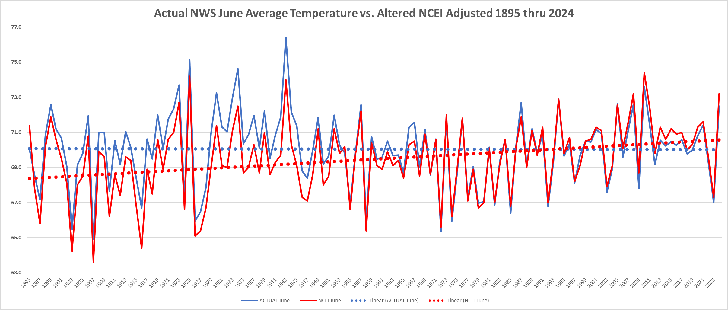
 Below is the June Actual National Weather Service Average June Average Raw Data Temperature vs. NOAA/NCEI Altered Temperature Data. Of note without the altered data June's here in Chester County have a slightly cooler trend line. After applying the adjustments we return to a warming trend. Funny how it always works that way.....
-
37.8 this morning. Glad to see there's a decent shot of another deluge this weekend. It's every boy's dream to get more rainfall than Kuala Lumpur. Let's make June another 10" plus month. What the hell...
-
Below is the June Actual National Weather Service Average June Average Raw Data Temperature vs. NOAA/NCEI Altered Temperature Data. Of note without the altered data June's here in Chester County have a slightly cooler trend line. After applying the adjustments we return to a warming trend.
-
E PA/NJ/DE Summer 2025 Obs/Discussion
ChescoWx replied to Hurricane Agnes's topic in Philadelphia Region
Below is the June Actual National Weather Service Average June Average Raw Data Temperature vs. NOAA/NCEI Altered Temperature Data. Of note without the altered data June's here in Chester County have a slightly cooler trend line. After applying the adjustments we return to a warming trend.
-
Pretty dense band of smoke over the eastern Lakes/upstate NY. We appear circumstantially protected for now but I’m wondering if that may get involved tomorrow …
-

2025-2026 ENSO
40/70 Benchmark replied to 40/70 Benchmark's topic in Weather Forecasting and Discussion
I was speaking of that winter in a NE US context, but it makes sense that it wasn't as bad in the GL region....that set up isn't as hostile there. -
So you're telling me there's not a cloud in the sky...but all of this overcast is wildfire smoke? Wow, lol
-

2025-2026 ENSO
TheClimateChanger replied to 40/70 Benchmark's topic in Weather Forecasting and Discussion
Nah, eastern Great Lakes. Still one of the snowiest Januarys on record in most areas, and like 90% of it fell in the first two weeks or so. I think we were out of school more than we were in school during that stretch. These don't even capture the fact that the big midwest blizzard brought a lot of freezing rain and sleet at the beginning of the month (1/2 to 1/3). So, yeah, that was a very impressive wintry stretch in an otherwise ho-hum winter. Erie - 4th snowiest January Buffalo - 3rd snowiest January Cleveland - 6th snowiest January Canton/Akron - 5th snowiest January Youngstown, Ohio - Snowiest on record -
That’s what I’m wondering … if/when the temp correlates. Maybe even how the particle physics works in that, but keeping it simple. … which circumstantially would also have dependency on accuracy for where the plumes will be located/density in time ….
-
I noticed those are the only ones that have the temperature jump.