All Activity
- Past hour
-

September 2025 OBS-Discussion centered NYC subforum
nycwinter replied to wdrag's topic in New York City Metro
summer is over nyc will not hit 90 again until next year! -
When I was a kid growing up, we were lucky if even the next few days forecast was correct. The computer models were really primitive during the 70s and 80s. But the Euro doing so well with March 93 and January 96 events began to give us some confidence in the 3-5 day forecast. Occasionally the model does really well on storm details day 6-10 like with Sandy. But the range beyond week 1 and week 2 is still very low skill. Maybe they can find a way for AI to bias correct the longer range NWP forecasts.
-

2025-2026 ENSO
40/70 Benchmark replied to 40/70 Benchmark's topic in Weather Forecasting and Discussion
Yea, I'm not arguing any of that...but temps and 500mb heights are kind of a big deal. I mean, I nailed snowfall last season...but I was too warm....that can't be ignored. -
Yeah, looking some better out there. NATL looking better as well.
-
Aaaaand the Steelers win. Jets played well overall and should have won.
-
Stopped raining hours ago . Stick to chopping wood
-
If we are looking for as close to perfection as we can get from an October seasonal forecast, then the JMA October 2013 record TNH forecast was pretty close. https://ds.data.jma.go.jp/wmc/products/model/map/7mE/map1/pztmap.php
-
LOL Brandon Stephens. Awkwardly dropped a would be interception that might have sealed it for the Jets. Then a typical PI call where he had zero awareness of where the ball was to help the Steelers on this drive that will probably win the game for them. Enjoy Jets fans!
-

E PA/NJ/DE Autumn 2025 Obs/Discussion
JTA66 replied to PhiEaglesfan712's topic in Philadelphia Region
Finished with .90”. Grass and mosquitoes are happy. -
.66 of rain last 24 hours, can't complain. Some areas over 2.50. Feast or famine.
-
-
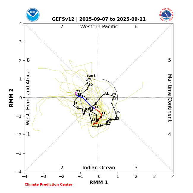
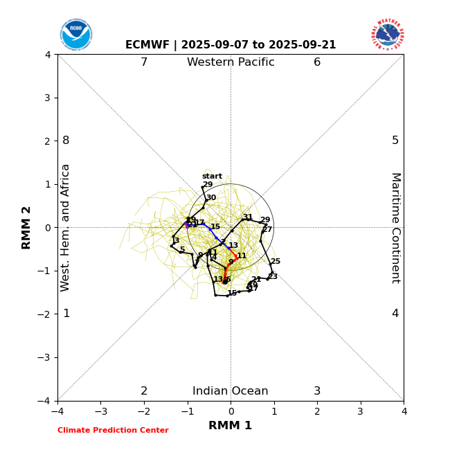
Snowman, the GFS and EPS MJO forecasts (the two best imho) for the next 2 weeks agree that the MJO will remain in the IO and then reverse back to the W Hem/Africa. I see no MC in site:
-

September 2025 OBS-Discussion centered NYC subforum
bluewave replied to wdrag's topic in New York City Metro
I know the NYC micronet in Fresh Kills made it to 92° yesterday and Newark was 90° along with Harrison.The next area of 90° highs was spread out from SNJ to CNJ. Fresh Kills 92 67 Climatological Data for HARRISON, NJ - September 2025 Click column heading to sort ascending, click again to sort descending. 2025-09-01 80 61 70.5 -2.9 0 6 0.00 0.0 0 2025-09-02 80 60 70.0 -3.1 0 5 0.00 0.0 0 2025-09-03 79 58 68.5 -4.4 0 4 0.00 0.0 0 2025-09-04 81 62 71.5 -1.1 0 7 0.00 0.0 0 2025-09-05 80 65 72.5 0.1 0 8 0.89 0.0 0 2025-09-06 86 67 76.5 4.4 0 12 0.00 0.0 0 2025-09-07 90 61 75.5 3.7 0 11 1.29 0.0 -
Low of 70, high of 89. Clouded over and hearing some distant thunder. Not much on radar right now but it is supposed to pick up soon. Getting very dry out there. We definitely need the rain.
-
MU talkin' drought today. Extended looking very dry.
-
Ray, I graded the Sept ‘24 Euro 2M temp. forecast for DJF 2024-5 an F, the worst Sept winter forecast going back at least to that of Sept of 2017, the furthest back I can find. The Euro US averaged ~4F too warm for most of the US! The only area it did well with was the SW. The Sept ‘20 Euro forecast for 20-21 was similarly too warm but not by quite as much (avg of ~3F too warm for the US). OTOH, the Sept forecast for 2023-4 was pretty bad in the other direction with an average miss of ~3F too cold for the US overall. The last good Sept Euro 2M forecasts for the lower 48 as a whole were for 2021-2 and 2019-20. The avg miss in the NE was very small.
-
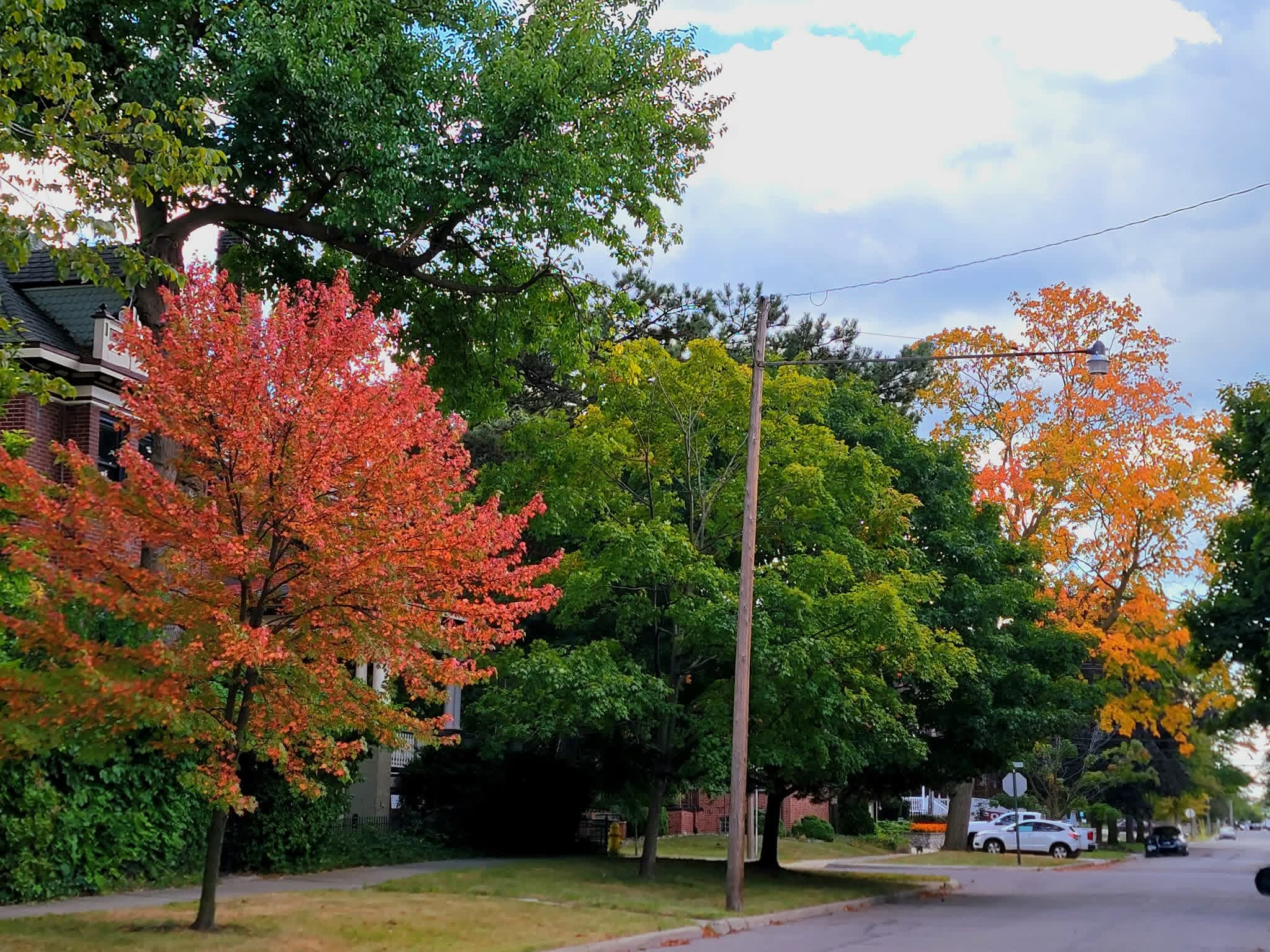
Color continues to expand. Seems like we will be looking at an early color show, especially if it stays dry.

-

September 2025 OBS-Discussion centered NYC subforum
Sundog replied to wdrag's topic in New York City Metro
What percentage of total stations in Upton made it to 90? Or at least within 50 miles of NYC? I ask because I don't know where most of those stations are and if they are in a tight geographic area it might not represent that much of the region. I also don't count stations that are too far away, for example I don't care if Philly gets to 90, they're 100 miles away. -
There are really three key elements of a seasonal forecast. General seasonal temperatures, storm tracks which includes P-types and amounts, and the 500 mb patterns. The Euro missed on the temperatures and 500mb heights. But the storm tracks and snowfall amounts were mostly right. So it just could be that the model stock La Niña forecast only worked out for the storm track through the Eastern Great Lakes. Unfortunately, this has been the default primary storm track since 18-19.
-
3:25PM: I’m getting a thunderstorm now, the first rain here this month.
-
Mostly dry but also normal to below normal temps through mid month. Longwave pattern supports surface HP to our NW/N/NE throughout.
- Today
-
2025-2026 ENSO
40/70 Benchmark replied to 40/70 Benchmark's topic in Weather Forecasting and Discussion
Well, that is where we differ. I know in the past I have ostensibly nailed seasons, but always detract from the grade when I'm "right for the wrong reason". Agree to disagree. The forecast was wrong....it just so happen to be correct regarding low snowfall. -
Barry, I don’t know why JB is saying that. The Sept 2025 MJO (first 7 days plus 2 week forecast through 9/21) looks nothing like 2024! Sept 2025: -GEFS: lower to moderate amplitude 2, 3, 2, 1, 8, which is actually favorable -EPS: lower to moderate amplitude 2, 3, 2, 1, 8, which is actually favorable Sept 1-21 of 2024 (blue): moderate to high amplitude 4, 5, 6 (not usually favorable unlike what we now have) was like night and day vs 2025: Perhaps JB is looking further ahead to late Sept-Oct. Regardless, he wants lots of clicks!


-
September 2025 OBS-Discussion centered NYC subforum
bluewave replied to wdrag's topic in New York City Metro
Yeah, the one constant is that the warm departures have consistently been more impressive than the cool departures over the years. So when we get these brief cooler patterns, the rebound back to warmer is of a greater magnitude. Whether we just bounce back to mid 80s later in September or see a few warm spots reach 90° again is still unknown.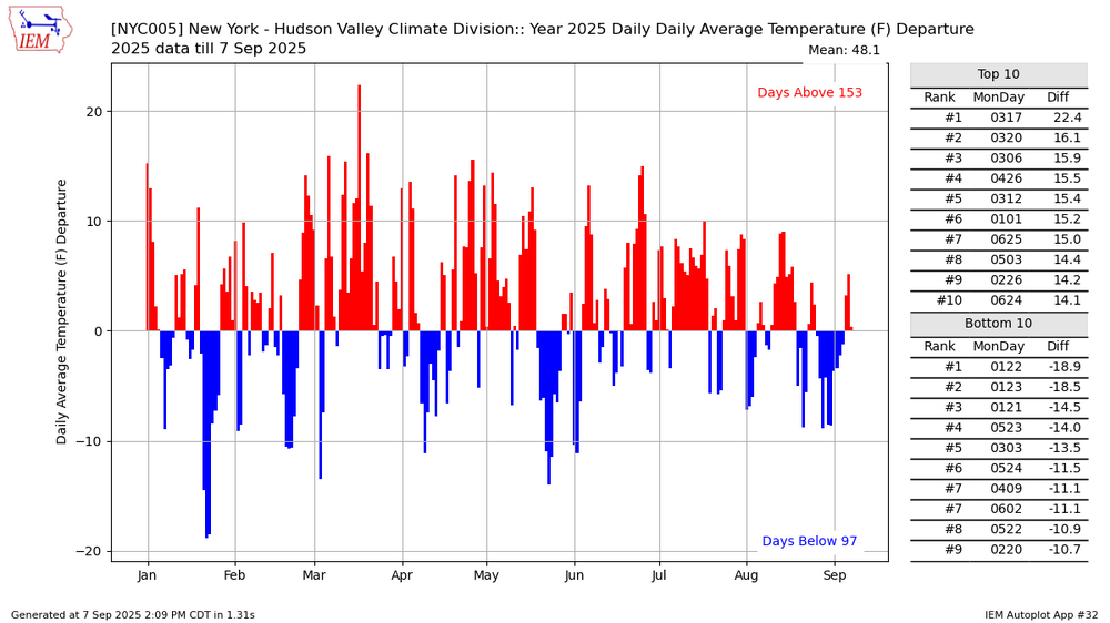
-
9/7/2015 (see below) was the last 9/7 TWO with no new TCG being considered. However, that was going into a strong El Niño, there was TS Grace then in existence in the E MDR, and the outlooks then went out only 5 rather than 7 days. Also, this TWO failed to see a new TD (which lead to Henri) that formed 9/8-9 in the subtropics: TROPICAL WEATHER OUTLOOK NWS NATIONAL HURRICANE CENTER MIAMI FL 800 AM EDT MON SEP 7 2015 For the North Atlantic...Caribbean Sea and the Gulf of Mexico: The National Hurricane Center is issuing advisories on Tropical Storm Grace, located several hundred miles west-southwest of the Cape Verde Islands. Tropical cyclone formation is not expected during the next 5 days. $$ Forecaster Pasch https://www.nhc.noaa.gov/archive/xgtwo_5day/gtwo_archive.php?current_issuance=201509071437&basin=atlc&fdays=2