All Activity
- Past hour
-
Im not sure if we gonna see a big warmup. So much cold air up north. Looks like a gradient pattern to me
-
Im not sure if we gonna see a big warmup. So much cold air up north. Looks like a gradient pattern to me
-
bengals tickets for a game w/ low teens air temp and sd's wind chill are going for about $20 on the upper bowl, lower for 40-50. Will probably be there, thats almost too good to pass up.
-
Im not sure if we gonna see a big warmup. So much cold air up north. Looks like a gradient pattern to me .
-

Minor snow possible sunday 12/14/25
WE GOT HIM replied to WeatherGeek2025's topic in New York City Metro
This is really a thread the needle setup -

December 14th - Snow showers or Plowable snow?
moneypitmike replied to Sey-Mour Snow's topic in New England
Glad we have a thread. -
GFS slight tick north
-

2025-2026 Fall/Winter Mountain Thread
Tyler Penland replied to Buckethead's topic in Southeastern States
Another dusting overnight. The NAM means business with the cold moving in Sunday. Drops Boone to 4° by 7PM. Could we go negative with snow cover? Sent from my Pixel 10 Pro using Tapatalk -

Minor snow possible sunday 12/14/25
Yanksfan replied to WeatherGeek2025's topic in New York City Metro
Another 25 mile bump north and most of us will be happy on this forum. -

Minor snow possible sunday 12/14/25
NittanyWx replied to WeatherGeek2025's topic in New York City Metro
I like the slightly more amped trends we're seeing today as well. -
if we can take a 10 year anniversary of the 2016 storm come January, that would be amazing.
-
Curious what your season snow total is now up there? With the last of the clipper train coming through today I was looking at various places in eastern/central MN over toward Green Bay, and while we’re not breaking records based on MN historically, certainly these two weeks have been a pretty impressive early winter period and better than I can remember for quite a while. Varies a little by exact location but: - 12-15 out of 17 days with snow recorded - Snow totals 15-20+” with most seeing two pretty solid 4-6” events - Broad swath of snow depth 8-12” - After this weekend, 7-10 days of min temp at or below 0 from Dec 1st through 14th (outside of MSP proper which stayed above zero a few more times) .
-

12/14: Sunday funday? Will the south win again?
caviman2201 replied to TSSN+'s topic in Mid Atlantic
I need the JMA in my life... someone used to post that one all the time when we got desperate -

Mid to long range discussion- 2025
WinstonSalemArlington replied to wncsnow's topic in Southeastern States
Sunday -
Driving to work. A few water main braues caused icy conditions but so did the apparent snow in Hudson county. 95 in Kearny, 3cits and at job were all coated in snow.
-

Minor snow possible sunday 12/14/25
forkyfork replied to WeatherGeek2025's topic in New York City Metro
this looks like a good setup for a northern fringe band -
Minor snow possible sunday 12/14/25
NittanyWx replied to WeatherGeek2025's topic in New York City Metro
I again point to the deep DGZ with this and think fluff factor will help. -

December 14th - Snow showers or Plowable snow?
CoastalWx replied to Sey-Mour Snow's topic in New England
Except the last one -
.thumb.jpeg.406ecda2eec9e267302c22b9f128fe3c.jpeg)
December 2025 regional war/obs/disco thread
kazimirkai replied to Torch Tiger's topic in New England
The extended GEFS seems to be picking up on this secondary SSW signal with the some winter in early January (mainly around the 4th-12th in today's run). I think there could def be some chances for snow in interior NE and especially mountains before that though (evidenced by snowfall on the 384hr ensemble suite). The central ridge seems to relax more westward following Christmas.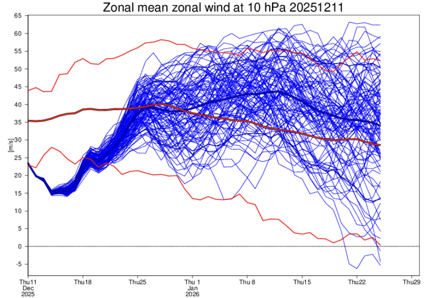
-
Good point. When I spent a few years in Vietnam, I was surprised how ham they went with the xmas decorations everywhere. It was weird to be admiring a huge xmas tree while wiping sweat off my brows. Anyhow back to the xmas torch - for some reason it happens around the holidays, with no apparent scientific reason behind it. But like I said, if we must torch, I’ll take it about now through the end of december. The last few times we actually had a very cold xmas, the following January (and sometimes Feb) torched. Take the torch now, and we’ll have our chances in prime climo starting around second week of Jan.
-

December 14th - Snow showers or Plowable snow?
MJO812 replied to Sey-Mour Snow's topic in New England
Yep. Happens every storm. -
Wonder if we’ll get one of those last minute north west bumps. Whenever we’re on the rain snow line it seemingly loves to happen and happily screw us.
-
Minor snow possible sunday 12/14/25
MJO812 replied to WeatherGeek2025's topic in New York City Metro
Gefs also improved. General 1-3/2-4 inches expected right now for the coast. -
Sad but true, i think i may still be left with 1". The way this winter is going i am happy with that.
-
Minor snow possible sunday 12/14/25
MJO812 replied to WeatherGeek2025's topic in New York City Metro
Cmc is 3-5 for NYC and SNJ
.thumb.jpg.ad3a2e31d30aff035044689b311a0540.jpg)


