All Activity
- Past hour
-

2025-2026 ENSO
TheClimateChanger replied to 40/70 Benchmark's topic in Weather Forecasting and Discussion
Nah, eastern Great Lakes. Still one of the snowiest Januarys on record in most areas, and like 90% of it fell in the first two weeks or so. I think we were out of school more than we were in school during that stretch. These don't even capture the fact that the big midwest blizzard brought a lot of freezing rain and sleet at the beginning of the month (1/2 to 1/3). Erie - 4th snowiest January Buffalo - 3rd snowiest January Cleveland - 6th snowiest January -
That’s what I’m wondering … if/when the temp correlates. Maybe even how the particle physics works in that, but keeping it simple. … which circumstantially would also have decency on accuracy for where the plumes will be located/density in time ….
-
I noticed those are the only ones that have the temperature jump.
-

2025-2026 ENSO
PhiEaglesfan712 replied to 40/70 Benchmark's topic in Weather Forecasting and Discussion
Yes, that's the list, though you could add 1972-73. -

2025-2026 ENSO
40/70 Benchmark replied to 40/70 Benchmark's topic in Weather Forecasting and Discussion
Yes, the winter overall sucked. You are in the mid atl, I assume? -
cloudy or sunny that day-- the lows were similar to 6-4-23 but the highs were lower
-
2015-16 even worse than 1982-83, same one big storm winter
-
2025-2026 ENSO
TheClimateChanger replied to 40/70 Benchmark's topic in Weather Forecasting and Discussion
The first half of January was rocking in my neck of the woods. Maybe overall it was warm, but we had storm after storm to start the year. Probably the best two week stretch other than February 2010. -
All I know is the HRRR models it and I believe is tuned to show how it affects temps.
-
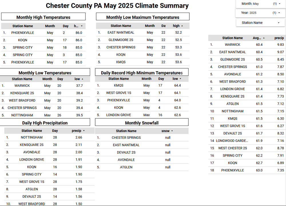
Below is the May Climate Summary for Chester County PA. We finished with a below average temperature of 61.5 our 30 year average May temperature is 61.9 degrees. This was the 61st chilliest May with 132 years of records. It was a very wet month with an average rainfall across the county of 7.70" this is the 4th highest average county rainfall since records began in 1894. The climate summary is detailed below with the warmest temperature at Phoenixville on May 2nd and the coldest at Warwick Township on May 20th.
-

E PA/NJ/DE Summer 2025 Obs/Discussion
ChescoWx replied to Hurricane Agnes's topic in Philadelphia Region
Below is the May Climate Summary for Chester County PA. We finished with a below average temperature of 61.5 our 30 year average May temperature is 61.9 degrees. This was the 61st chilliest May with 132 years of records. It was a very wet month with an average rainfall across the county of 7.70" this is the 4th highest average county rainfall since records began in 1894. The climate summary is detailed below with the warmest temperature at Phoenixville on May 2nd and the coldest at Warwick Township on May 20th.
-
6/3/1997 LGA 61 / 49 JFK: 62 / 50 NYC: 61 / 49 EWR:
-
what about super (+2) el ninos? I think only 1982-83, 1997-98, 2015-16 ?
-
38 and 39°F respectively here the last two days.
-
usually takes til mid June to get out of that season
-
Wet in the central plains, and southeast with the cut off low near Northern FL, GA, and the Carolinas this week, storms from the slow front get our area closer to the >1 inch Fri-Sat.
-

E PA/NJ/DE Summer 2025 Obs/Discussion
JTA66 replied to Hurricane Agnes's topic in Philadelphia Region
Current high temp forecast for mid week is only 85F now. We'll see. I imagine the increased soil moisture helps out somewhat. -
Cold front passed through the twin cities last night. Subsidence behind the front is bringing the smoke to ground level. The upper flow pattern had been out of the NW to my understanding. It’s a pretty thin band of surface level smoke. Western and Central Minnesota are already seeing improvements.
-
2025-2026 ENSO
PhiEaglesfan712 replied to 40/70 Benchmark's topic in Weather Forecasting and Discussion
Not really. Here are the high end el ninos (+1.5) since 1949-50 (bold are the very strong ones +2): 1957-58 (temperature jump: no) 1965-66 (temperature jump: no) 1972-73 (temperature jump: maybe) 1982-83 (temperature jump: yes) 1986-88 (temperature jump: yes) 1991-92 (temperature jump: no, but due to Mt. Pinatubo) 1997-98 (temperature jump: yes) 2009-10 (temperature jump: no, but 2010 was the warmest year on record at that point) 2015-16 (temperature jump: yes) 2023-24 (temperature jump: yes) The gap between strong el ninos seem uniform (although there was a higher frequency in the 80s and 90s, due to the +PDO period), and the gap between super el ninos is actually increasing (10 between 72-73 and 82-83, 15 between 82-83 and 97-98, and 18 between 97-98 and 15-16. We are currently at 9 and counting since 15-16.) -
does anyone have any insight/knowledge into specifically modeling accuracy for smoke ?
-
Ugh. As we all know once droopy cutoff low season starts it can be impossible to get rid of.
-
2025-2026 ENSO
40/70 Benchmark replied to 40/70 Benchmark's topic in Weather Forecasting and Discussion
Yes, but it was more widespread in that system because it was occluded, so there was just narrow area near the coast that got creamed under the low level deformation. -
Was just walking my pup in my yard and I see this huge black bear wander 100 feet away, eating bread my wife threw out for the birds. It went over the wall and is taking a snooze, waiting for him to get up so I can take a pic.
-
It's awfully nice out right now. I'm being totally lazy and just puttering around the garden rather than working. Looks like we're getting really lucky with the smoke so that's nice
-

2025-2026 ENSO
michsnowfreak replied to 40/70 Benchmark's topic in Weather Forecasting and Discussion
Thats awesome. Ive ran across some others who keep personal records. So cool to have us snow weenies that do that. If I am out of town and its going to snow, I have a standby observer for me too lol.


