All Activity
- Past hour
-

E PA/NJ/DE Winter 2025-26 Obs/Discussion
Kevin Reilly replied to LVblizzard's topic in Philadelphia Region
Overriding warm air I’d suspect meeting up with the northern stream vort to the north and storm gliding by south. -

January 2026 regional war/obs/disco thread
Sey-Mour Snow replied to Baroclinic Zone's topic in New England
Ya I mean 90% we all lose the pack this week pike south. I’ve accepted this for about 5 days now -
all of college sports is ridiculous now. You see 4500 players entered the transfer portal today? It's not sustainable.
-
Yeah, but that little 998 acts like a kicker to keep things moving and us on the right side of the gradient. But yeah, your map is nicer.
-
January 2026 regional war/obs/disco thread
Sey-Mour Snow replied to Baroclinic Zone's topic in New England
All ensembles look very good day 10-15. We are all just a bit jaded bc “when have we said that before” .. It’s time to really cash in with a good look. South of pike has to go through an ugly 4-6 days. Hopefully Pike north can cash in or at least hold the pack. -
This setup would end up mostly rain for the majority of our region.
-
33.6 for the high today
-

E PA/NJ/DE Winter 2025-26 Obs/Discussion
Ralph Wiggum replied to LVblizzard's topic in Philadelphia Region
Euro has snow showers around overnight and again Monday AM. -
january 15th KU potential? a day or two before or after! Get ready!
-
Snowed in on the Tug Hill. Boy... do i have a story for when I get home. I've witnessed nearly 8' of snow since Wednesday.
-

January 2026 regional war/obs/disco thread
dendrite replied to Baroclinic Zone's topic in New England
Wait...I thought you said this morning that you didn't like that look -
Well, not exactly. What I want is a shortwave riding the thermal boundary with cold HP to the NW pressing southward, not a goddamn 998 LP over the Great lakes lol. This-
-

January 2026 regional war/obs/disco thread
CoastalWx replied to Baroclinic Zone's topic in New England
Anyways end of EPS looks nice imo. Lingering cold with a flexing Deep South/SE ridge. I’ll take my chances. -
(002).thumb.png.6e3d9d46bca5fe41aab7a74871dd8af8.png)
Central PA Winter 25/26 Discussion and Obs
ChescoWx replied to MAG5035's topic in Upstate New York/Pennsylvania
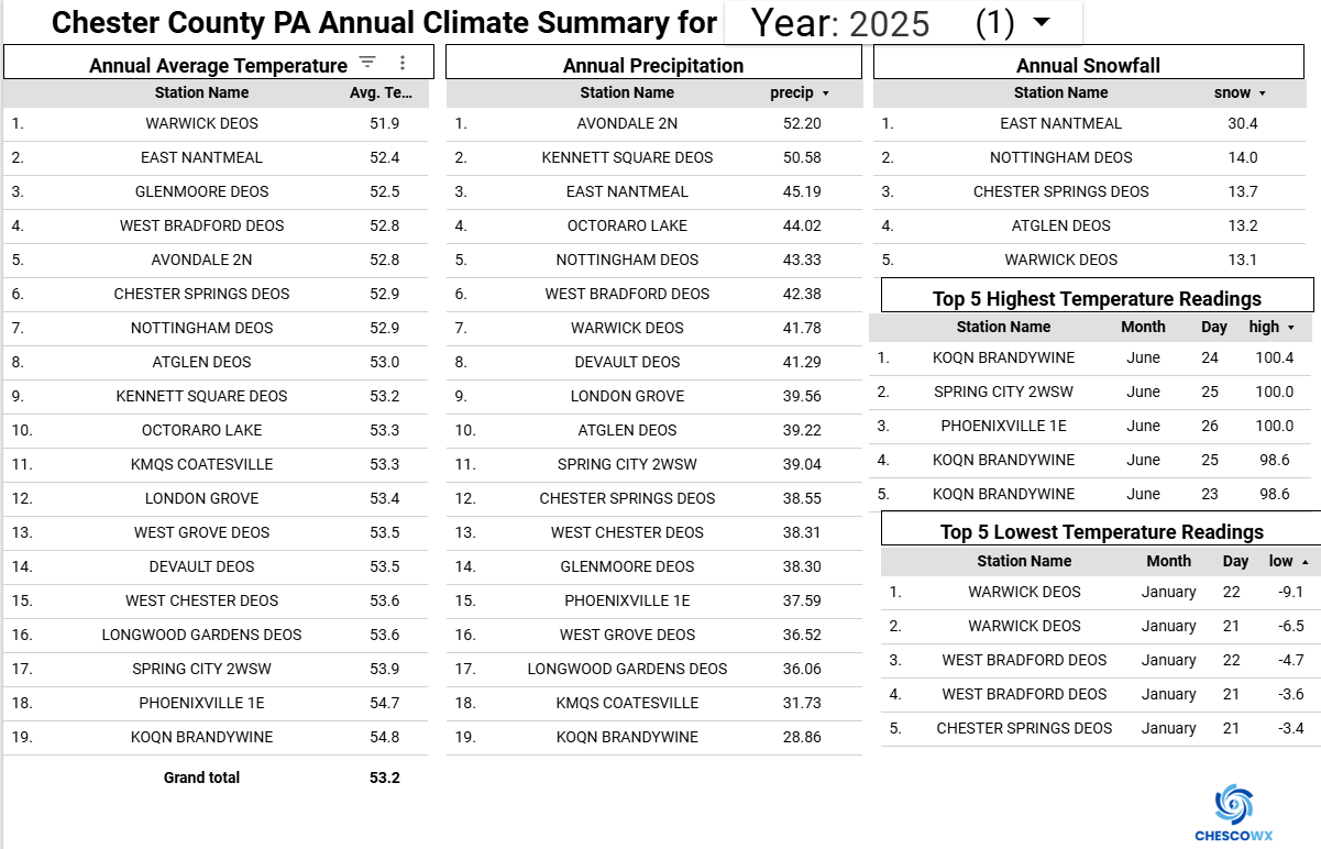
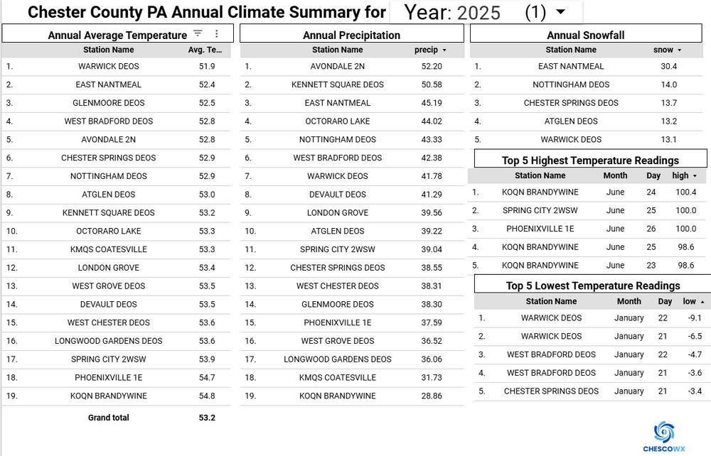
Below is the 2025 Climate Summary for Chester County PA
-
January 2026 regional war/obs/disco thread
dendrite replied to Baroclinic Zone's topic in New England
Not my first rodeo. "leaning below" I know I've ranted on these maps before, but I just always find them funny. I know what they're trying to imply, but they separate the probs into 3 categories (BN, N, AN) and slap a probability on each one and shade with whichever one is the highest. So they shade us in 40-50% probability of BN which translates to 50-60% (higher) chance of not BN. -
January 2026 regional war/obs/disco thread
CoastalWx replied to Baroclinic Zone's topic in New England
I thought I was the one having painkillers. Open bar happy hour in CT it seems. -
E PA/NJ/DE Winter 2025-26 Obs/Discussion
ChescoWx replied to LVblizzard's topic in Philadelphia Region
Below is the 2025 Chester County PA Climate Summary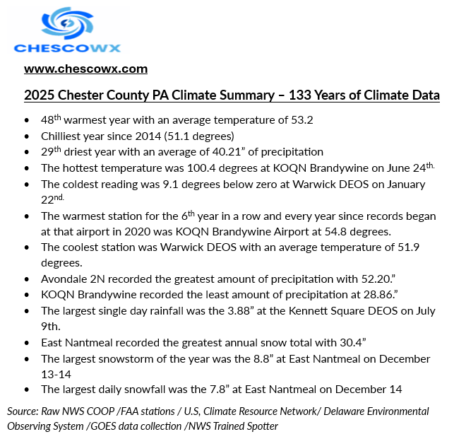

-
January 2026 regional war/obs/disco thread
CoastalWx replied to Baroclinic Zone's topic in New England
What is wrong with CT? -

E PA/NJ/DE Winter 2025-26 Obs/Discussion
penndotguy replied to LVblizzard's topic in Philadelphia Region
Im good with it as long as no one starts a Storm thread outside of 5 days that's grounds for therapy. -
Count me as not skeptical at all. Winter has had a great start. We will get our snow when cold fronts stall just to our south and east and waves of low pressure move up along them. We are already ahead of the pace of most recent winter seasons on snowfall and look to continue the pace by mid January. As I previously noted, there's a strong cold front which was timed for January 12th and is now timed for Jan 10th or 11th. Patience. WX/PT
-

January 2026 regional war/obs/disco thread
weathafella replied to Baroclinic Zone's topic in New England
They obviously think cold east outside of the Deep South and warm west. -
January 2026 regional war/obs/disco thread
dendrite replied to Baroclinic Zone's topic in New England
Has anyone EVER seen them issue those maps with any of the grey shading for an increased probability of "near normal"? I can't recall ever seeing it. Instead we get that boring 33/33/33% of equal chances. -
January 2026 regional war/obs/disco thread
dendrite replied to Baroclinic Zone's topic in New England
50-60% chance of near normal to above. Sweet. -

January 2026 regional war/obs/disco thread
Go Kart Mozart replied to Baroclinic Zone's topic in New England
He is dead nuts right. Can I suggest sunscreen and a big floppy hat? -

January 2026 regional war/obs/disco thread
WxWatcher007 replied to Baroclinic Zone's topic in New England
Subforum on edge