All Activity
- Past hour
-

2025-2026 ENSO
40/70 Benchmark replied to 40/70 Benchmark's topic in Weather Forecasting and Discussion
Yea, the wave length differences have made fall more invulnerable to some of these perturbations that are speculatively linked to CC. -
2025-2026 ENSO
40/70 Benchmark replied to 40/70 Benchmark's topic in Weather Forecasting and Discussion
I mean, I'm talking about 0.1 to 0.2 ONI and very comparable RONI....so pretty trivial in that regard, but ye...perhaps the MEI disparity would be a bit more worthy of discussion. Sucks we don't have that. -

Spooky Season (October Disco Thread)
Typhoon Tip replied to Prismshine Productions's topic in New England
October is 2nd only to April for mornings like this... 49 F slate gray dead calm and wet. Zero redeeming value ... And 2nd place means sometimes it's actually in first. -

Spooky Season (October Disco Thread)
dendrite replied to Prismshine Productions's topic in New England
Looks like a little more rain on the way…should’ve looked at ENX radar before figuring it was over. -
(002).thumb.png.6e3d9d46bca5fe41aab7a74871dd8af8.png)
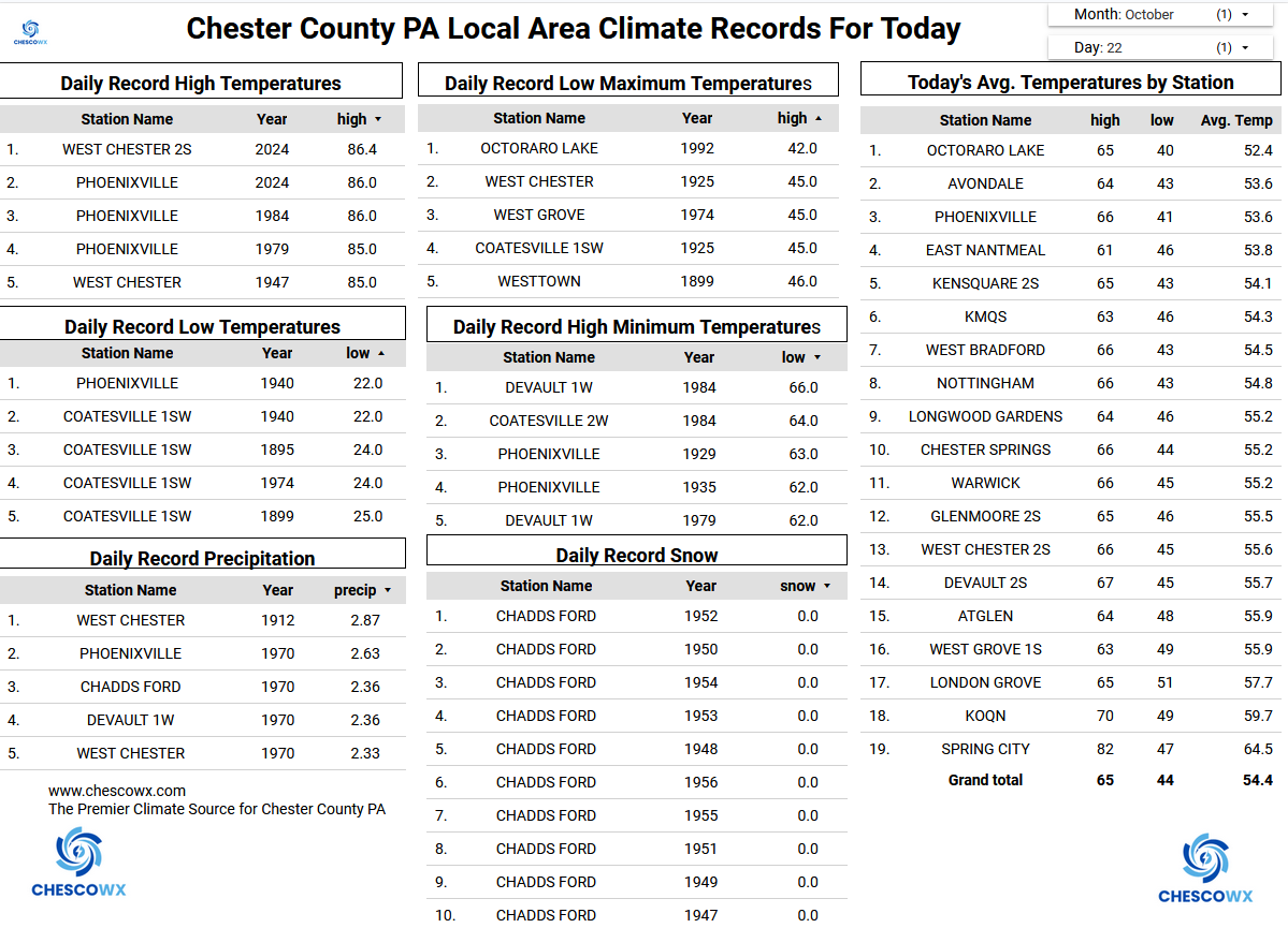
Central PA Fall Discussions and Obs
ChescoWx replied to ChescoWx's topic in Upstate New York/Pennsylvania
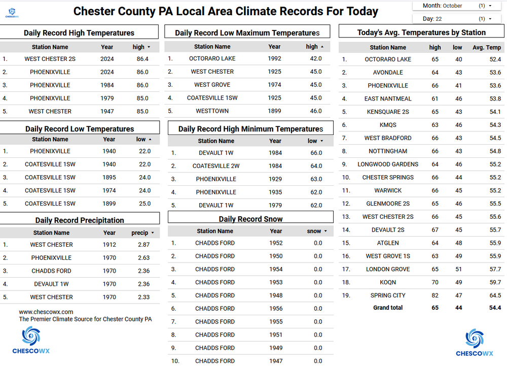
Most spots across the area saw between 0.10" to 0.22" of rain last evening through the overnight hours. With that frontal passage last night, we will turn back to below normal temperatures for much of the rest of the week and likely to finish the month of October. This means we will probably finish October with below normal temperatures. This would be our 5th below normal temperature month over the 1st 10 months of 2025. Our valley locations will likely see another freeze each morning between Friday and Sunday. The higher ridge spots (above 600 feet ASL) will likely see no more than some patchy frost and continue their growing (freeze free) season into November. The growing season has ended for most valley locations across our area. We look dry for at least the next week.
-
E PA/NJ/DE Autumn 2025 Obs/Discussion
ChescoWx replied to PhiEaglesfan712's topic in Philadelphia Region
I think I am the only one who posts here every day....no doubt winter weather will bring the folks back home!! -
2025-2026 ENSO
40/70 Benchmark replied to 40/70 Benchmark's topic in Weather Forecasting and Discussion
I think the primary impact will be to ensure this event remains pretty east-based heading into winter...it's been exceedingly difficult to marry any subsurface cold to substantive trades over the western flank. -

Spooky Season (October Disco Thread)
Damage In Tolland replied to Prismshine Productions's topic in New England
.53 needed it for the Winterizer fert I dropped yesterday. Was worried a Steining -
2025-2026 ENSO
40/70 Benchmark replied to 40/70 Benchmark's topic in Weather Forecasting and Discussion
Yea, that was a blast- -
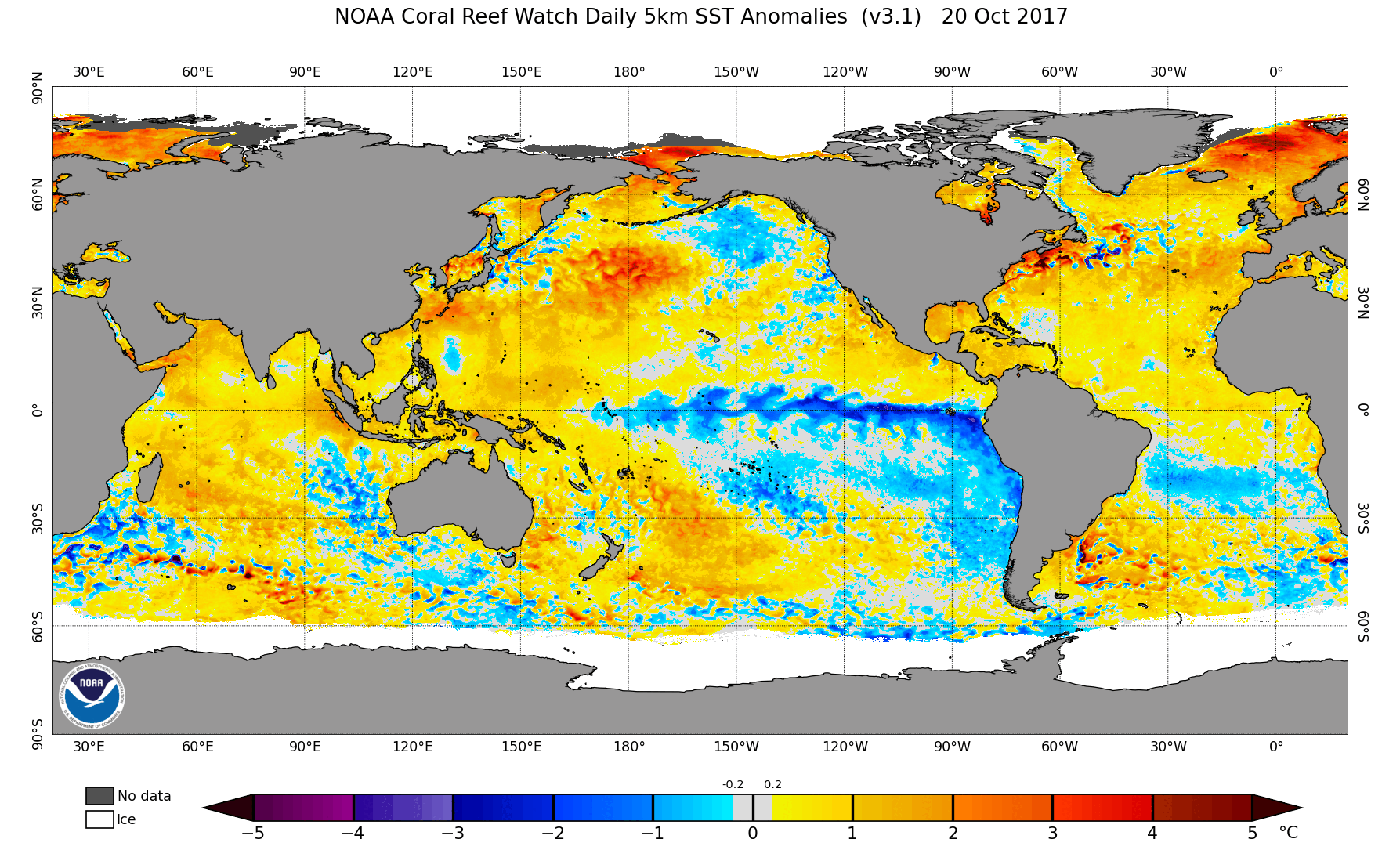
Occasional Thoughts on Climate Change
Typhoon Tip replied to donsutherland1's topic in Climate Change
https://phys.org/news/2025-10-super-arctic-climate-weather-extremes.html -

Spooky Season (October Disco Thread)
Ginx snewx replied to Prismshine Productions's topic in New England
.65 Drove in under the torrential squall at 5 am -
One of the main offenders causing that is excess nitrogen runoff into our waterways leading to the smelly algal blooms. Had that issue when I lived on the GSB. But natural marsh smells in a more pristine environment come with living near the shore. Most of the time it’s just in the background. More overpowering and persistent smells are usually a sign of pollution.
-
Columbia: 0.11” Tuesday night 1.08” for October
-

E PA/NJ/DE Autumn 2025 Obs/Discussion
JTA66 replied to PhiEaglesfan712's topic in Philadelphia Region
We should merge with the Sports forum since our Philly snow and sports fortunes are so similar Picked up .25” overnight, 49F. -
Man you say some dumb shit. Some of your opinions and approaches need to be discussed somewhere else. Maybe it's time to take a break from this place.
-
.05" overnight
-
55 / 54 had 0.35 overnight with the front. Dry Wed - Sun and near normal. Unsettled period 10/28 - 11/2 still to be determined where cutoff low meanders and where the heaviest rain and and any coastal should form and subsequently track. Warmup in the 11/4 period and beyond.
-

Central PA Fall Discussions and Obs
Jonesy56 replied to ChescoWx's topic in Upstate New York/Pennsylvania
I wonder what the record is for consecutive days with the same high temp? Not complaining, great hoodie weather.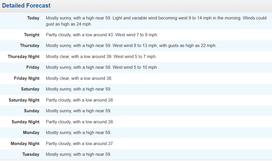
-
2017-18 honestly seems like a pretty good analog both within the tropics and with QBO having a -QBO adds more variability for the location of the aleutian high as it is more dependent on tropical forcing(-QBO favors active MJO due to increased instabillity in the UTLS b/c of cooler temps as well as enhanced cloud radiative feedbacks) in these type of +TNH cluster winters the subsurface is suprisingly weak and east based; the IPWP is currently at 150E but given the MJO expected to traverse into the pacific, it could nudge it eastward, since its already decently close to the surface, especially if it stays coupled with other seasonal waves(eq. rossby waves/kelvin waves) as it is right now in the IO. on a larger scale, it would be interesting to see if the WWB associated with the MJO pass could trigger a DKW which could start wrapping up the nina, though this would obviously take time and multiple passes and wouldn't mean anything of significance for the upcoming winter.
-

Central PA Fall Discussions and Obs
canderson replied to ChescoWx's topic in Upstate New York/Pennsylvania
47 here but only .08” rain. -

Spooky Season (October Disco Thread)
CoastalWx replied to Prismshine Productions's topic in New England
Let’s blow the chicken coops to Gene’s house. -
Just had a downpour and pretty good hail here in miller place. Like a nice quick summer storm popped up out of nowhere.
-
Spooky Season (October Disco Thread)
dendrite replied to Prismshine Productions's topic in New England
Keep that for AEMATT. I’d like my rain to touch ground and not be horizontal. -
Spooky Season (October Disco Thread)
CoastalWx replied to Prismshine Productions's topic in New England
There’s some CAPE out there. Some TCU. Let’s get some thunder.