All Activity
- Past hour
-
+1 Currently have a departure of +1.2 for this month so far, as of May 18th, but the upcoming cooler than normal stretch this week into next week would make May the coldest month of Spring 2025 by the time the month is over.
-
Probably picking the wrong time for that in the Elwood area. Monday Partly sunny, with a high near 70. East wind 6 to 8 mph. Monday Night Isolated showers before 8pm, then showers likely and possibly a thunderstorm after 2am. Mostly cloudy, with a low around 50. East wind 10 to 14 mph, with gusts as high as 23 mph. Chance of precipitation is 70%. New rainfall amounts of less than a tenth of an inch, except higher amounts possible in thunderstorms. Tuesday Showers, with thunderstorms also possible after 2pm. High near 62. East southeast wind around 16 mph, with gusts as high as 24 mph. Chance of precipitation is 100%. New rainfall amounts between three quarters and one inch possible. Tuesday Night Showers and possibly a thunderstorm. Low around 55. East wind 8 to 11 mph becoming south after midnight. Winds could gust as high as 18 mph. Chance of precipitation is 80%. New precipitation amounts between a quarter and half of an inch possible. Wednesday A chance of showers, then showers likely and possibly a thunderstorm after 2pm. Mostly cloudy, with a high near 61. West wind 9 to 15 mph, with gusts as high as 22 mph. Chance of precipitation is 60%. New rainfall amounts of less than a tenth of an inch, except higher amounts possible in thunderstorms. Wednesday Night Showers likely and possibly a thunderstorm before 8pm, then a chance of showers. Mostly cloudy, with a low around 46. Northwest wind 9 to 13 mph, with gusts as high as 18 mph. Chance of precipitation is 60%. Thursday A 20 percent chance of showers. Partly sunny, with a high near 59. North northwest wind 10 to 15 mph, with gusts as high as 21 mph. Thursday Night Partly cloudy, with a low around 43. West northwest wind 7 to 11 mph, with gusts as high as 18 mph. Friday Mostly sunny, with a high near 62. Northwest wind 9 to 14 mph, with gusts as high as 21 mph. Friday Night Partly cloudy, with a low around 44. Saturday Mostly sunny, with a high near 67. Saturday Night Partly cloudy, with a low around 46. Sunday A 20 percent chance of showers. Mostly sunny, with a high near 69.
-
This is a historic tornado that just hit Plevna KS, already seeing homes leveled - not sure how much of Plevna was destroyed as reports are showing mainly the west part was hit. Apparently the gtg got to 250mph just before hitting. What is it with night time monsters this year? Every event.
-
Emulate this...
-
Yeah I've seen that on a couple streams, fwiw I've seen less lightning the past hour or so than earlier when the cell was nearer greensburg
- Today
-
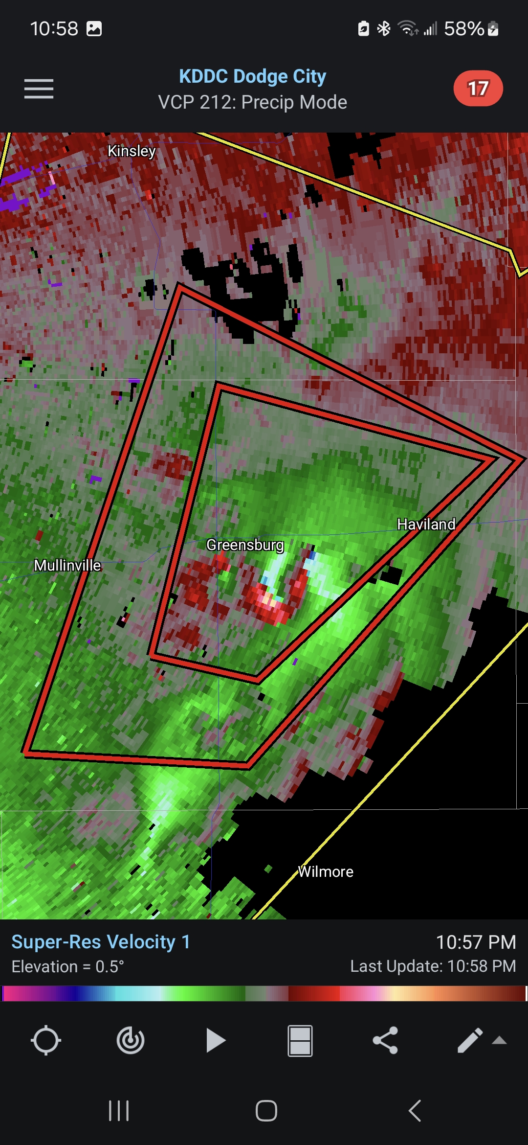
It’s wild tracking the correlation coefficient about 2 miles wide wobbling like the eye of a hurricane.
-
Peculiar since there is so little lightning illuminating the tornadoes themselves til recently when this monster spun another wedge that was seen a few mins ago. As of 11:38pm CDT, the gtg is 210mph!
-
We aren't seeing any sustained high heat and humidity until at least mid-June, which, at that point, is kind of climo for SNE anyway. I think we will get our share of swamp ass days but mostly 80's not 90's. Lame severe season and then lame tropical season is a general rule. I'm not an ACATT guy. I like a warm summer and warm summer nights, just not extended periods of gross humidity. However, I guess I'm probably one of the few here, that is fine with sub-zero temps in the winter with no snow on the ground. Weather is fun, enjoy what you get.
-
I'd like to place an order for this upcoming week to finish out the month please
-
Was in Greensburg earlier staging. Ended up dropping farther south for the daytime stuff, but headed to Wichita for the night and the cloud to cloud lightning that cell is throwing off is insane. Just constant bolts, wish I could get a good video
-

May 17th-20th severe weather discussion
Chinook replied to Chinook's topic in Central/Western States
a new tornado has formed south of Greensburg. The tornado that just missed Greensburg has been large -
May 17th-20th severe weather discussion
Chinook replied to Chinook's topic in Central/Western States
Here is the high rotation south of Greensburg a half hour ago, with some TDS visible -
That doesn't look good

-
https://x.com/IsaacWx_/status/1924296288197087657 That's one big tornado
-

May 17th-20th severe weather discussion
snowlover2 replied to Chinook's topic in Central/Western States
Tornado Warning KSC097-190330- /O.NEW.KDDC.TO.W.0009.250519T0248Z-250519T0330Z/ BULLETIN - EAS ACTIVATION REQUESTED Tornado Warning National Weather Service Dodge City KS 948 PM CDT Sun May 18 2025 ...TORNADO EMERGENCY FOR GREENSBURG... The National Weather Service in Dodge City has issued a * Tornado Warning for... Northeastern Kiowa County in south central Kansas... * Until 1030 PM CDT. * At 947 PM CDT, a confirmed large and destructive tornado was observed near Greensburg, moving northeast at 30 mph. TORNADO EMERGENCY for GREENSBURG. This is a PARTICULARLY DANGEROUS SITUATION. TAKE COVER NOW! HAZARD...Deadly tornado. SOURCE...Weather spotters confirmed tornado. IMPACT...You are in a life-threatening situation. Flying debris may be deadly to those caught without shelter. Mobile homes will be destroyed. Considerable damage to homes, businesses, and vehicles is likely and complete destruction is possible. * The tornado will be near... Greensburg around 955 PM CDT. PRECAUTIONARY/PREPAREDNESS ACTIONS... To repeat, a large, extremely dangerous and potentially deadly tornado is ongoing. To protect your life, TAKE COVER NOW! Move to an interior room on the lowest floor of a sturdy building. Avoid windows. If in a mobile home, a vehicle or outdoors.. Move to the closest substantial shelter and protect yourself from flying debris. Tornadoes are extremely difficult to see and confirm at night. Do not wait to see or hear the tornado. TAKE COVER NOW! && LAT...LON 3751 9939 3773 9932 3767 9904 3749 9928 TIME...MOT...LOC 0247Z 221DEG 25KT 3753 9931 TORNADO...OBSERVED TORNADO DAMAGE THREAT...CATASTROPHIC MAX HAIL SIZE...2.00 IN -
Agree. If we can avoid a lot of rain, outdoor activities, other than beach related things, can still go on. Hiking, golfing, bike riding are all good in cool, dry weather.
-
Its just easy to frame it around two major holidays. Also, the amount of daylight contributes to the feel of summer or not. A lot more daytime to work with in June than mid to late August. Most colleges and some schools start in Aug, and places start to lose their seasonal employees too. There's only so much potential time to the summer window, cant afford to sacrifice any just because the early parts may not be reliably hot. But I get it, in terms of beaches in this region I don't get too excited about it until July, mainly because of water temps.
-
OT but Tornado emergency for Greensburg,Kansas. Same place that got hit by an F5 back in 07 I believe it was. Geez.
-

May 17th-20th severe weather discussion
Powerball replied to Chinook's topic in Central/Western States
Tornado Warning for Denton/Collin Counties right now with that long-track supercell. It's only radar indicated for now. Also, a separate Severe Thunderstorm Warning for destructive winds (80 MPH) just went out for the same cell. It should slip by just to my north though. -
Tornado emergency for Geensburg.
-
So there is a confirmed large wedge tornado heading towards Greensburg KS, north movement, at night, also in May - WTF!?
-
Couldn’t be any different than last year. Last two weeks of May into first few days of June were generally amazing. Went to Newfound lake last few days of May into June and it was legit a mid summer feel.
-
Not great, but if it’s dry, You’ll have shots at 65-70
-
Also, add in that the area it had originated from had missed out on activity with the event on the previous day. With the resurging dry/drought conditions lately, it just happened to be a perfect situation that the severe t'storm activity had collapse in that exact area.
-
May 17th-20th severe weather discussion
Chinook replied to Chinook's topic in Central/Western States
Today, we saw some widely-spaced intense tornadoes, but not a lot happened in the mid-Kansas area that was most highlighted, as all tornado reports are a long way from Wichita. Tomorrow's outlook has an enhanced outlook for hail, wind, and tornadoes


.thumb.png.4150b06c63a21f61052e47a612bf1818.png)