All Activity
- Past hour
-

“Cory’s in NYC! Let’s HECS!” Feb. 22-24 Disco
Kitz Craver replied to TheSnowman's topic in New England
For the love of god please don’t be a head fake -
Waiting for the Euro/anything else to jump on. What a tough forecast.
-
'The Waiting' (is the hardest part) by Petty is appropriate as well... 35F/Rain
-
How much rain are we getting this weekend?
-

Feb 22nd/23rd "There's no way..." Storm Thread
snowfan replied to Maestrobjwa's topic in Mid Atlantic
WPC Discussion: ...Central Appalachians and Mid-Atlantic...Day 3...*** Nor'easter develops off Mid-Atlantic Coast late Sunday withimpacts in the Northeast through Monday ***Complex phasing is expected to result in coastal low developmentoff the Mid-Atlantic coast later Sunday with rapid intensificationas it shifts northeast Sunday night/Monday. Guidance is somewhatcoming into consensus with a surface low track east of where theGFS and west of where the EC have been. The preferred track remainswith the EC-AIFS which the 00Z run did nudge south a bit for Sundaynight. The extent of the precip shield will be critical to heavysnow banding on the NW/W side of the low. Non-uniform precip shielddepiction from guidance such as the EC is likely given the complexinteraction of mid-level and low level low centers. The Day 3 snowprobs for >6" are 40-60% for central MD through southeast PA,southern NJ and much of the Delmarva Peninsula. The rapid lowdevelopment and approach of rather strong surface high pressureto Ontario will lead to a sprawling wind field over the easternU.S. which will enhance snow impacts under heavy TROWAL bands.Please stay tuned for further details.The greater confidence is for upslope snow on the centralAppalachians in NW flow on the back side of the system Sundaynight. Great Lakes moisture encounters the topographical lift withDay 3 snow probs for >6" 40-80% above about 1500ft to the AlleghenyFront in WV and far western MD.Jackson -
All 3 of those tighten the system and because of the cleaner phase keep the good qpf well south and east though. Not sure we want a clean phase unless it happens alot sooner and farther NW. If you want the possible big dog then yes, full clean phase. If you want guaranteed low end SECS then roll the dice with more separation and the PVA precip followed by the ull/ivt stuff. What i dont like about the full clean phase is we increase the chances significantly for a rug pull last minute. Tho i suppose thats the chance we take when rooting for a big dog always.
-
Not the Poke at something while it's down, but I generally ignore them as well... but i still don't buy the GFS
-
6z Ukie big time improvement as well
-
6z Ukie big time improvement as well
-

Feb 22nd/23rd "There's no way..." Storm Thread
Weather Will replied to Maestrobjwa's topic in Mid Atlantic
We wait for Dr. No:
-

“Cory’s in NYC! Let’s HECS!” Feb. 22-24 Disco
Great Snow 1717 replied to TheSnowman's topic in New England
At this point BOX seems to be completely ignoring the GFS ... -

Feb 22nd/23rd "There's no way..." Storm Thread
AmericanWxFreak replied to Maestrobjwa's topic in Mid Atlantic
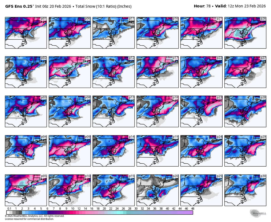
P7 and P26 on the rocks please . -

“Cory’s in NYC! Let’s HECS!” Feb. 22-24 Disco
CoastalWx replied to TheSnowman's topic in New England
This winter has been exhausting lol. Between hoping for things to work out because the last several have sucked, to the big one actually working out in late January, to the ones that did not work out, and now this lol. Woof. -
Seeing the icon/nam/rgem have a cleaner phase at 6z is extremely encouraging for sure
-
I mean I’m just floored that it’s like 5 or 6 runs in a row that the GFS is straight up locked in. Again I haven’t seen a model do that as an outlier since the NAM with Jonas in Jan 2016. GFS will eventually come to its senses and at that point should be taken behind the woodshed, but holy crap is that fun to watch
-
Let's be real, this is only less than a 6 hour timing difference wrt the 2 shortwaves between being a GFS tucked bomb or a NAM March 2001 rug pull. I will forever have ptsd from that storm and I am getting similar vibes. I am strongly urging cautious optimism from everyone because 1) we still dont have unanimous agreement 2) if the euro isnt biting its probably right and 3) always go with the least snowiest model. Not trying to deb, but alot of us, especially me included, can let emotions take hold. GFS doubled down again but could it be completely wrong and the slp escape east? You better believe that scenario is possible. Ive seen the gfs hold until 12 hours prior before....it can be stubborn.
-

Feb 22nd/23rd "There's no way..." Storm Thread
Solution Man replied to Maestrobjwa's topic in Mid Atlantic
Lots of major hits in there, I choose 26…beat down for all -
.thumb.jpg.6a4895b2a43f87359e4e7d04a6fa0d14.jpg)
Central PA Winter 25/26 Discussion and Obs
Yardstickgozinya replied to MAG5035's topic in Upstate New York/Pennsylvania
This mornings write up from Nws forcast discussion on this weekend’s winter potential. KEY MESSAGE 3: Reminder that it`s still winter with potential for accumulating snow Sunday followed by a brief cold spell with brisk winds Monday and Tuesday. Main chance for snow on Sunday would be more from the inverted trough, still a ways out to pinpoint location and amts of snow with such a feature. Upper level low dynamics might be the key for our area as well. Earlier discussion below. There remains a strong potential for a low pressure system off the Mid-Atlantic coast Sunday intensifying into a nor`easter by Monday. However, the track of the low remains uncertain with plenty of variability in the model guidance. The ECMWF and the UKMET remain farther south and offshore as it exits the coast, whereas the GFS is closest and has the greatest impacts to the Mid-Atlantic region. This is a low confidence forecast at this time with northern and southern stream phasing differences still to be resolved. It seems that even with a more suppressed and eastward track, the associated upper trough and inverted trough axis may be able to provide sufficient forcing/lift to produce a broad area of accumulating snow. Confidence in accumulating snowfall continues to increase, but significant details remain TBD as it relates to the potential for significant snowfall. Confidence is much higher in a reality check back to winter temperatures as a brisk northerly wind behind the departing nor`reaster directs a much colder Canadian airmass back into the region. Max temps on Monday and Tuesday will be 5 to 15 degrees below the historical average. The cold spell won`t last long with a moderating trend commencing through midweek as low level winds turn more southwesterly. Todays full discussion below https://forecast.weather.gov/product.php?site=CTP&issuedby=CTP&product=AFD&format=CI&version=1&glossary=1&highlight=off -
-
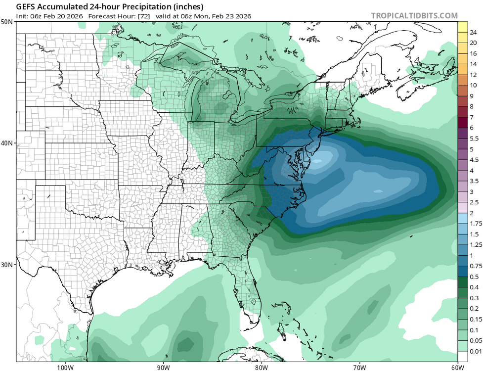
Feb 22nd/23rd "There's no way..." Storm Thread
Weather Will replied to Maestrobjwa's topic in Mid Atlantic
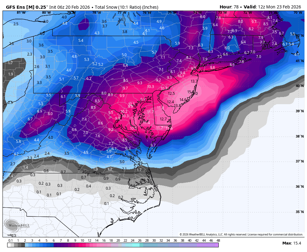
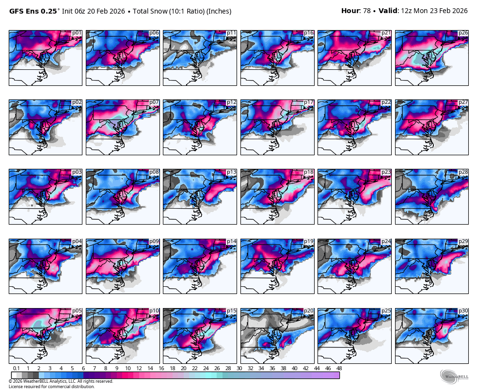
WB 6Z GEFS
-
It's trying It's best to suck our nay sayers in... don't bite yet lol
-
Finally warmed just enough here to clean up the driveway. Had a Kid slam his dodge Dakota into the side of our house early last week at 1:30 a.m...DUI. Launched 25 feet airborne, upside down over the neighbors driveway, slide on the roof through his yard and take out a huge arborviete. The tree flipped his truck back on the wheels and landed against our house in our driveway. The amount of shit from his truck left behind was a mess! Luck the house has little damage except siding
-
-

Feb 22nd/23rd "There's no way..." Storm Thread
Herb@MAWS replied to Maestrobjwa's topic in Mid Atlantic
And it t ain’t over until the fat lady sings. -
I was wondering where tf you got to