All Activity
- Past hour
-
 are you are the yankee game?
 -
 Hope it makes it I don’t wanna water the plants
 -
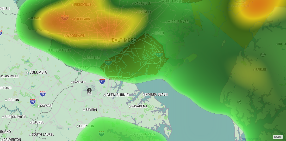
The severe weather threat is low. does not look low to me..vivid lightning and loud thunder here in manhattan..
-
 Finally a halfway decent thunderstorm around here.
 -
did not see any forecast on tv or nws ..
-
 Super loud thunder here at Yankee stadium
 -
Wow! Home Davis 1.72" so far ...backyard under water in spots...
-
hit after hit! lfg
-
 Hyperbole much? Wow. Subways have seen MUCH worse. But glad you enjoyed the storm
 -
 715 PM EDT Wed Aug 13 2025 The National Weather Service in Upton has issued a * Flash Flood Warning for... Southeastern Essex County in northeastern New Jersey...Hudson County in northeastern New Jersey... * Until 915 PM EDT. * At 715 PM EDT, Doppler radar indicated thunderstorms producing heavy rain across the warned area. Between 1 and 1.5 inches of rain have fallen. Additional rainfall amounts up to 1 inch are possible in the warned area. Flash flooding is ongoing.
 -
severe thunderstorms was not predicted by anyone for nyc.. nws not doing there job..,
-
-
 White Plains picked up 1.12" of rain in the past hour.
 -
It’s still dusty out. And the humid is like Panama.
-
Yep get ready
-
Here in Greenville, N.C. the temperature has been in the 80s for several days which would normally be nice but the humidity, omg! Scrolling through the airport data the RH has been pegged at 100% for almost every 20 minute reading with the lowest humidity in three days (as far back as the data goes) at 94%. Heat index today reached 101F. When do we get a break?
-
Was just going to say that, quite the light show here as well, very rare Nashua gets in on the action, seems these lines just keep coming towards us....we take!
-
Thats because there was no watch or slight risk
-
Seriously?

-
That’s what we had . Prolific lightning but almost no rain . First time I’ve experienced that
-
 Top 10 thunderstorms ever! This was BEAUTIFUL. Sad there were no 'nados.
 -
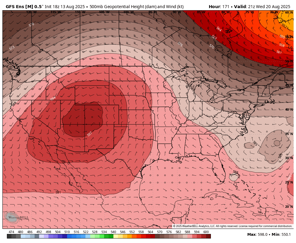
WB 18Z GEFS is still off the coast. As long as the trough along the east coast has a positive tilt, it is not coming ashore.
-
 I’m down in port Newark. This one was bad.
 -
I don't have a gauge but probably around .25" here. Not sure we get any more unfortunately, but vivid light show ongoing