All Activity
- Past hour
-
Absolutely. Sleet always makes its way further north than expected. There are a few exceptions but with another north trend, NYC’s totals will be cut back quite a bit I’d think
-
not doubtful. writings on the wall with this one. congrats albany and western new england.
-
yup. feb 8 2025. among many others. swfes arent good for our metro area, they're better for new england. underestimate the warm tongue at your own peril
-
Yikes
-

Central PA Winter 25/26 Discussion and Obs
Jns2183 replied to MAG5035's topic in Upstate New York/Pennsylvania
Gfs says get ready for true ice storm Sent from my SM-S731U using Tapatalk -

White Christmas Miracle? December 23-24th
The 4 Seasons replied to Baroclinic Zone's topic in New England
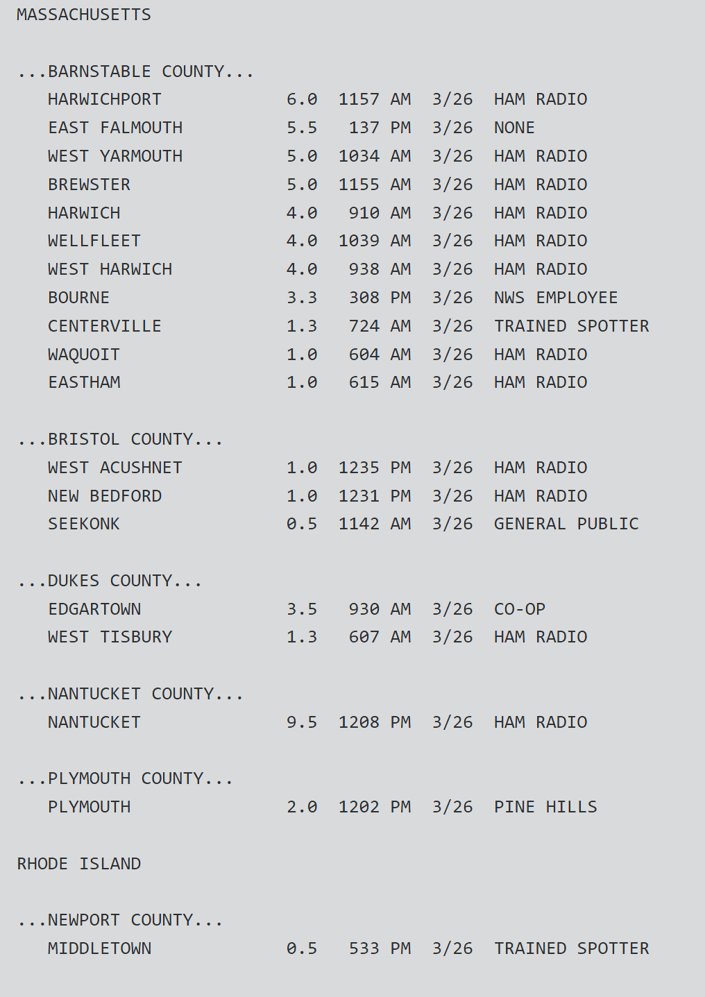
yea. ill do a map for it eventually but i didnt include it in the archive since 3"+ amounts were confined to the cape and islands. They were supposed to get much more there too but still did ok
-

December 2025 Short/Medium Range Forecast Thread
John1122 replied to John1122's topic in Tennessee Valley
The Canadian keeps the subzero cold. The GFS lays down some anafrontal snow on Monday now with that cold front passage. -
Last minute north bump on a SWFE type system- color me shocked. I think from the city east has enough wiggle room here to hold on but I’d be sweating if I was south of say New Brunswick to Trenton.
-
Idk maybe during that one frame the mid levels just really juice TF up.
-
Comes in as the 6th closest match. Closest according to CIPS is 12/14/95, overall this setup has more of the NW-SE dive though, 1995 the low tracked well north so the results of that to me are not a good match. 12/19/79 looks like by far the closest match on track but this system is more juiced and more broad. https://www.meteo.psu.edu/ewall/NARR/1979/us1219.php
-
Can’t have too many north shifts or sleet will be up to NYC. Looks like an initial heavy thump regardless. Big sleet and ice storm south of there. Doesn’t look to be any rain unless you’re south of Philly
-
Weather models are absolutely getting worse. I don’t give a crap what anyone tries to tell me.
-
-

White Christmas Miracle? December 23-24th
TauntonBlizzard2013 replied to Baroclinic Zone's topic in New England
Was March 14 where we had that epic storm bail last minute? If I remember it still got the cape and buried Atlantic Canada. -
I'll go out on a limb and say that I expect a pretty wet period for a lot of the West in January. I believe that's part of the transition out of the current pattern. CFS is pretty wet nationally for the US - something like 2/3 of the country is depicted as wetter (and warmer) than last January currently.
-
Ukie is wonky. Showing sleet to NH
-
-
Shifted a bit north but pretty much noise.
-
It also went insanely north with yesterday's event at about 48-60 hours out too. Given nothing else at 00Z did that I'd not really change any ideas yet. The RRFS/RGEM at this range have recently tended to have slight suppression/amped biases respectively so something near what the GFS shows is what I'd go with now
-

Winter cancelled/uncancelled banter 25/26
Santa Claus replied to Rjay's topic in New York City Metro
bird strike just took out Cupid and Prancer, i’m losing altitude rapidly -
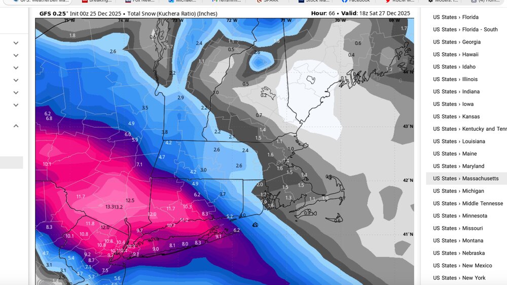
GFS Kuchera
-
I would ignore the NAM. It does whacky things like this sometimes. When the GFS is much colder, snowier and has support from the Rgem and others, it’s a great sign for snow lovers.
-
-

26th-27th event, coming at us like a wounded duck.
weatherwiz replied to Go Kart Mozart's topic in New England
Just have to hope we remain with positive trends at 12z -

26th-27th event, coming at us like a wounded duck.
Ginx snewx replied to Go Kart Mozart's topic in New England
Lol turds away