All Activity
- Past hour
-
It seems almost a certainty at this point that Melissa reaches 79W. I wonder if the close proximity to the mountainous terrain in Jamaica is somehow impacting the steering flow.
-

2025-2026 Fall/Winter Mountain Thread
Buckethead replied to Buckethead's topic in Southeastern States
The high here was 39 around 3:30, back down to 38 currently. Sent from my SM-S908U using Tapatalk -
Aside from the storm already being.2 degrees further west than the 5 pm advisory, it sure looks to be moving faster than 3 mph, too.
-
I'm late, but I was going to say that in a situation like this I think it's prudent for the NHC to wait until recon is there and collecting data to update intensity. They kind of got burned earlier in Melissa's intensification by declaring an intensity that was a little higher than obs showed (but still in the ballpark using the info they had at the time), and there's no reason to speculate this close to landfall. From Treasure Beach to West End is right about 50 miles as the crow flies. Pretty much my second rule of chasing is no Island Roulette as Josh calls it because there's always the risk that the center will wobble enough to miss a landfall (which to be clear to everyone reading, would be awesome here). The problem here is the sharp turn. We've seen many a storm that once they start hooking poleward, they can lean hard enough into a NE heading that it changes a projected landfall zone. With Melissa gaining latitude now, I think it'll be extremely difficult to avoid a landfall.
-
Still some differences in the evolution and track across guidance. Go with the blend.
-
That it’s a possibility now is quite shocking. These wobbles we’ve been watching for days now have extreme meaning given 2/3 of Jamaica is now probably too far right to be reasonably at threat for a direct landfall. I’m not saying it will miss but NHC explicitly has it heading NNE now on its track and it has definitely dipped due west. It will not take much more at all to miss entirely
-
I will say if this gets to about 79W it would have the chance to miss wide left given the forecast angle of recurve
-
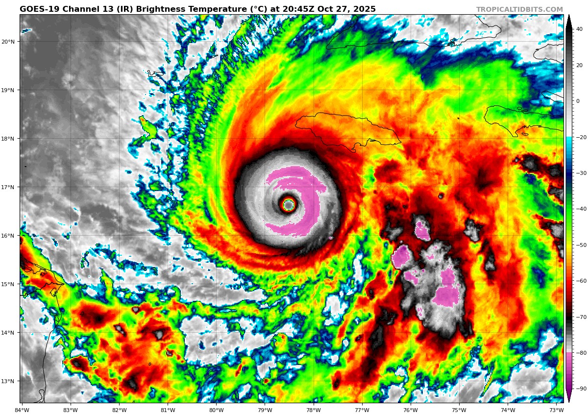
Looks to be the strongest she has been yet. What an unbelievable IR image.

-
It looks like a supercane. It does seem to be still wobbling west. It might spare the eastern part of the island. If it can push west just a little bit more it might spare most of the island.
-
I mean per the 5 pm track, it could track within (to the West side) the cone and the center could still miss landfall West of the island, so per the NHC it is well within the realm of possibility
-
That is a really good thing. The further west it goes, the less the key population areas like Kingston get hit - with wind and rain. Go West, young storm, go West.
-
Is there a chance this thing misses Jamaica? Like I know no model shows it and it would be an epic modeling fail of even more epic proportions but dang if this doesn’t keep dragging further west when everything has it riding N or NE now
-
-
They kept it at 175mph. However the discussion says the inbound aircraft might find Melissa stronger than 150kts.
-
They held it at 150kts for the 5pm.
-

Spooky Season (October Disco Thread)
mreaves replied to Prismshine Productions's topic in New England

-
Still moving due west for the most part.
-
My Goodness! What a collapse .........................
-
Latest Dvorak estimates are in the 165 to 170kts neighborhood. I bet we get 160kts at 5pm.
-
I believe Milton did as well when it peaked.
-

Correlation of extreme hurricanes, AGW, and solar cycles
Roger Smith replied to WolfStock1's topic in Climate Change
The anti-correlation idea may have come from 2004-05 which does not fit the theory. I noted in the hurricane Melissa discussion that 1780, a very bad year in the Caribbean, was also two years after a large solar peak in 1778, and the Long Island express (1938) while not a cat-5 was a year after a solar peak. Rather active years that came before a solar peak would include 1916, 1936, 1944 and 1998, as well as 2020. 1887 is closer to a solar minimum like 2004 and 2005. 1893 was a very active tropical year and there was a solar peak in 1893-94. The least active season in recent times, 1910, came at a solar minimum. I would include Andrew on the basis of the 1989 cycle peaking rather broadly from 1988 to 1991, the "1989" designation is only barely valid, and in fact also the 1968 peak had a very well defined secondary peak in 1972 (Agnes). Perhaps if there is a correlation, it is not because the solar conditions induce stronger hurricanes to form, but because some mechanism in the solar system peaks at that time and is responsible for these two different effects. Clearly it is not a necessary condition given the number of counter-examples. But it seems relatively robust over about twenty solar cycles, before 1780 we probably don't have enough data to form any conclusions. -
On a side note, -80C cloud tops or colder have now wrapped around the Eastern 2/3rds of the CDO. Hard to remember that happening before in the Atlantic. Only other example I can recall is Dorian at peak intensity.
-
Recon has taken off, should get some more data in a couple hours
-

E PA/NJ/DE Autumn 2025 Obs/Discussion
Hurricane Agnes replied to PhiEaglesfan712's topic in Philadelphia Region
The last 2 days I had lows of 40 and 40 and this morning's low was 41. The highs were 59, 60, but cooler (so far) today at 57. I expect cloud cover was in play over the weekend. It's currently mostly sunny and 56 with dp 33. And OMFG, Melissa was at 175 mph sustained at the 2 pm update. Waiting for the next update.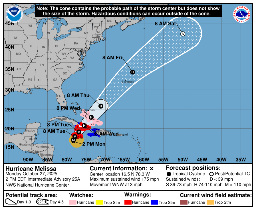
-
The mean motion is more Westerly again. I think we’re seeing an example of an intense hurricane amplifying the ridging to its North. This of course is being counteracted by the trough building into the Southeast US and making for quite the battle. I fully expect the eventual hard turn but Melissa continues to track to the West of most guidance and the official track. Even these small shifts can have major implications regarding landfall location.