All Activity
- Past hour
-
It's the canned response from the ball- washers, lacking any original thought or nuance: short-term pain for long-term gain. Hurr. Durr.
-
Stein. That is all.
-
He’s back ! https://x.com/growingwisdom/status/1953545176145965074?s=46&t=dhcbvkjmRcyBVQtDxJ3lRg
-
How has everyone’s summer gone? Outside of pretty warm conditions, it’s been one of the most bland summers from a storm perspective I’ve ever seen in the GL.
-
The pattern this year looks ripe . Reminds me of 54
-
 The remainder of the week will see temperatures average somewhat below normal. Highs will mainly be in the upper 70s and lower 80s with lows falling into the upper 60s in New York City. A new round of heat could begin to develop on Sunday. The region will likely experience a return of 90° or above heat next week. The probability of extreme heat has increased in recent days. Temperatures could top out in the middle or perhaps even upper 90s in the hot spots Tuesday through Thursday. The ENSO Region 1+2 anomaly was +0.4°C and the Region 3.4 anomaly was -0.3°C for the week centered around July 30. For the past six weeks, the ENSO Region 1+2 anomaly has averaged +0.37°C and the ENSO Region 3.4 anomaly has averaged -0.08°C. Neutral ENSO conditions will likely continue through the summer. The SOI was +16.63 today. The preliminary Arctic Oscillation (AO) was +0.560 today. Based on sensitivity analysis applied to the latest guidance, there is an implied 56% probability that New York City will have a warmer than normal August (1991-2020 normal). August will likely finish with a mean temperature near 76.7° (0.6° above normal).
 -
"Likely" is a strong call? Dry patterns are not the most conducive for New England hurricanes... Wet August and Septembers preferred in my thinking??
-
yup.. mentioned this earlier in the day. It may not feature a scalar temperature that bests late June, and recently in late July, but ends up with first place in the aggregate. Summing up 8 days straight of 91 to 95 is a greater "AHC" ( Atmospheric Heat Content ).
-
My lawn is toasted. Straw. I threw in the towel already.
-
Bye bye lawns. May be worse than last Augdewst-Novorch drought and fire season . Unless a cane makes a visit which seems likely this year
-
How are we doing on rainfall rankings?
-
Hmmm... seemed seasonably cool to me.
-
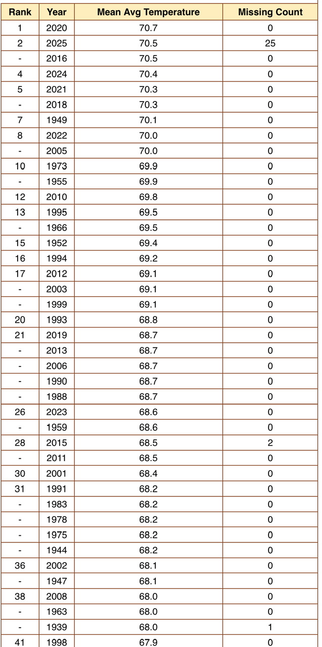
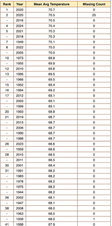
You guys have been impressive up there. I think you stand 12th for maximum mean. Connecticut is like 35th.
-
Pretty good downpour right now in downtown Balitmore
-
I saw BTV was #2 and IZG is #2 (back to 1996). Not a lot of mid level temp gradients or damming up here this summer.
-
That might be a usable excuse except for the fact that my comment was made after walking around campus here at work where it did not rain yesterday. LOL
-
We need Eric to tell us what we have been saying for 3 days?
-
Yea the over the top heat got you up there. How does that rank with Portland or say Western Maine
-
I see I could see it drops
-
Good shot for CON airport to finish #1 this summer.
-
This year I trolled Scott and Kevin with back break.. Forky stick to NY stop following me around like a petulant child.
-
That’s not what I said. You said it likely drops position from 13th. It would have to be cold enough to lower the summer average from 73.2 to 72.9. I find that unlikely.
- Today
-
https://x.com/ericfisher/status/1953537666860900518?s=46&t=dhcbvkjmRcyBVQtDxJ3lRg
-
I don't remember seeing showers moving backwards twice in the same week...seeing a cluster move east to west on radar is weird, lol
-
So you are saying the last 19 days average above 73.2 good stuff to watch.