All Activity
- Past hour
-
It was. The dramatic shift reveals the limits of the guidance beyond 10-14 days. Dramatic changes can and do occur. This time around, at least for the NYC area, the AI estimate will blow the modeling out of the water.
-
Cool period EWR: 5/19: 73 / 52 (-1) 5/20: 71/50 (-3) NYC: 5/19: 69 /51 (-4) 5/20: 67 / 49 (-6) LGA: 5/19: 70 / 52 (-4) 5/20: 68 / 50 (-6) JFK: 5/19: 74 / 53 (+3) 5/20: 76 / 50 (+1)
-
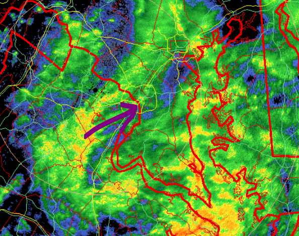
Mount Holly seems to to think later today and tonight for the Eastern and Southern areas based on forcing and other factors. We shall see. Looking at radar trends seems for my area two time periods to watch, in a few hours for the areas moving in from the West and then tonight as stated by the AFD. As the new surface low consolidates and moves north to off the New Jersey coast later tonight, the forcing for ascent should increase for a time again and this may be tied to a zone of 850 mb frontogenetic forcing to the north and west of the surface low. Depending on the strength and placement of this, a zone of heavier rain is possible. This should also result in an increase in the rain from west to east across much of the area this evening. An easterly low-level jet migrates northward across our area, especially tonight into Thursday morning, which could add to the ascent across parts of the region. Some of the rain will be heavier at times, which is when some localized urban flooding cannot be ruled out. Total rainfall amounts are forecast to be 1.0-1.5 inches across the region through the day Thursday. Some elevated instability could occur for a time especially this evening mostly south and east of Philadelphia, although it is less certain if it would be enough to result in some lightning/thunder.
-
Spotty light showers in inner moco and PGC this am. looks like a slightly brighter final band may come thru? IDK how far north though.
-
Records: Highs: EWR: 96 (1996) NYC: 93 (1996) LGA: 93 (1996) JFK: 90 (1996) Lows: EWR: 42 (2002) NYC: 40 (1907) LGA: 45 (2002) JFK: 42 (2020)^ Historical: 1860 - A swarm of tornadoes occurred in the Ohio Valley. Tornadoes struck the cities of Louisville, KY, Cincinnati, OH, Chillicothe, OH, and Marietta, OH, causing a million dollars damage. (David Ludlum) 1881: Clara Barton and a circle of close friends found the American Red Cross. 1895 - The temperature at Norwalk, OH, dipped to 19 degrees to set a state record for the month of May. (The Weather Channel) 1896 - The mercury soared to 124 degrees at Salton, CA, to establish a U.S. record for May. (Sandra and TI Richard Sanders - 1987) 1949: A violent tornado crossed the Mississippi River from the St. Louis area into Wood River, then to Roxanna. This tornado damaged or destroyed 300 homes in these two towns, killing five people. Four people died in a destroyed restaurant in Palestine, Illinois; one body was recovered from a tree. A tornado causing estimated F4 damage killed five people and injured 55 in St. Louis and St. Charles counties in Missouri and Madison County in Illinois. This tornado was part of an outbreak that produced four different tornadoes and was responsible for five deaths and 57 injuries. 1973: An intense electrical storm that moved through Tecumseh, OK which resulted in lightning "fire balls ", running along the city's power lines. Only brief power outages and minor damage were reported, except for an abandoned home that burned down after being struck by the lightning. 1980 - The temperature at Williston ND reached 102 degrees to set a record for May, and the next day the mercury hit 106 degrees. (The Weather Channel) 1987 - Severe thunderstorms, developing along a sharp cold front crossing the central U.S., produced 60 mph winds and golf ball size hail at Sedalia, MO, and drenched Hagerstown, IN, with six inches of rain in one hour. Temperatures soared into the 90s ahead of the cold front. Paducah, KY, hit 94 degrees for the second day in a row. Light snow blanketed Montana, with three inches reported at Butte. (The National Weather Summary) (Storm Data) 1988 - Severe thunderstorms swept across southern Louisiana during the morning hours spawning six tornadoes, and producing wind gusts to 88 mph at Jennings. Thunderstorms also produced five inches of rain in two hours at Lake Charles, causing local flooding. (The National Weather Summary) (Storm Data) 1989 - Thunderstorms moving southeastward across the Central Plains Region into Oklahoma and Arkansas produced severe weather through the day and night. Thunderstorms spawned just four tornadoes, but there were 243 reports of large hail and damaging winds. Baseball size hail was reported at Augusta, KS, and thunderstorm winds gusted to 98 mph at Johnson, KS. (The National Weather Summary) (Storm Data) 1990 - Thunderstorms produced severe weather across the southeastern U.S. for the second day in a row. Severe thunderstorms spawned five tornadoes, including one which injured a person at Richmond KY. There were eighty-seven reports of large hail or damaging winds, with hail three inches in diameter reported at Austin TX. Thunderstorms produced up to five inches of rain in Macon County GA, and heavy rains left nearly eight feet of water over roads near Stepstone KY. (The National Weather Summary) (Storm Data) 1992: Canadian high pressure across the Mid-Atlantic brought record low temperatures to parts of the East. The morning low of 28° degrees in Atlantic City, NJ was the coldest ever for so late in season. Locations that reported daily record lows for the date included: Martinsburg, WV: 35°, Salisbury, MD: 36°, Baltimore, MD: 38°, Dover, DE: 41°, Wilmington, DE: 41°, Washington, D.C.: 43 °F. 2001: Golfers participating in a golf tournament at the Majestic Golf Course in Hartland, Michigan received an urgent message on the G.P.S. on their carts. The message, relayed from the clubhouse, was that a tornado was bearing down on the course. Most of the golfers made it to safety in the clubhouse, although some had to take shelter on the course. Only one golfer suffered a minor injury. The F2 tornado damaged 70 cars in the parking lot along with numerous golf carts and a pontoon boat.
-
0.07" in the aforementioned Garrett County bullseye lol. Underperformer is one of the terms that comes to mind altho not the only one.
-

2025 Atlantic Hurricane Season
BarryStantonGBP replied to BarryStantonGBP's topic in Tropical Headquarters
16,9,4 and 154 ACE points = UKMO -
54 / 51 clouds. Cool / wet stretch the next 72 hours. Rain later and heavy rain Thursday with coastal as trough cuts off and ULL slowly moves through and northeast this weekend. 1.5 to 3.00 inches of rain in the heaviest spots northeast. Saturday to slowly clear out but with upper level low still over to the north some isolated showers and and stingy clouds could get in the way espeically eastern areas. Sun and Mon to look to clear out and get back to normal. Trough still into the northeast through much of next week with next chance for showers and rain 5/28 - 5/30. Warmth and heat on the move north and east out of the west and a much warmer start to next month and the chance for tracking some heat. May see the trough back west and ridge setup along the EC / WC. On to the clouds
-
Picked up 0.04" so far on my way to another, perhaps, two inch event which would easily take me over 10 inches of rain for the month.
-
Sews her own clothes and is fun at picnics.
-
Pretty close to a record low High Temp today in some spots I believe. NYC is 54.
-
This will be the storm everybody watered this winter.
-
Most guidance had the most widespread rain this morning. Certainly looks like an underperformer.
-

2025-2026 ENSO
40/70 Benchmark replied to 40/70 Benchmark's topic in Weather Forecasting and Discussion
Interesting that the Euro and Aussie have a warm neutral.....hasn't the EURO been running hot for ENSO? -
Unfortunately.
-
"The weight doesn't bother me, she has a pretty face and a beautiful heart"
-
Rise and shine, Allison
-
2025-2026 ENSO
40/70 Benchmark replied to 40/70 Benchmark's topic in Weather Forecasting and Discussion
I would still prefer a more meager El Nino....I am far enough north where I still want a good deal of N steam involvement, or it ends up occluded after a mid atl snowmaggedon. -
You have to wonder how much the EPAC needs to warm in order to offset the warming in the WPAC. While 2023-2024 was the warmest winter on record across the CONUS, at least we had that great record breaking STJ in February with the El Niño. That was a nice snowstorm in a narrow zone between NYC and Philly. Unfortunately, it didn’t extend very far from this region since it was more of a mesoscale IVT feature. My attitude is that I would much rather roll the dice with a strong El Niño and STJ influence no matter how warm to just get the storm track further south. Heck, even in March 1998 we had a better snowstorm than we have seen in recent years even though it was also a very mild winter. This persistent Niña background since 2018-2019 has shifted the storm track too far north for many of us. Monthly Data for March 1998 for Upton NY NWS CWA Click column heading to sort ascending, click again to sort descending. NY YORKTOWN HEIGHTS 1W COOP 9.0 NJ GREENWOOD LAKE COOP 8.5 NY WEST POINT COOP 8.0 NY WALDEN 1 ESE COOP 6.5 NY PORT JERVIS COOP 6.1 NJ CHARLOTTEBURG RESERVOIR COOP 6.0 NY NY CITY CENTRAL PARK WBAN 5.0 NJ WANAQUE RAYMOND DAM COOP 4.8 NJ RINGWOOD COOP 4.8 NY LAGUARDIA AIRPORT WBAN 4.7 NJ CANOE BROOK COOP 4.5 NJ HARRISON COOP 4.5 NY WEST NYACK COOP 4.5 NY MINEOLA 1 NE COOP 4.2 NJ MIDLAND PARK COOP 4.0 CT DANBURY COOP 4.0
-
had just started to sprinkle when i walked out of gym at 545
- Today
-
2025-2026 ENSO
40/70 Benchmark replied to 40/70 Benchmark's topic in Weather Forecasting and Discussion
I think given (potentially) ENSO neutral this coming season, you have weight things towards modest cool ENSO. -
2025-2026 ENSO
40/70 Benchmark replied to 40/70 Benchmark's topic in Weather Forecasting and Discussion
We need to cool off the west Pac....or at least relative to the east Pac...the ratio right now (warmer west/cool east) predisposes us to a cool ENSO paradigm...that is why we have been having problems on the east coast due to se ridges and strong jets obliterating PNA ridges. That is cool ENSO like. I think we actually agree on alot, but just emphasize different aspects and drivers. -
Nothing is about to eat us…LOL. Most people off these forums like milder and less snowy winters. This is why most people are moving to the sunbelt instead of to the cooler and snowier spots like Marquette and Caribou. I point out the changes in the Pacific Jet for the very reason that I enjoy colder and snowier weather. So in order to understand how we could potentially change up this pattern is key for winter weather fans. We have to change the Pacific side and Southeast Ridge trends in order to bring back some great winter weather here. I grew up in the 70s and had to wait at the bus stop during those little ice age throwback winters. Also fond memories of the Great 1980s into early 1990s Arctic outbreaks. So I am more a fan of cooler climates than ones that have become much warmer. I have been trying to think how we could change up the Pacific in order to bring back more of a STJ influence. Would probably involve a very potent El Niño that would be very warm. But I am fine with winter warmth provided there are great snowstorms like in 15-16, 16-17, 17-18, and 20-21.
-
At least the sun is popping out here this morning.
-
2025-2026 ENSO
40/70 Benchmark replied to 40/70 Benchmark's topic in Weather Forecasting and Discussion
Man, @bluewave that link is an absolute pants tent.....you always casually pull these elite data sources out of your rear...too bad you never use your power for good, instead of in support of trying to convince us all that the Pacfic Jet is about to eat us.


.thumb.JPG.418e8a9a2902ae687ec35ff4bc0e038e.JPG)


.thumb.png.4150b06c63a21f61052e47a612bf1818.png)


