All Activity
- Past hour
-
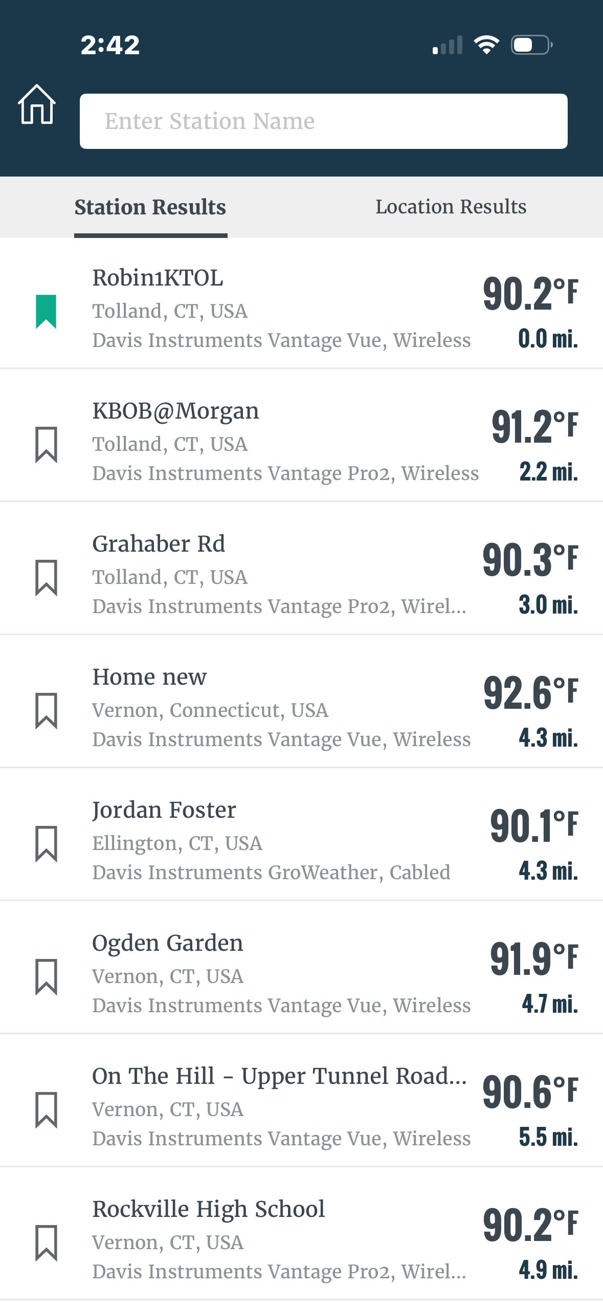
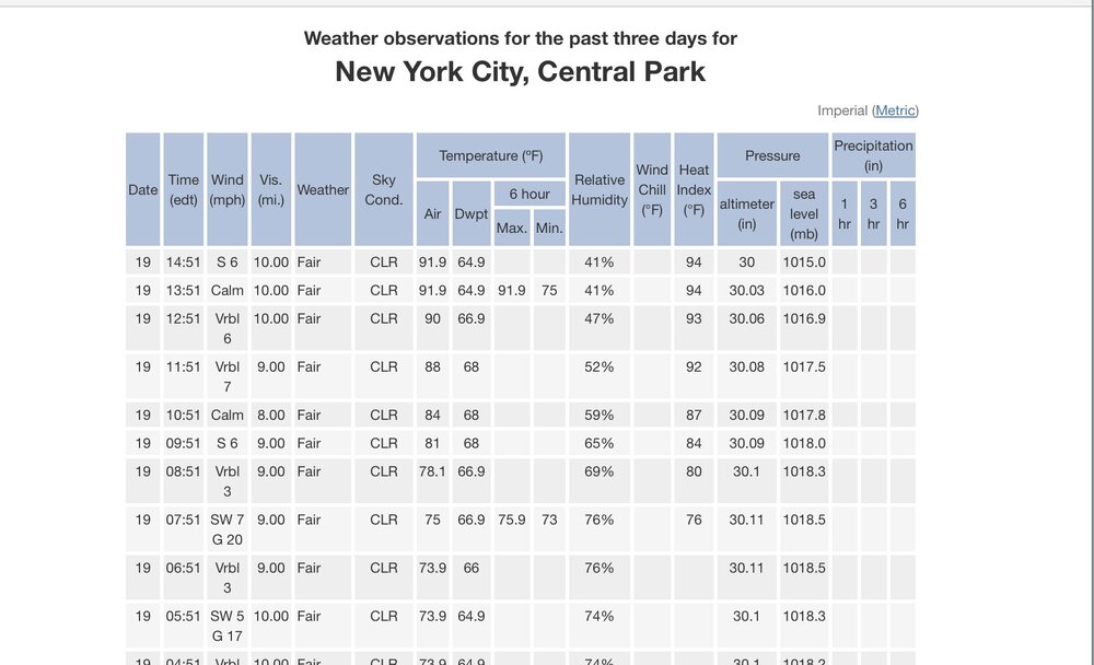
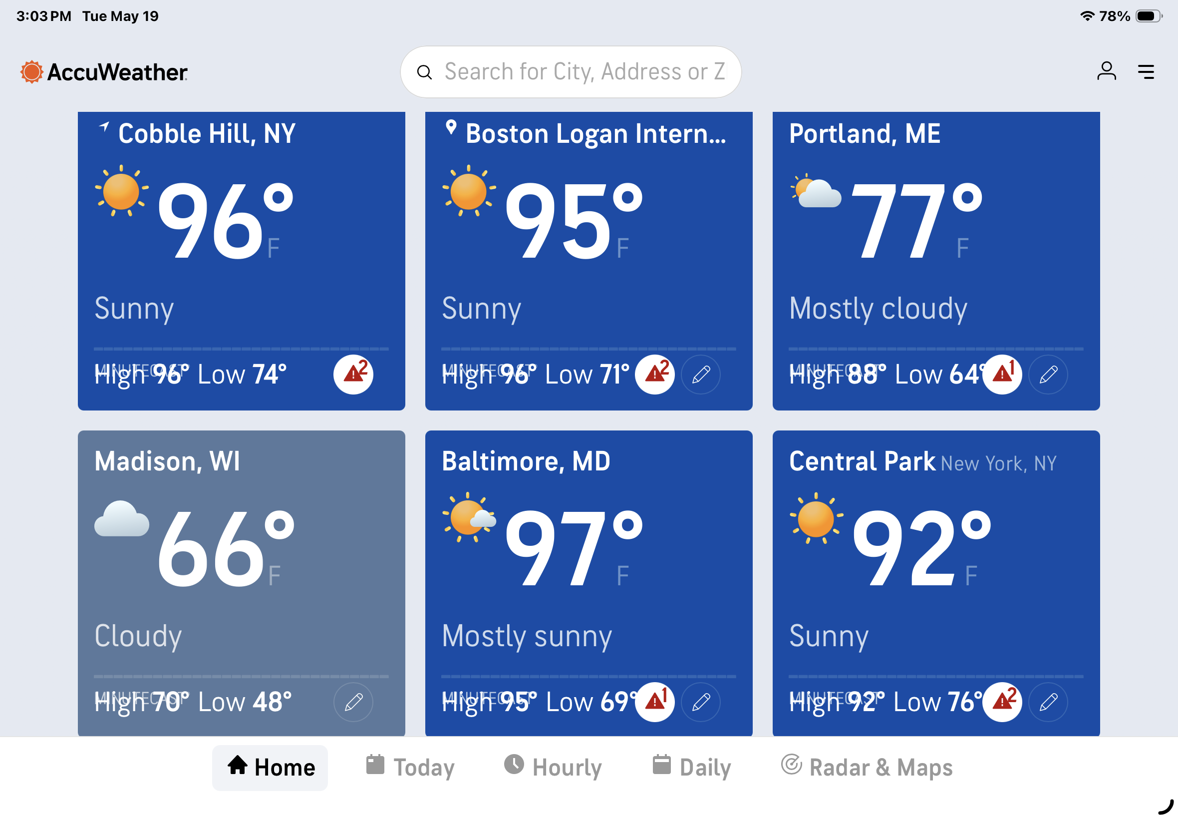
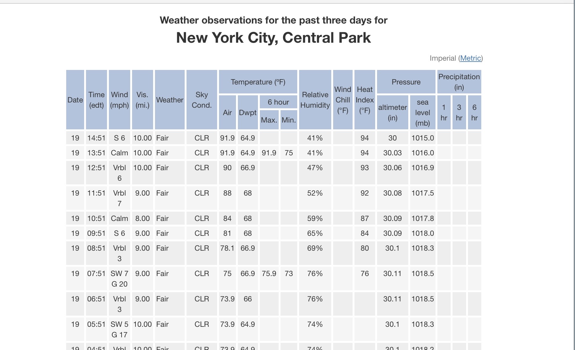
The entire city, except for eastern and south Queens is currently generally in the mid 90s! Central Park hasn't gone above 92! They were projected to be in the 95-97 range, today. Probably no other weather station in our area has underperformed today as much as KNYC has.
-
Agreed …. Why not move them? As always …..
-
My Cobble Hill/Red Hook Brooklyn NY location, 8+ miles south of the park is running warmer. As always ….

-
jokes aside, the DP's likely to rise in the ambience over night. Heat of the day and mixing/turning over the BL ..etc, cuts off and then theta-e from evaportranporation and top soil evap pools while absorbing a lot of the outgoing LR should be warmer. Urban areas will be warmest
-
Yeah rounding
-
Winds SW at Logan now so they maxed an hour ago.
-
Move the sensors in Central Park! It's going to another summer of the park running 3 to 5 degrees then the rest of the city!
-
Not here UHI over fertilizer beds only.
-
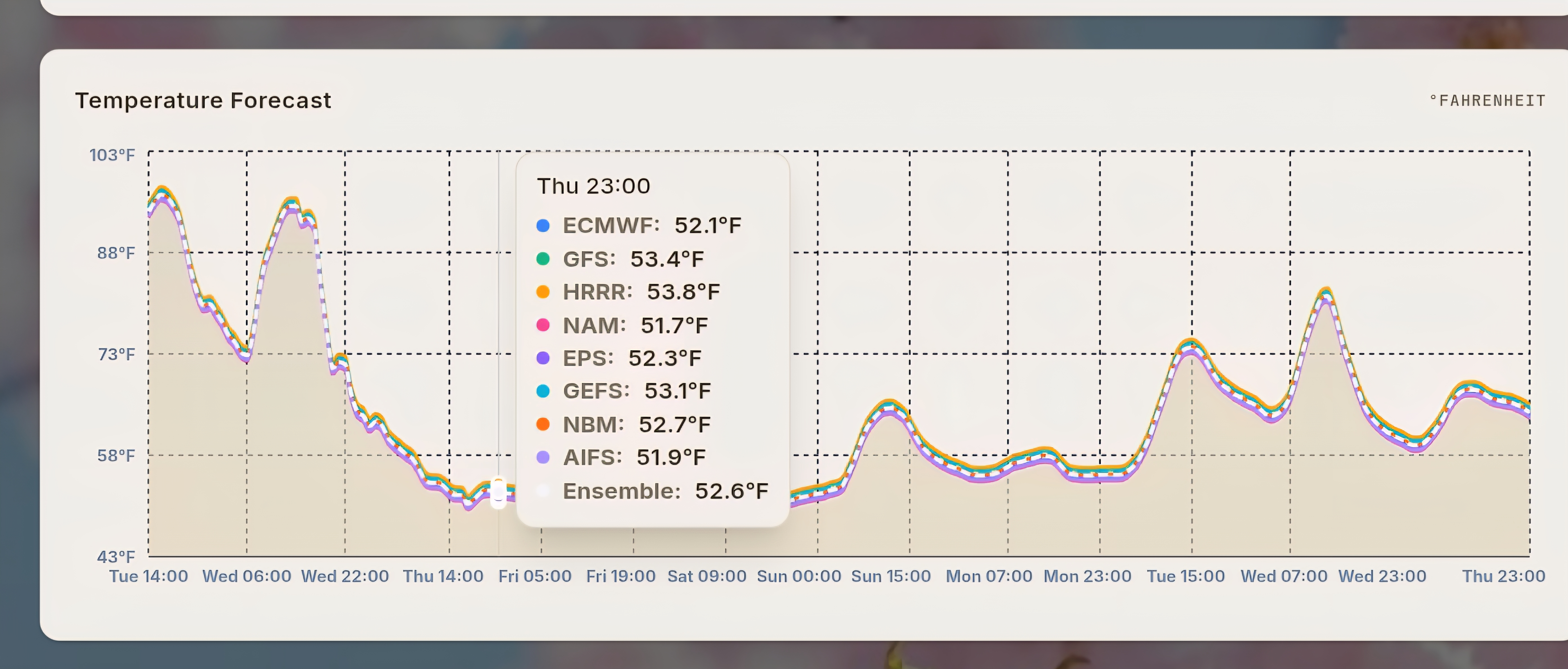
45 degree temp drop is an impressive cold front. From my super Ensemble Ginxweather.com

-

-
(002).thumb.png.6e3d9d46bca5fe41aab7a74871dd8af8.png)
E PA/NJ/DE Spring 2026 Obs/Discussion
ChescoWx replied to PhiEaglesfan712's topic in Philadelphia Region
Almost there up to 89.3 high for the day - nearby Glenmoore DEOS station at 89.8....I think we can do it today!! -
Wasn’t this the feature that nearly wrecked our 1/31 winter storm because it interrupted the gulf moisture transport?
-

2026-2027 Strong/Super El Nino
40/70 Benchmark replied to Stormchaserchuck1's topic in Weather Forecasting and Discussion
It's going to be a torch.....but we had some shots back then that just didn't pan out. If things were timed differently, we could have availed of some -NAO periods...hell, my area pulled off a great event as it was just prior to xmas. Personally, I doubt it ends up as east-based as 1997...but if we don't cool the west Pacific off, then that would be even worse because it would mean MC competition as far as forcing. If we cool the west Pacific off and get a basin wide deal, then we have a shot at something. -
For Dendy
-

2026-2027 Strong/Super El Nino
Maestrobjwa replied to Stormchaserchuck1's topic in Weather Forecasting and Discussion
But if it's gonna be east-based, though...isn't that an automatic wall-to-wall torch like 97-98? -
2026-2027 Strong/Super El Nino
40/70 Benchmark replied to Stormchaserchuck1's topic in Weather Forecasting and Discussion
Either way, we are getting a pig ridge in Canada...but we can either have a trough in the southeast, or a cool ENSO like se ridge. This why my 2023 outlook was such a dud...I didn't get that back then. -
2026-2027 Strong/Super El Nino
40/70 Benchmark replied to Stormchaserchuck1's topic in Weather Forecasting and Discussion
A pure super El Nino would offer more hope for a wintry period than the warm/cool ENSO hybrid that we witnessed in 2023 and to a lesser extent, 2015....especially early in the season. -
88 here.
-

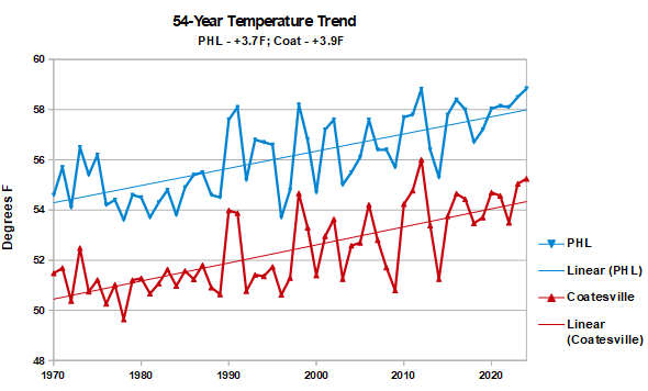
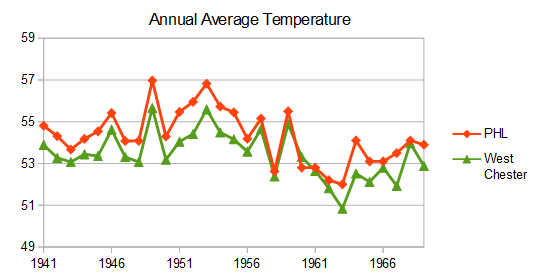
Chester County PA - Analytical Battle of Actual vs. Altered Climate Data
chubbs replied to ChescoWx's topic in Climate Change
Nope. The 95F data in Chesco and Philadelphia are in agreement. when you factor in the hot years at Phoenixville and the cooling West Chester move in 1970. Reposting my raw data plots which show the airport warming at the same rate as Chester County.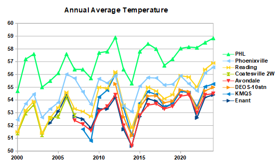
-
2026-2027 Strong/Super El Nino
Maestrobjwa replied to Stormchaserchuck1's topic in Weather Forecasting and Discussion
Why? -
Know what might happen ... the urban centers go nuclear unbearable dunnite. Dps are 59 to 66 depending on site and probable instrumentation nuances...so call it 63. But as the evening presses on, the thermal battery of the brick and crete and street's gonna be more than willing to dump its load back out - pure infrared re-bathing. And as the DP creeps up to sponge it in lock step? Ooh. I could isee it being pretty ridic in some of the downtowns, or like those 3 floor town house multi dwellers ... swimmin in sweat with gun pops echoing from distant neighborhoods. 2nd shift cops are on alert already heh
-
95/63
-
Looks like we're at the bounce temp.
-
2026-2027 Strong/Super El Nino
40/70 Benchmark replied to Stormchaserchuck1's topic in Weather Forecasting and Discussion
I think this is the first time I have every genuinely hoped you were right. -
"highs" ? interesting... ORH on NWS' W&H interface product has 90 since 1:15 pm ... Not sure about rounding this or that...


.thumb.gif.f92b16c631a1d15d405ed77b33f0710d.gif)