All Activity
- Past hour
-
Apparently there is a South Pole stratwarm event that also happened in 13-14. Long explanation at the severe weather EU site about how that could be a sign of what the pattern will be here this winter. https://www.severe-weather.eu/category/global-weather/
-
there was actually a recent research paper that came out that attributed the lack of extreme teleconnections in the 2023/24 strong/super nino to an equally, if not more anomalous warming in the tropical Indian and Atlantic oceans, which is certainly interesting to think about how this will affect how seasonal forecasts are conducted in the future https://www.nature.com/articles/s43247-025-02584-8
-
it's funny, i am planning a family gathering at the house Sunday. Based on the forecasts I have seen, i have been focusing on having an indoor event. then I wake up this morning and not a drop of rain in the forecast. weird how that works. Of course if i change my plan to an outdoor event, 100% chance it will rain
-
Impressively steep radiational cooling resulted last night. 60s above ~700 ft and present hour, while lingering 40s in some places lagging recovery underneath. FIT's bounced 20 already ... 44 --> 63andchange Looking at the NAM's grid we could be 80 to 82 later on.
-
The Mid Atlantic one is a good one, too. Though I wish this forum was as active as those two.
-
get used to that this winter ... 'Euro/GGEM collapsing toward progressivity' once we get toward mid winter, suspect a lot of pissin' and moanin' ha
-
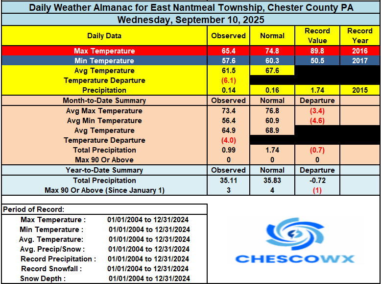
Today here in East Nantmeal should be only our 3rd above normal temperature day in the last 25 days. In fact, over the next week temperatures looks slightly above normal. While many of us did see some unexpected light rain yesterday it looks dry for at least the next week. Here in EN we are at 98% of normal rainfall through yesterday. Unfortunately, we look to add to that rain deficit.
-
(002).thumb.png.6e3d9d46bca5fe41aab7a74871dd8af8.png)
E PA/NJ/DE Autumn 2025 Obs/Discussion
ChescoWx replied to PhiEaglesfan712's topic in Philadelphia Region
Today here in East Nantmeal should be only our 3rd above normal temperature day in the last 25 days. In fact, over the next week temperatures looks slightly above normal. While many of us did see some unexpected light rain yesterday it looks dry for at least the next week. Here in EN we are at 98% of normal rainfall through yesterday. Unfortunately, we look to add to that rain deficit.
-

2025-2026 ENSO
40/70 Benchmark replied to 40/70 Benchmark's topic in Weather Forecasting and Discussion
I would still take 1995-1996 over 2014-2015....but it's close. Having the holiday season cold/snowy is the deciding factor for me. -

2025-2026 ENSO
michsnowfreak replied to 40/70 Benchmark's topic in Weather Forecasting and Discussion
Yeah for you guys 2014-15 was the winner. It was a severe winter here for sure, bitterly cold and white, but outside of one huge snowstorm Feb 1st, it was a much, MUCH quieter winter than 2013-14. -
so much for that. The Euro/GGEM collapsed pretty far toward the GFS' more progressive, less digging cold pool Sunday. Bye-bye tentative severe. In fact, even QPF chances are almost dried up entirely. So ... should this be the case, let it be known, GFS did considerably better than either the Euro or Canadian from a range of ~96+ hours.
-
2025-2026 ENSO
40/70 Benchmark replied to 40/70 Benchmark's topic in Weather Forecasting and Discussion
I totally buy that...I have been adamant that I don't think the PNA is going to be a negative as the consensus does. However, the west Pacific will likely continue to be an issue to some degree....not to the degree that it was on 2022-2023, though. -
What was his prediction?

-
2025-2026 ENSO
40/70 Benchmark replied to 40/70 Benchmark's topic in Weather Forecasting and Discussion
Depends on how severely positive the WPO is. I think it's important to stop tethering ourselves to these absolute rules because nothing in the atmosphere operates in a vacuum. I think @Stormchaserchuck1put it best...."question everything"- -
We may be entering an era where we root for the +NAO because the SE ridge can routinely link up with a Greenland block. That obviously ruins any chance on the East coast for the major cities. But some SE ridge is good since it helps storms turn the corner.
-

September 2025 OBS-Discussion centered NYC subforum
SACRUS replied to wdrag's topic in New York City Metro
Still wouldnt rule out a trend wetter/cloudier. The ridge looks poised to have a cutoff underneath in that period, seems to have some what closed off near the SE overnight forecasting. -
2025-2026 ENSO
40/70 Benchmark replied to 40/70 Benchmark's topic in Weather Forecasting and Discussion
I would describe it as rethinking the assumption that a parochial approach to seasonal forecasting will be good enough.....ENSO, and SSTs in general along with every other variable, needs to be contexualized relative to the rest of the globe, which is precisely what RONI attempts to do. Its not the SSTs themselves that are the primary drivers of the hemispheric pattern, but rather the gradients. This is why we need to view ENSO RELATIVE to the western Pacific, and within the context of tropical forecasting, SSTs RELATIVE to the subtropics. It doesn't matter how extreme ENSO is (warm/cold) if the western Pacific is every bit as anomalous. Likewise, bathwater SSTs in and of themselves are not conducive if the subtropics are even more anomalously warm because the atmosphere will lack the requsite instability and CAPE to foster adequate convection. This season is a wonderful lesson in how to engage in tropical forecasting on a seasonal level in a warming climate just as the El Nino of 2023-2024 was very instructive with respect to mid latitude seasonal forecasting. -
September 2025 OBS-Discussion centered NYC subforum
SACRUS replied to wdrag's topic in New York City Metro
Through the first 10 days Sep Dep LGA: -4.1 NYC: -3.4 JFK: -3.5 ISP: -2.3 EWR: -2.2 -
September 2025 OBS-Discussion centered NYC subforum
SACRUS replied to wdrag's topic in New York City Metro
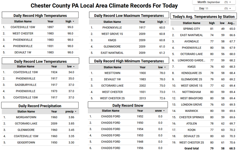
Records (9/11) Highs: EWR: 99 (1983) NYC: 99 (1983) LGA: 96 (1983) JFK: 96 (1983) Lows: EWR: 47 (1932) NYC: 43 (1917) LGA: 51 (1967) JFK: 49 (1967) Historical: 1900: The remnants of the Great Galveston Hurricane were located over central Iowa on this day. Eastern Nebraska, northwest Iowa, and southern Minnesota show four-plus inches of rain from this storm. 1942: A line of thunderstorms raced across Minnesota at 70 mph, destroying 651 barns in a 30 mile wide, 180 mile long path. (Ref. AccWeather Weather History). 1949 - An early snowstorm brought 7.5 inches to Helena MT. In Maine, a storm drenched New Brunswick with 8.05 inches of rain in 24 hours, a state record. (The Weather Channel) 1954: On September 10th and 11th Hurricane Edna crosses Cape Cod and give the Boston area a record 5.64 inches of rain in 24 hours. (Ref. NOAA Boston Weather Events) 1960: Hurricane Donna made landfall during the evening on the North Carolina coast near Wilmington. Winds gusted to 115 mph and the lowest pressure reported with this landfall was 958 mb. Donna would move offshore once again the next morning and regain strength as it stayed just offshore until hitting Long Island shortly afternoon on September 12 with winds of near 100 mph. (Ref. AccWeather Weather History) 1961 - Very large and slow moving Hurricane Carla made landfall near Port Lavaca TX. Carla battered the central Texas coast with wind gusts to 175 mph, and up to 16 inches of rain, and spawned a vicious tornado which swept across Galveston Island killing eight persons. The hurricane claimed 45 lives, and caused 300 million dollars damage. The remnants of Carla produced heavy rain in the Lower Missouri Valley and southern sections of the Upper Great Lakes Region. (David Ludlum) (Storm Data) 1976 - Up to five inches of rain brought walls of water and millions of tons of debris into Bullhead City AZ via washes from elevations above 3000 feet. Flooding caused more than three million dollars damage. Chasms up to forty feet deep were cut across some roads. (The Weather Channel) 1984: (Not to be confused with Diane 1955 Mid Atlantic U.S) Hurricane Diana finally strikes North Carolina coast near Bald Head Island after drifting around the Cape Fear, NC area for two days. Diana made landfall as a category two hurricane, but just the day before, the hurricane had been a category four storm with a central pressure of 28.02 inches of mercury and maximum sustained winds of 135 mph. There were dire predictions of disaster from nervous emergency management officials. Fortunately, Diana stalled and wobbled away from land as it neared the Cape Fear area. Diana was the first significant hurricane to strike the North Carolina coast since Donna of 1960. As the eye passed over Southport, NC residents noted hearing crickets chirping in the calm. Three people died in North Carolina as a result of Diana, but damage was minimal. (Ref. AccWeather Weather History) 1986 - Thunderstorms caused flash flooding and subsequent river flooding in central Lower Michigan. Up to 14 inches of rain fell in a 72 hour period, and flooding caused 400 million dollars damage. (Storm Data) 1987 - Late afternoon and evening thunderstorms produced large hail and damaging winds in Texas, and spawned three tornadoes. Thunderstorm winds gusted to 70 mph at Goodnight TX. (The National Weather Summary) (Storm Data) 1988 - Snow blanketed parts of the Central Rocky Mountain Region and the Central Plateau, with ten inches reported at Mount Evans in Colorado. Smoke from forest fires in the northwestern U.S. reached Pennsylvania and New York State. Hurricane Gilbert, moving westward over the Carribean, was packing winds of 100 mph by the end of the day. (National Weather Summary) (Storm Data) 1989 - Nine cities in the north central U.S. reported record low temperatures for the date, including Havre MT with a reading of 23 degrees. Livingston MT and West Yellowstone MT tied for honors as the cold spot in the nation with morning lows of 17 degrees. Thunderstorms produced hail over the Sierra Nevada Range of California, with two inches reported on the ground near Donner Summit. The hail made roads very slick, resulting in a twenty car accident. (The National Weather Summary) (Storm Data) 1998: An outbreak of 8 tornadoes occurred across southern Louisiana in conjunction with landfalling Tropical Storm Frances that was looping along the upper Texas coast. The only known fatality directly attributable to Frances was in Lafourche Parish, LA, where a man was killed when his trailer home was destroyed by a tornado. Six others were injured. (Ref. Wilson Wx. History) 2001: Hurricane Erin was off the coast of New Jersey and New York on this day. 2002 Tropical Storm Gustav strengthened to a hurricane over the open waters south of New England. This is the latest date for the first hurricane of the season to develop for the Atlantic on record. (Ref. Wilson Wx. History) 2008: Hurricane Ike continued its march towards the upper Texas coast with 100 mph winds and a minimum central pressure of 945 millibars or 27.91 inches of mercury. Hurricane watches and warnings went up along the upper Texas coast into Louisiana. (Ref. Wilson Wx. History) 2017: In the days leading up to the storm, more than 6.5 million Floridians were told to evacuate. In a calamitous northward sweep from the Everglades to the Florida Panhandle, a weakening but still monstrously powerful Hurricane Irma battered a string of cities on the state’s palm-fringed west coast Sunday before advancing toward Georgia and the Carolinas.Irma hits Florida on Sunday night the 10th. Irma data 2017: On Monday, a day after visiting lashing rains, surging tides and terrifying winds on nearly every corner of Florida, Irma unleashed flash flooding in three states and left a sweaty, disruptive legacy: no power for about 7 million people. Confronting a panorama of destruction stretching from coast to coast, with rescue efforts still in progress and a massive cleanup only beginning to gather pace, Florida and federal officials opted for frankness: It might take weeks for electricity to be fully restored. The storm’s direct death toll, mercifully, was not commensurate with Irma’s wrath. Authorities in Georgia on Monday reported three storm-related deaths, without providing details, and one person died in South Carolina. An electrocution was reported in central Florida — a grim hazard in flooding’s aftermath. Irma is being blamed for 34 deaths in the Caribbean before it hit Florida, according to the Associated Press. 2018: Hurricane Florence was a powerful and long-lived Cape Verde hurricane, as well as the wettest tropical cyclone on record in the Carolinas and the ninth-wettest tropical cyclone to affect the contiguous United States. The sixth named storm, third hurricane, and the first major hurricane of the 2018 Atlantic hurricane season, Florence originated from a strong tropical wave that emerged off the west coast of Africa on August 30, 2018. Steady organization resulted in the formation of a tropical depression on the next day near Cape Verde. Progressing along a steady west-northwest trajectory, the system acquired tropical storm strength on September 1, and fluctuated in strength for several days over open ocean. An unexpected bout of rapid intensification ensued on September 4– 5, culminating with Florence becoming a Category 4 major hurricane on the Saffir–Simpson scale with estimated maximum sustained winds of 130 mph. -
Pretty good shot of the inversion that’s so common this time of the year. About 40 this morning but area hills are aoa 50.
-
.45" overnight. Impressive, since next to none was forecast. We hit 75F yesterday at 3:10pm.
- Today
-
2025-2026 ENSO
40/70 Benchmark replied to 40/70 Benchmark's topic in Weather Forecasting and Discussion
After these past seven seasons, I'd sacrafice my right testicle for that season....but normallu, I would describe it is very ordinary and yawnstipating. -
2025-2026 ENSO
40/70 Benchmark replied to 40/70 Benchmark's topic in Weather Forecasting and Discussion
Cold relative to current climo, yes. -
September 2025 OBS-Discussion centered NYC subforum
SACRUS replied to wdrag's topic in New York City Metro
60 / 58 clear. Warmer stretch upper 70s - low 80s perhaps a few of the hotter areas get into the mid 80s today and Sunday. Overall warmer period coming up - cut off ull now into the SE but persistent onshore flow will keep any stronger warmth west of the area. The period Mon - Thu still need be watched for rain with wetter forecasts still appearing, otherwise riding a dry stretch with near 80 and warmer lows vs normal. -
I wonder if actually clears today. As of right now it's pretty socked in and still raining here. Probably another dreary day.


.thumb.JPG.418e8a9a2902ae687ec35ff4bc0e038e.JPG)

