All Activity
- Past hour
-
 While ewr gets to at least 104 Edit i just saw your guesses above
 -
Also, the low of 80F at Eau Claire, Wisconsin was 1F shy of both the June monthly record high minimum and the all-time record high minimum. La Crosse, Wisconsin was 1F shy of the monthly & 2F below the all-time record. Possibility that one or both gets set or tied tonight/tomorrow if the winds stay up enough. Also would need to stand through midnight local time. Not sure if there’s a risk of convection there tomorrow.
-
It was very close on previous outlooks. as mentioned yesterday spc keeps the chances alive but slim untill Monday.
-
hope that HI hits 120!!
-
They knew they had to get it within a run. Scored 2 in the 9th just to make it a 1-run loss, and left the tying run at 3rd base. Poetic.
-
The Park will be tough.
-
lol what is the euro doing in nyc. Congrats metfan and enjoy. concrete jungle!


-
I predict all the June records fall on Tuesday except the Park
-
1 run loss! Devers with the GW RBI!
-
 This is the best shot in a while but I have my doubts. 99 sounds about right.
 -
 we'll see if a cluster comes down or not tomorrow
 -
 Valor joined the community
 -
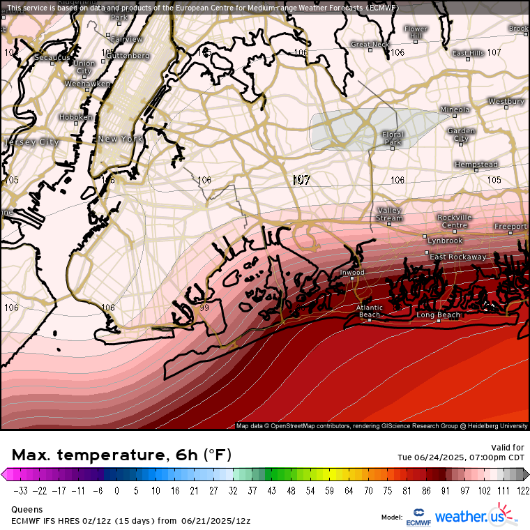
If i had to put out a forecast (for fun) for Tuesday right now I'd go with: EWR 104 SMQ 103 LGA 102 Jfk 102 FRG 102 POU 101 MMU 101 HPN 100 ISP 100 MGJ 99 NYC 99 Somewhere from north central BK to Corona to Hempstead 106 Somewhere between Hempstead and Commack 105
-
88F here. Guess we start the streak tomorrow. .
-
That one event where people got 10 inches in a 5 block wide band? That's @FPizz favorite event.
-
Very cool for late June in PAC NW, currently only 48-50 F at lower elevations of n Idaho and nw Montana, se BC, and snow is reported in mountain passes. A cold drenching rain here, not good for a weekend but great news for forest fire suppression. It is only 45F at my elevation (normal here is 80F).
-
That'll change in a big way
-
Yeah snowmaking snow takes a long time to melt, ha. It’s one of the jumps in the terrain park. Imagine if you had 15 feet of sleet… this is when it would melt lol.
-
 It might do it on Tuesday. I'll be at 104 if that happens which makes me annoyed
 -
Like many of us, I love snow, but days like today, sitting on the patio, drinking a beer, taking a swim, and looking at the perennials in bloom all over the yard, are certainly difficult to beat.
-
This past winter we got only a few more inches than NYC, but we did much better than NYC the winter before that. NYC got only 7.5" for the winter of 23-24, but we got 20 inches here because we had an event in which we were lucky to get under death band.
-
89 here and 89 at MU.
-
Today is stellar. Humidity isn’t bad. 79/57 attm. Enjoy! edit: car thermo registered 90F earlier this afternoon in Northboro while on 290
-
MRGL risk of severe thunderstorms tomorrow. That came out of nowhere.
-
...or a Guardians fan!
-
A sustained period of above normal temperatures is now underway. Excessive heat will overspread the region tomorrow with the mercury soaring into the 90s across the region. Extreme heat is likely Monday, Tuesday, and possibly Wednesday Temperatures will likely top out in the middle and upper 90s in the New York City area and upper 90s to lower 100s in the hot spots in New Jersey. The ECMWF and GFS continue to show potential June monthly record heat for parts of the region. June Monthly Records: Bridgeport: 97°, June 9, 2008 Islip: 96°, June 24, 1966 and June 19, 1994 New York City-Central Park: 101°, June 29, 1934 and June 27, 1966 New York City-JFK Airport: 99°, June 29, 1949, June 26, 1952, June 30, 1964 New York City-LaGuardia Airport: 101°, June 26, 1952 and June 13, 2017 Newark: 103°, June 27, 1952 June 26, 1952 is currently the hottest June day on record in and around the New York City area. Out of the five stations from the above list that were operating in 1952, three reached or exceeded 100° on June 26, 1952 (Central Park: 100°, LaGuardia Airport: 101°, and Newark: 102°). All five reached 95° or above. Two stations also saw 80° or above lows: Central Park: 81° and LaGuardia Airport: 84°. Both the number of 100° highs and 80° lows is the highest on record for June for this five-station area. For June 26, 1952, the five-station average high was 99.4°, the average low was 78.2°, and the mean was 88.4°. The average high and mean are the highest on record for June. The average low is the second highest on record for June. June 21, 2012 was the second hottest day, overall, in this region. Its average high was 96.8°. Its average low was 78.4°. Its mean was 87.6°. That average low was the highest on record for June. The average high and mean were the second highest for June. The ENSO Region 1+2 anomaly was +0.5°C and the Region 3.4 anomaly was 0.0°C for the week centered around June 11. For the past six weeks, the ENSO Region 1+2 anomaly has averaged +0.30°C and the ENSO Region 3.4 anomaly has averaged -0.05°C. Neutral ENSO conditions will likely continue through at least late summer. The SOI was +2.11 yesterday. The preliminary Arctic Oscillation (AO) was +0.206 today. Based on sensitivity analysis applied to the latest guidance, there is an implied 84% probability that New York City will have a warmer than normal June (1991-2020 normal). June will likely finish with a mean temperature near 73.8° (1.8° above normal).

.thumb.jpg.6a4895b2a43f87359e4e7d04a6fa0d14.jpg)