All Activity
- Past hour
-
Mark, is that you????
-

2025 Atlantic Hurricane Season
BarryStantonGBP replied to BarryStantonGBP's topic in Tropical Headquarters
sod off -
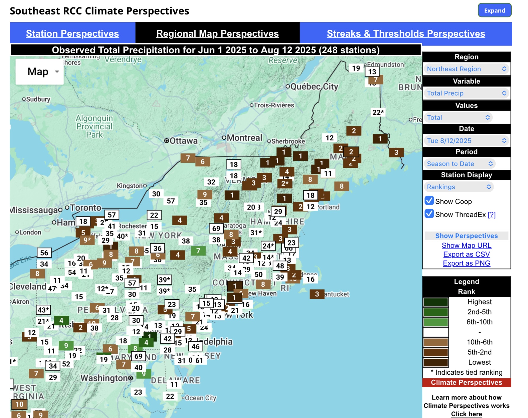
 Received .36" in late afternoon T-Shower. I guess a small slice of pie is better than no slice at all.
 -
Most areas still good.
-
-
Tropical Storm Erin - NOW AT 45 KTS @ 18Z!
BarryStantonGBP replied to BarryStantonGBP's topic in Tropical Headquarters
dorians me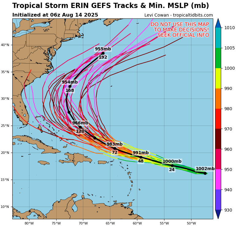
-
Decent rains across eastern sections.
-
None of the cold fronts will take it to the LSV it seems so no reprieve from this humidity for a week at least.
-
I have the 'usual' spots (under the deep tree canopy, lack of sun and trees sucking up all the water and nutrients) that have browned out in last week or so, otherwise an amazing year for grass here!
-
Read an article yesterday, the Farmers Almanacs winter forecast is similar to this guys.
-
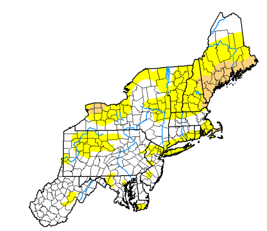
 The Northeast finally got the drought update due to the lack of rainfall this summer.
-
Sounds great. Sometimes trout will find a hole in the river just downstream from where the cool tributaries enter, also the pool below the falls. My only trip there (May 1981) began at Henderson Brook Bridge and ended with a night at the falls, as I had a family trip planned and had stashed my vehicle near Michaud Farm. The rest continued to St. Francis. Parks had asked Seven Islands to check whether the freaky February (CAR had +15 for the month, which also included their 7 mildest days in Feb) that sent the ice bridge downriver had left aspen logs blocking the critical take-out above the falls. All was clear.
-
You mean no hoodies and campfires and grabbing extra blankets and uninstalls and men in suits ? We’re surely see the men in their firefighting suits from the smoke
-
There are signs more ridging tries to build in from the south very late in the month. But we will have a couple of cool downs....which is supposed to happen in Summer. I don't see anything brisk or Fall like.
-
The ACATT thought summer was over and all smoke and coc k from here on out. Silly ACATT
-
Beats my 1.53" for the same period. Had some sprinkles in Farmington last evening, not enough to wet the ground, but not a drop at home.
-
picked up maybe .2" yesterday, keeping things greenish. my lawn has never been this green in august.
-
Well not really...it just helps rip a piece of warmth off from the Midwest. Now if Erin went into the Gulf then maybe it would pump up east coast ridging.
-
My guess is that the PNA is more negative during the winter than last year….2nd year -ENSO
-
That’s what a few were discussing. Erin actually pumps the ridge . Tropics bring heat north and ridge pumping
-
 Records: Highs: EWR: 98 (2005) NYC: 99 (1988) LGA: 98 (2016) JFK: 95 (2016) Lows: EWR: 50 (1941) NYC: 54 (1964) LGA: 59 (1964) JFK: 57 (1964) Historical: 1724: The first recorded tornado in Pennsylvania history occurred on this date. It moved from Chester to Bucks County. (Ref. AccWeather Weather History) 1898 - A deadly, estimated F4 tornado moved southeast from 12 miles northwest of Clear Lake, South Dakota, passing 7 miles north of town and ending about 4 miles west of Gary. Deaths occurred on two farms. One man was killed when the kitchen of his farm house was torn off. Five members of one family were killed along with two labors on another farm as every building was swept away. Buildings suffered massive damage on eight farms. This tornado was one of the earliest, estimated F4 tornadoes on record for South Dakota. 1933: Bakersfield, CA reached 117° to set their all-time record for August. Hanford reached 115° for the second day in a row, tying their all-time August high temperature record. (Ref. Wilson Wx. History) 1936 - Temperatures across much of eastern Kansas soared above 110 degrees. Kansas City MO hit an all-time record high of 113 degrees. It was one of sixteen consecutive days of 100 degree heat for Kansas City. During that summer there were a record 53 days of 100 degree heat, and during the three summer months Kansas City received just 1.12 inches of rain. (The Kansas City Weather Almanac) 1953 - Hurricane Barbara hits North Carolina as a Category 2 hurricane. Damage from the storm was relatively minor, totaling around $1.3 million (1953 USD). Most of it occurred in North Carolina and Virginia from crop damage. The hurricane left several injuries, some traffic accidents, as well as seven fatalities in the eastern United States; at least two were due to electrocution from downed power lines. Offshore Atlantic Canada, a small boat sunk, killing its crew of two. 1964: Strong Canadian high pressure pushing a cold front to the Gulf of Mexico brought unseasonable chilly air east of the Mississippi. The following locations recorded their coldest August temperature: Theilman, MN: 32° (also earliest freezing temperature), Mauston, WI: 33°, and Caledonia, MN: 35°. Other daily record lows included: Duluth, MN: 36°, Rochester, MN: 37°, Madison, WI: 37 °F. (Ref. Many Additional Temperatures Listed On This Link) 1969: Tropical Storm Camille formed near Grand Cayman Island. From the beginning, it was evident that Camille would be an explosive storm. First reports from the reconnaissance plane indicated the storm had already reached tropical storm strength with a central pressure of 999 millibars or 29.50 inches of mercury and sustained winds of 55 mph. By afternoon, the storm would already be classified as a hurricane with a central pressure of 964 millibars or 28.64 inches of mercury. (Ref. AccWeather Weather History) 1974: Bethany Beach, Del.--A young girl was killed by lightning as she stood on the beach. Lehigh Acres, Fla.--Lightning struck four workers as they were preparing to leave a road-construction site. Killed one, injured three. (Ref. Lightning-The Underrated Killer.pdf) 1980: National Airport had a 98° high temperature today the last of 21 consecutive days of 90°F or more. (Ref. Washington Weather Records - KDCA) The temperature reached the century mark for the 53rd time in Dallas, TX, establishing the all-time record for 100 degree plus days in a year. (Ref. AccWeather Weather History) 1987 - Slow moving thunderstorms deluged northern and western suburbs of Chicago IL with torrential rains. O'Hare Airport reported 9.35 inches in 18 hours, easily exceeding the previous 24 hour record of 6.24 inches. Flooding over a five day period resulted in 221 million dollars damage. It was Chicago's worst flash flood event, particularly for northern and western sections of the city. Kennedy Expressway became a footpath for thousands of travelers to O'Hare Airport as roads were closed. The heavy rains swelled the Des Plaines River above flood stage, and many persons had to be rescued from stalled vehicles on flooded roads. (13th- 14th) (The National Weather Summary) (Storm Data) (The Weather Channel) 1988 - Eighteen cities in the northeastern U.S. reported record high temperatures for the date, and the water temperature at Lake Erie reached a record 80 degrees. Portland ME reported a record fourteen straight days of 80 degree weather. Milwaukee WI reported a record 34 days of 90 degree heat for the year. Afternoon and evening thunderstorms resulted in about fifty reports of severe weather in the northeastern U.S. One person was killed at Stockbridge MI when a tornado knocked a tree onto their camper. (The National Weather Summary) (Storm Data) 1989 - Afternoon thunderstorms in Illinois soaked the town of Battendorf with 2.10 inches of rain in thirty minutes. Evening thunderstorms in Montana produced wind gusts to 66 mph at Hobson. (The National Weather Summary) (Storm Data) 1996: Arizona recorded its record wind gust of 114 mph at the Deer Valley Airport on the north side of Phoenix as a severe thunderstorm downburst hit the area. (Ref. Wilson Wx. History) 2002: A 594 decameter area of high pressure off the Carolina coast produced hot south to southwesterly winds ahead of a cold front bringing record heat to parts of the east. The temperature in Boston, MA reached 101°, equaling their August record (8/2/1975). Other daily records included: Syracuse, NY: 101°, Concord, NH: 99°, Hartford, CT: 99°, Allentown, PA: 99°, Philadelphia, PA: 99°, Milton, MA: 98°, Providence, RI: 98°, Rochester, NY: 97°, Harrisburg, PA: 97°, Burlington, VT: 96°, Binghamton, NY: 95° and Erie, PA: 94°. (Ref. Wilson Wx. History) In San Angelo, TX, just after midnight, a descending heat-burst jumped the temperature from 75° to 94° in 30 minutes. The event ended about 90 minutes later when the temperature fell back to 73°. (Ref. Wilson Wx. History) (Ref. WxDoctor) 2004: Hurricane Charley made a second landfall near North Myrtle Beach, South Carolina, on August 14. 2009: (June/28-Sep/6) Iowa temperatures averaged above normal only 10 days in this 71-day period. July’s 68.1 degree average became the coldest July in 137 years of record (old: 68.3 degrees in 1891). The last greater or equal 90 degree noted in IA this year was today – the earliest of record (old: 19th in 1902). (Weather Guide Calendar with Phenomenal Weather Events 2011 Accord Pub. 2010, USA) 2016: August 9-16. Weak low pressure combined with abundant Gulf moisture produced phenomenal rainfall and flooding across central Louisiana, inundating entire neighborhoods and towns, especially around Lafayette and Baton Rouge. Rainfall totals exceeded 20 inches in as little as two days. Thirteen people died and economic costs ranged from $10 to $15 billion.
 -
It's amazing how I went from bitching that every weekend had precipitation to my yard having rock hard soil and dormant grass. This morning the dews just hit me different, like I'm really starting to get sick of them. I don't like them to begin with but I do my best to embrace whatever weather we have but this morning might have been my breaking point LOL
-
 Did your power go out, or internet? .80" yesterday
 -
Looks like it warms uo to the 90s again the weekend after when Erin passes. What a summer.
-
Some of us knew while a select few prayed it wouldn’t be true.