All Activity
- Past hour
-

Spooky Season (October Disco Thread)
DavisStraight replied to Prismshine Productions's topic in New England
Had to deice my windshield this morning, im in Mass this weekend, probably cooler in Maine. -
Didn't we have a massive NF warm pool in Nov/Dec 2000 though? I think that its more the lack of a 50/50 low for some reason that we keep seeing that. We saw it less often last winter however when we had the -NAO because that vortex was there to prevent it from happening.
-
.thumb.png.0012268e273402dcfb9866a0a1e919a3.png)
-
35
-

Spooky Season (October Disco Thread)
CT Valley Snowman replied to Prismshine Productions's topic in New England
Low of 31. Lowest of the season has been 28. -
low of 41F at 6:48. No sign of frost
-
Thats not too surprising given the recent combo of a strong west based -NAO and AK vortex flooding W Canada with mild air. This pattern this month as far as Pac/ATL is about as close to December 2001 or 2012 as you can get.
-
So happy to see the Dodgers get smacked around last night.
-
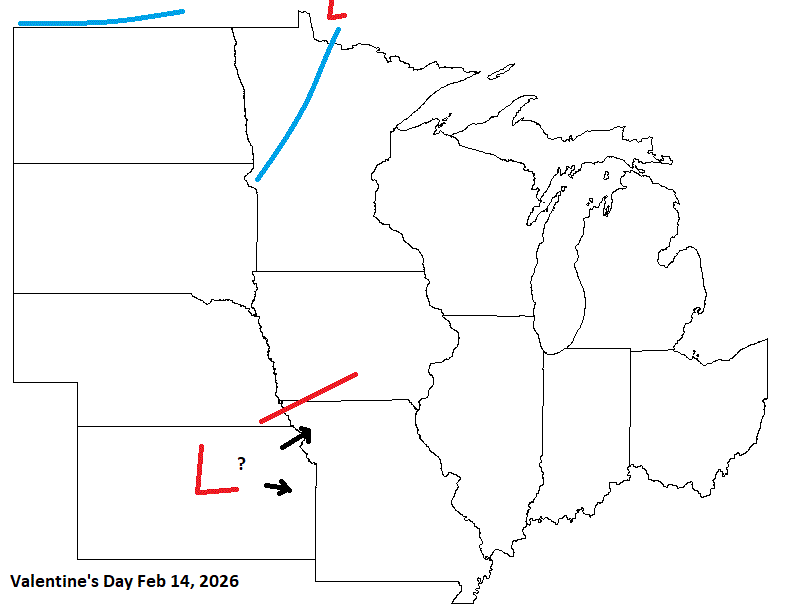
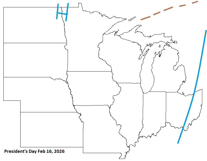
Valentine's n President's day are close this year. Stm potential with colder afterwards is possible.
-
(002).thumb.png.6e3d9d46bca5fe41aab7a74871dd8af8.png)
Central PA Fall Discussions and Obs
ChescoWx replied to ChescoWx's topic in Upstate New York/Pennsylvania
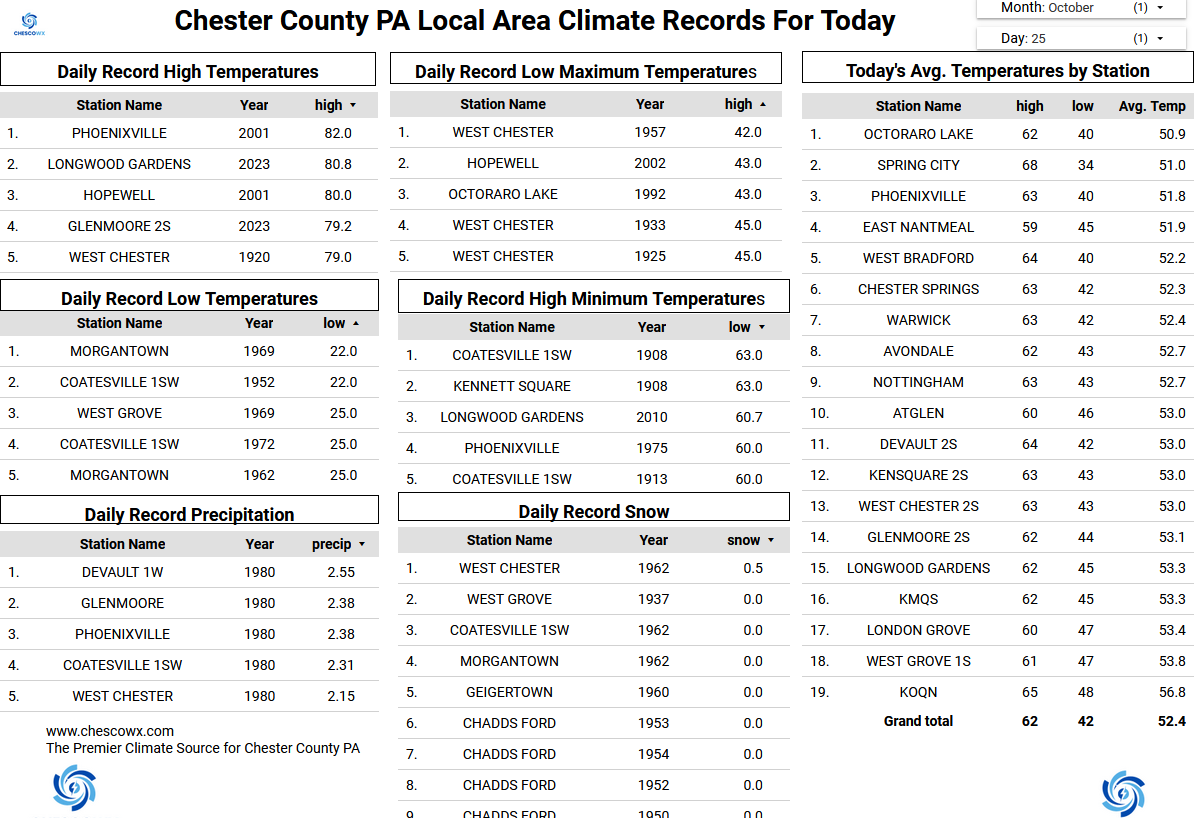
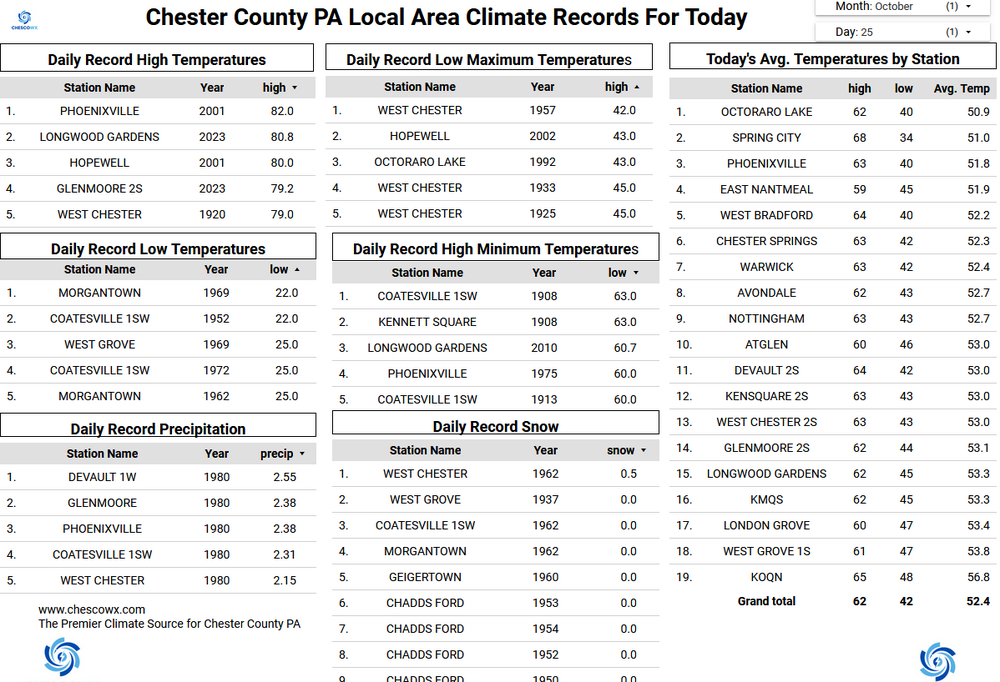
Plenty of lows below freezing across most of the valley locations including Nottingham, Warwick Township, West Bradford, West Chester, Devault with the lowest the 29.1 degree reading at Warwick. At our higher ridge spots like here in East Nantmeal we got no lower than 38.9 degrees this morning. Temperatures during the day have been running 5 to 7 degrees below normal during the last couple of days and this chilly trend looks to continue through at least the next week taking us into the first week of November. We stay dry till midweek when we will turn our attention to a possible coastal storm which may impact the region from Wednesday night into Friday.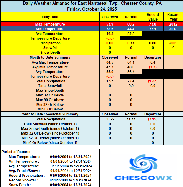
-
E PA/NJ/DE Autumn 2025 Obs/Discussion
ChescoWx replied to PhiEaglesfan712's topic in Philadelphia Region
Plenty of lows below freezing across most of the valley locations including Nottingham, Warwick Township, West Bradford, West Chester, Devault with the lowest the 29.1 degree reading at Warwick. At our higher ridge spots like here in East Nantmeal we got no lower than 38.9 degrees this morning. Temperatures during the day have been running 5 to 7 degrees below normal during the last couple of days and this chilly trend looks to continue through at least the next week taking us into the first week of November. We stay dry till midweek when we will turn our attention to a possible coastal storm which may impact the region from Wednesday night into Friday.
-
GHD timeframe needs to be watch for stm potential.
-
Looks like it will get the upgrade to hurricane at 11
-
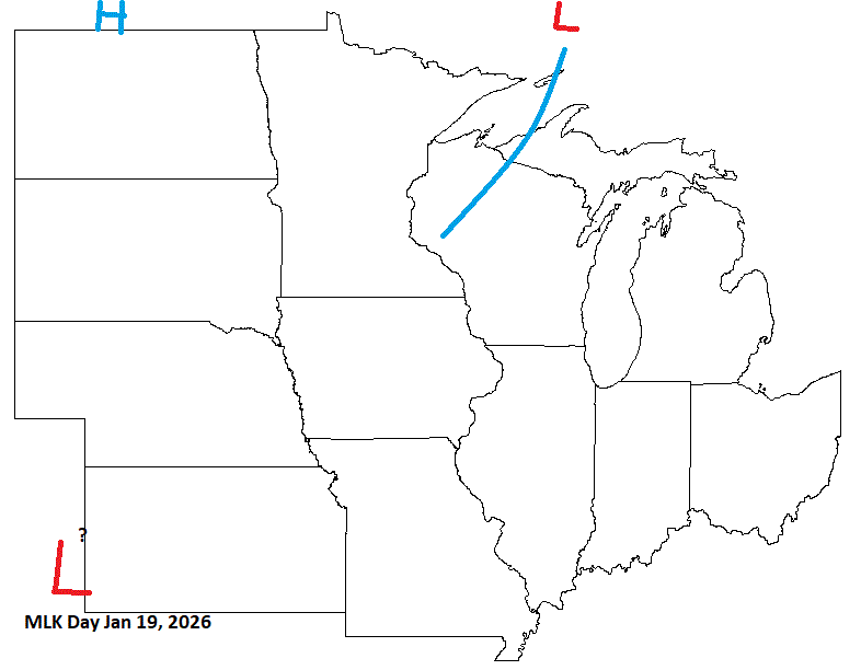
MLK day in mid Jan, I have a weak front up N, with potential energy moving in along that. Something to watch, but mid Jan does look colder, so the pattern may squelch that LP.
-
Absolutely anemic looking snow growth in Canada, especially eastern Canada. Not what you want to see right now.
-
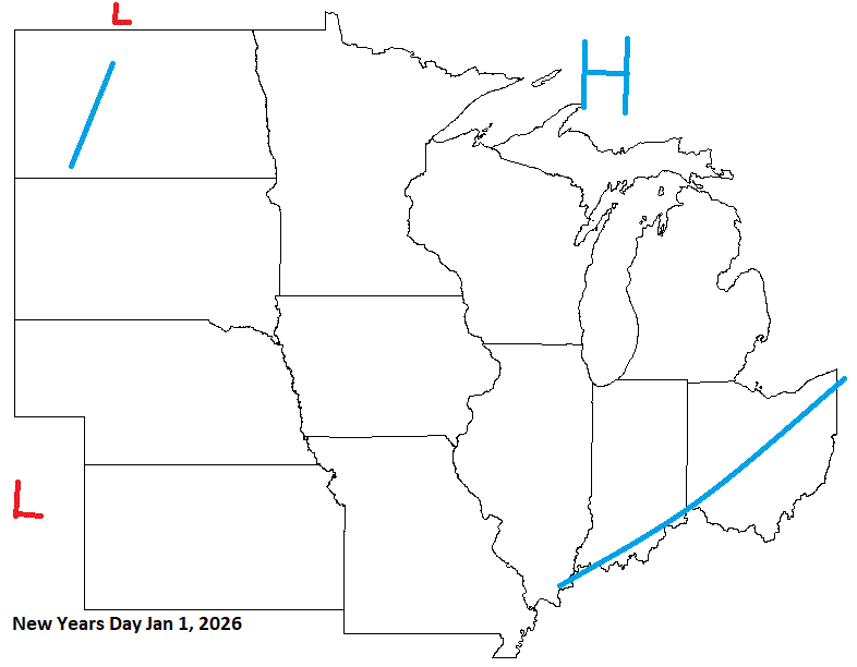
Starting 2026, looks like a CAN front/system moving through. Could be some energy riding up that prior, but by New Years day, I think HP will be over the Lakes.
-
Westhampton hit 30
-
41 for the low again.
-
My wind never died down and only reached 45
-
Coldest morning yet. 38.2
-
34 this morning in Great Falls with moderate frost on the yard.
-

Central PA Fall Discussions and Obs
Mount Joy Snowman replied to ChescoWx's topic in Upstate New York/Pennsylvania
Low of 36. -
Best for Jamaica but worst for SW Haiti with insane amounts of rainfall
-
6z GFS with the best scenario
- Today
-

E PA/NJ/DE Autumn 2025 Obs/Discussion
Hurricane Agnes replied to PhiEaglesfan712's topic in Philadelphia Region
I actually still have my central air on "cool" (with fan constant on to keep the temps even) and it has been keeping it a comfortable 68 in here. I know as soon as I put the heat on, then that will start the humidifier production for me (I have a bunch of them and that means tank fillings and filter changing, etc). I.e., the hot air will send my indoor humidity down below 30% and into the 20% or lower range.


.png.caaa14f1fcdeb3ff44ec2366048a1e6d.png)