All Activity
- Past hour
-

December 2025 regional war/obs/disco thread
SouthCoastMA replied to Torch Tiger's topic in New England
I lived in Acushnet at the time and had 7" or 8". Just south of me along 195 got near a foot. Messenger in Manomet did well too iirc -
Probably the final outcome. I just wanna see flakes, other than the ones here.
-
Yeah. I rag on them but it makes them better. Bulling works
-

Kick-Off '25-'26 Winter Storm Obs
Damage In Tolland replied to 40/70 Benchmark's topic in New England
As close as East Windsor there was a solid 2” as I drove thru there -

December 2025 regional war/obs/disco thread
WinterWolf replied to Torch Tiger's topic in New England
I remember shoveling my girlfriends garage roof(had a very low angle on it) at the very end of January that year(2011), and the roof had 36-38” on it…and the middle was so dense and icy…frieken nuts. Took like 4 hrs to do. We had piles so high that we were jumping off the roof into them. -
updated. i pushed the 1-3 line up a bit to the NW out of Tolland but kept the 1.3" over vernon with a localized area of light blue shading.
-
December 2025 regional war/obs/disco thread
SouthCoastMA replied to Torch Tiger's topic in New England
yeah that was such a blue baller. crazy that 3 weeks later was the SOTC, and my first memory of whiteout conditions. -
2/19/93
-
When riding the fence bet cold rain. If tonight's runs are even warmer yikes.
-

2025-2026 ENSO
donsutherland1 replied to 40/70 Benchmark's topic in Weather Forecasting and Discussion
Yes, there's a different methodology. I use the BOM values when assessing patterns and impacts. -
Overall not a good set of runs at 18z for the I40 corridor. Teetering on the edge, so hopefully things will swing back south overnight
-
December 2025 regional war/obs/disco thread
SouthCoastMA replied to Torch Tiger's topic in New England
I remember that one. flurries/dusting here, and an angry weenie was born -
The coldest air mass so far this season will overspread the region tomorrow night. The cold front could touch off a few scattered snow flurries or snow showers. The temperature will tumble into the lower 20s by Friday morning in New York City. Many areas outside the City will see lows in the teens. It now appears that the weekend will be cool but dry. A colder than normal pattern is in place. A prolonged stretch of below normal temperatures will likely continue into or through the second week of December. December 1-10 will be a solidly colder than normal period. The potential exists for the coldest first 10 days of December since at least 2007 (33.4°, 5th coldest December 1-10 since 2000). The five coldest December 1-10 periods since 2000 were: 1. 30.6°, 2002 2. 32.2°, 2003 3. 32.4°, 2000 4. 33.1°, 2005 5. 33.4°, 2007 All 5 of these cases had measurable snowfall in Central Park. The ENSO Region 1+2 anomaly was -0.1°C and the Region 3.4 anomaly was -0.6°C for the week centered around November 26. For the past six weeks, the ENSO Region 1+2 anomaly has averaged -0.18°C and the ENSO Region 3.4 anomaly has averaged -0.67°C. La Niña conditions will likely continue through at least mid-winter. The SOI was -28.49 today. The preliminary Arctic Oscillation (AO) was -0.144 today.
-
Kick-Off '25-'26 Winter Storm Obs
Damage In Tolland replied to 40/70 Benchmark's topic in New England
Yeah 1/4 all of it last night -
Not yet but if I had to put the odds on it I would say 80% cold rain here in greater McDowell.
-
Im not ready to throw in the towel yet with so many variables on the table… .
-
 Suffolk got a T…we got about 30 min of snow
 -
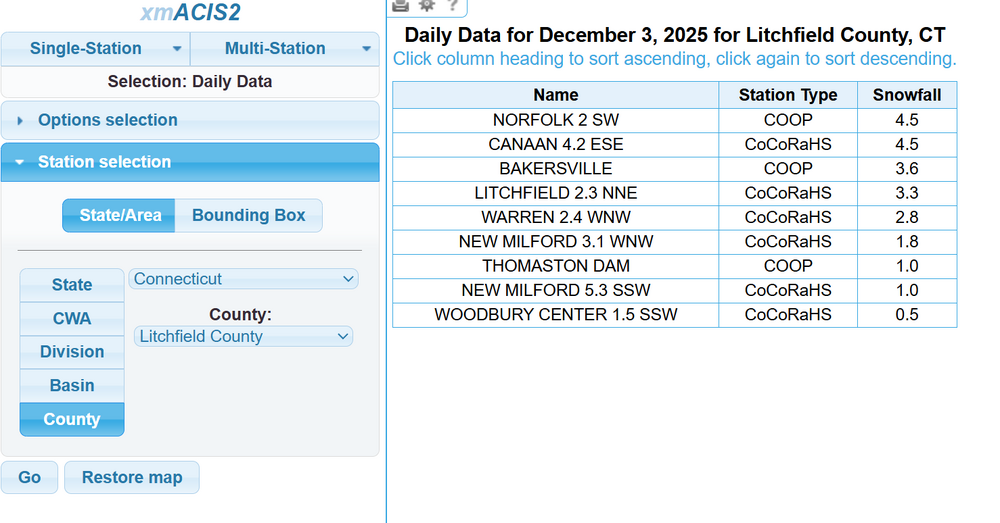
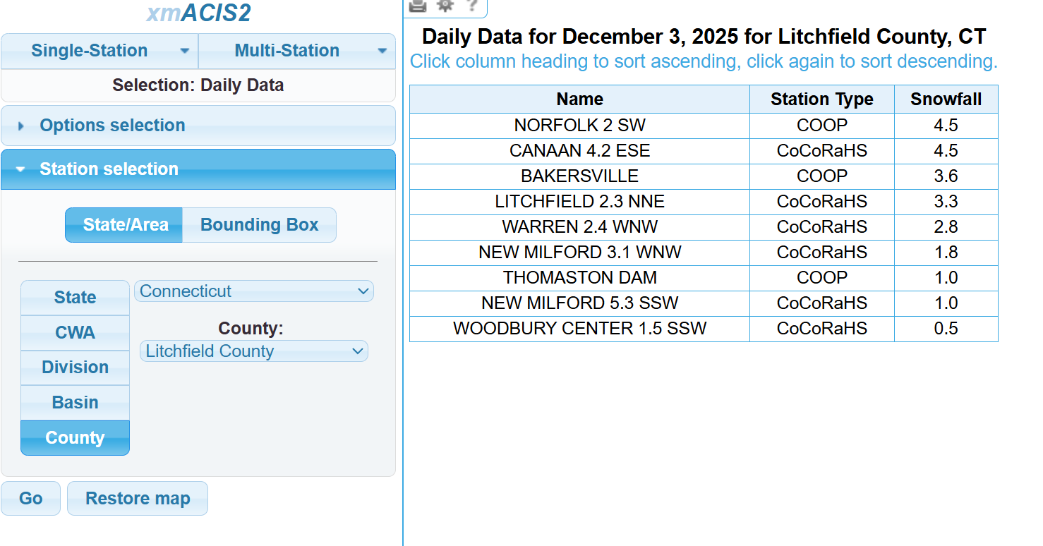
I'm closer to the 6.5 on that map or NE of the 7.4 .. I'm guessing that's the Baldwinville report which has a bit lower of a elevation.. some other towns around here beat me so no jack ...Worcester County... 2 SSE Ashburnham 8.9 in 0714 AM 12/03 Public Sterling 4.3 NW 8.5 in 0700 AM 12/03 COCORAHS 1 WNW Sterling 8.5 in 0545 AM 12/03 Trained Spotter 1 WSW Westminster 8.3 in 0345 AM 12/03 Trained Spotter 1 E Fitchburg 7.7 in 0710 AM 12/03 Trained Spotter 3 SSE Gardner 7.5 in 0841 PM 12/02 Trained Spotter Templeton 7.4 in 0120 AM 12/03 Trained Spotter Ashburnham 7.3 in 0700 AM 12/03 COOP 1 NNE Baldwinville 6.5 in 0718 AM 12/03 Amateur Radio
-
Feb 93 was a crazy one on the Cape. 2’ in Chatham with 4”/hr. That was your classic NORLUN. I remember watching Bob Copeland and just getting so angry lol.
-
thats not good bug it was terrible at 12z to begin with
-
all good, should i use 0.3 (0.25 rounded) for your total? and where abouts are you in tolland (miles from center) i used 8 (Greenfield COOP) and 6.5 respectively for those. Hard to fit everything in but they were in the >6" range
-
Seems we have seen this movie many times over the last few years with these weak systems. They seem to trend a bit north as we get closer. There isn’t a ton of upside, it’s not gonna magically juice up, best case is areas in the skunk zone get a coating and that 1-2 inch expands a bit. Will be interesting to see if this scenario plays out again this time. Maybe the models have been having trouble resolving the cold and dry air to the north at range, maybe a data sampling thing…maybe aliens.
-
Kick-Off '25-'26 Winter Storm Obs
Damage In Tolland replied to 40/70 Benchmark's topic in New England
Could be but I went thru Vernon yesterday and there wasn’t close to an inch . Again no biggie -
Thanks, Don. Just to make sure there’s no confusion of the viewers, these ERA-5 values do not match the BoM RMM values. So, they aren’t substitutes for each other as they’re not the same way of tracking the MJO. Examples: - The end of the ERA-5 is on 8/31/2023. Here are the values on 8/25-31/2023 from both the ERA-5 and the BoM RMM: 8/25: ERA-5 is in ph 7 at 1.1 amp 8/25: BoM is in ph 8 at 0.84 amp 8/26: ERA-5 is in ph 7 at 1.06 amp 8/26: BoM is in ph 8 at 0.85 amp 8/27: ERA-5 is in ph 7 at 0.97 amp 8/27: BoM is in ph 1 at 0.64 amp 8/28: ERA-5 is in ph 7 at 0.83 amp 8/28: BoM is in ph 2 at 0.46 amp 8/29: ERA-5 is in ph 7 at 0.66 amp 8/29: BoM is in ph 2 at 0.27 amp 8/30: ERA-5 is in ph 7 at 0.46 amp 8/30: BoM is in ph 3 at 0.28 amp 8/31: ERA-5 is in ph 7 at 0.24 amp 8/31: BoM is in ph 3 at 0.26 amp ERA-5 MJO 1/2/1940-8/31/2023 https://www.psl.noaa.gov/mjo/mjoindex/omi.era5.1x.webpage.4023.txt BoM RMM MJO 6/1/1974-present https://www.bom.gov.au/clim_data/IDCKGEM000/rmm.74toRealtime.txt
-
1.3" is for Vernon, there were no reports i saw from Tolland. The 1.3" vernon report was to your WSW and there was another report from Bolton of 1" south of that. There was a very sharp cut off as you can see from Somers 1.9" to Staffordville 0.3" There was several hundred reports to go through i can't exactly verify every single one and based on the surrounding reports it looked reasonable gotcha thats the only report i saw from Thomaston. Thomaston Dam COOP