All Activity
- Past hour
-
Records: Highs: EWR: 97 (2021) NYC: 98 (1925) LGA: 95 (2021) JFK: 90 (1968) Lows: EWR: 43 (1945) NYC: 47 (1945) LGA: 49 (1945) JFK: 51 (2000) Historical:: 1816 - The temperature reached 92 degrees at Salem MA during an early heat wave, but then plunged 49 degrees in 24 hours to commence the famous year without a summer . (David Ludlum) 1816: The temperature reached 92 degrees at Salem, Massachusetts during an early heat wave, but then plunged 49 degrees in 24 hours to commence the famous "year without a summer." Snow fell near Quebec City, Quebec Canada from the 6th through the 10th and accumulated up to a foot with "drifts reaching the axle trees of carriages." 1869: Snail shells fell from the sky at Chester, PA during a rain shower. (Ref. Wilson Wx. History) 1894 - One of the greatest floods in U.S. history occurred as the Williamette River overflowed to inundate half of the business district of Portland OR. (David Ludlum) 1894: One of the greatest floods in U.S. history occurred as the Willamette River overflowed to inundate half of the business district of Portland, Oregon. The river crested at 33.5 feet, the worst flood ever recorded in the city. 1906: A tornado causing F4 damage moved east-northeast from 3 miles southwest of Caledonia, MN, crossing the Mississippi River about 12 miles south of La Crosse, WI. A mother and two children were killed as their farm near Freeburg, MN was leveled. One child was carried about half a mile. 15 people were injured in rural Minnesota homes. An F3 tornado moved east-northeast out of Winneshiek County, Iowa destroying a large brick home southeast of Newhouse, MN just inside the Minnesota border. Clothes from the home were found over three miles away. One boy was severely injured, and may have died later. He had been closing windows on the second floor when the tornado struck. Also, on this date, an F2 tornado touched down just southeast of Sparta, WI and it moved north-northeast to near the Jackson County, Wisconsin border. The worse damage was east of Angelo, where "trees and barns were torn to shreds". (Ref. Wilson Wx. History) 1907: A tornado causing F4 damage killed 5 people and injured 20 others in Washington County in Illinois. (Ref. Wilson Wx. History) 1925: Boston, MA recorded its highest temperature of 100 °F and its warmest low temperature, 80 °F for the month of June. (Ref. NOAA Boston Weather Events) 1937: Dome Lake, MT in the Bighorn Mountains, was buried under 32 inches of snow. (Ref. Wilson Wx. History) 1944 D-Day: What did the D stand for ?? Answer The designated Day (To keep the real date hidden) Weather played a critical role in the decision of when to invade Normandy Beach in northern France. Each element of the allied forces needed a certain type of phenomena that best suited their needs. The navy and army needed high tides so the invading soldiers would not get hung up in the water. Further inland, the paratroopers needed a moonless sky so they would not be seen. Dates in May and very early June were set which met those criteria, but were called off because of very bad weather. On the early morning on this date, the weather was once again atrocious with high winds and rain. It was either invade now, or wait until late June when all the elements of moon and tide were together again. But this would risk the Germans fortifying their positions at Normandy. So the decision was made to attack on June 6th. The waves were high, and many soldiers got sea- sick, but the mission was a success. As a matter of fact, the weather was even worse in late June for the alternate landing than it was on this date. (Ref. Wilson Wx. History) 1953: On June 4th, the center of Tropical Storm Alice passed about 60 miles west of Dry Tortugas and moved very near parallel to west coast of Florida and passed inland a short distance west of Panama City, about noon on this date. Winds remained below hurricane force during entire history of this storm and highest winds experienced on land were 40 to 45 mph. The storm produced beneficial rainfall. (Ref. Wilson Wx. History) 1963: Three lightning deaths occurred during the afternoon across Florida: At Tampa: Lightning killed a small child in a bathtub and lightning killed a person repairing a roof. At Lake Seminole: Lightning killed a fisherman standing on the lake bank. (Ref. Wilson Wx. History) 1975 - A tornado, reportedly spinning backwards (spinning clockwise), was sighted near Alva, OK. (The Weather Channel) 1977 - Severe thunderstorms with large hail and winds to 100 mph caused one million dollars damage around Norfolk, VA. A forty-two foot fishing boat capsized near the Chesapeake Bay Bridge Tunnel drowning 13 of the 27 persons on board. (The Weather Channel) 1978: Severe thunderstorms developed along a strong cold front during the afternoon and continued into the following morning across parts of South Dakota. The storms stretched from Meade County in the west central to Roberts County in the northeast. Numerous reports of golf ball size were reported, damaging crops across the north. Thunderstorm winds also gusted to 70 mph in many areas. Total crop and property damage from the night's storms was estimated to be near $7 million dollars. (Ref. Wilson Wx. History) 1984: An unseasonable storm buried portions of the Colorado Rockies between the 5th and the 8th with as much as two feet of snow with 18 inches in 24 hours ending on the 7th at Climax. Their storm total was 22.3 inches. June storm records set included 3 inches at Eagle, 15.5 inches at Aspen, and 16 inches at Breckenridge. (Ref. Wilson Wx. History) 1986: The Great Salt Lake in Utah reached its historic high water level with the surface level at 4,211.85 feet, exceeding the previous record of 4,211.60 feet by 3 inches. The previous record was set in June of 1873 before the building of any causeways or dikes.(Ref. Wilson Wx. History) 1987 - Thunderstorms in southern California produced one inch hail at Mount Pinos, and marble size hail at Palmdale. Thunderstorms in southeastern Arizona produced heavy rain leaving some washes under four feet of water. Six cities in the north central U.S. reported record high temperatures for the date as readings soared into the upper 90s. (The National Weather Summary) (Storm Data) 1988 - Seventeen cities in the north central U.S. reported record high temperatures for the date, including Williston ND with a reading of 104 degrees. Thunderstorms in Florida produced wind gusts to 65 mph which damaged two mobile homes northwest of Melbourne injuring six people. (The National Weather Summary) 1989 - Thunderstorms developing during the late morning hours produced severe weather through the afternoon and night. Thunderstorms spawned 13 tornadoes, and there were 154 reports of large hail and damaging winds. A strong (F-3) tornado injured six persons at Lorenzo, TX, and thunderstorm winds gusting to 100 mph killed one person at Glasscock City, TX. Softball size hail was reported at Lipscomb and Glen Cove TX. (Storm Data) (The National Weather Summary) 1994: In west central Kansas, hail five inches in diameter knocked holes in roofs and damaged windshields and farm machinery 7 miles south of Tribune. (Ref. Wilson Wx. History) 2001: Feeder bands from Tropical Storm Allison dumped heavy rains over Southeast Louisiana. By the 8th, many locations from Baton Rouge south to Thibodeaux were deluged with 10 to 18 inches of rain, which produced tremendous flooding. Another round of heavy rains erupted on the 10th and 11th as Allison's remnants moved directly over the same area. By the end of the second round, up to 30 inches had fallen in the area around Thibodeaux, LA. (Ref. Wilson Wx. History) 2008: Strong thunderstorms pushed across southeast Illinois during the early morning, producing widespread rainfall of 3 to 7 inches. The highest total of 9.10 inches occurred south of Martinsville, in Clark County. Nearly 100 homes in the county were damaged from the resulting flash flooding, and every county road as well as portions of I-70 was closed due to high water. (Ref. Wilson Wx. History) 2010: Tornadoes and thunderstorms tore through the Midwest USA, killing at least seven people in Ohio and triggering the automatic shutdown of a nuclear power plant in Michigan. In northwest Ohio, seven people were confirmed dead in mostly rural Lake Township south of Toledo. Severe storms caused the automatic shutdown of the Fermi 2 nuclear power plant on the shore of Lake Erie in southeast Michigan after a key area of the plant lost its power feed. Tornadoes also touched down in several locations in central Illinois around Peoria, with reports of dozens of injuries and damaged buildings.(Ref. Wilson Wx. History)
-
Strangely foggy down at the swamp this morning. South River heavy fog also, but lifting. Clear otherwise. DP 66
-
The trick is to not even look at model guidance, maybe some twitter posts, and “guide” the weather to the outcome you want.
-
hammered?
-
Dressed for January, yes.
-
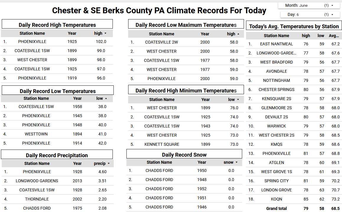
Today will be our last day with high temperatures near 80 degrees for about the 5 days. That is pretty close to the normal high for next week across the area. The good news is there is no sign of any 90-degree temperatures across Chester and SE Berks Counties till late June. Rain chances increase tomorrow and through the weekend but not a washout. The NWS has forecast of rain to be between a 0.25" to 0.50" by Monday morning. Generally showery weather looks likely to continue for Monday and Tuesday before we finally clear up and warm up to near 80 degrees again by mid-week.

-

E PA/NJ/DE Summer 2025 Obs/Discussion
ChescoWx replied to Hurricane Agnes's topic in Philadelphia Region
Today will be our last day with high temperatures near 80 degrees for about the 5 days. That is pretty close to the normal high for next week across the area. The good news is there is no sign of any 90-degree temperatures across Chester and SE Berks Counties till late June. Rain chances increase tomorrow and through the weekend but not a washout. The NWS has forecast of rain to be between a 0.25" to 0.50" by Monday morning. Generally showery weather looks likely to continue for Monday and Tuesday before we finally clear up and warm up to near 80 degrees again by mid-week.
-
That’s why I was originally thinking remaining along CT/MA border. Unfortunately, this may be the “best”/only opportunity of vacation so have to roll with it. Maybe Tuesday can offer something or next Saturday but too far out.
-
74 / 65 clouds to the lest , clouds to the right stuck in the middle with some sun. Warm / humid clouds are lined up to arrive later this afternoon capping most in the mid - upper 80s, but with enough sun could see a stray 90 or two (readings). Some isolated / scattered shower - storms later. Moving into another 72 - 96 hours of mainly grey / cloudy with chance of showers /storms each of the next 4 days Fri - Mon / Tue AM. Front / boundary slow to clear and hang by the area and coast eventually through Tuesday. Clear out Wed and warm up to / with the next shot at some 1-2 days heat Thu (6/12) / Fri (6/13) befor next front come through timing - weekend 6/14. Beyond there overall warm heat is focussed west with heights and more sustained heat heading east by the week of the 22.
-
I am in a slight.... nice
-
It was late May. I’ll see if I can find the storm reports.
-
I didn't think it was possible... but reading these forms, it might be harder to decipher whether its hot/cold in the summer than cold/snowy or dry in the winter . Seems like people make the models support there belief regardless of what it shows.
-
I was just checking Facebook to see if you knew lol
-
We had a setup in 2004 like this. All the action was on cold side of front but big time storms. Had two days of nickels and larger.
-
The constant jet extensions led to wild fluctuations in the WPO,EPO, PNA, AO, and maybe even the NAO. This would have been a great winter before the big warming jump in 15-16. We need a significant relaxation of this jet in coming winters for at least a small rebound off the record low snowfall and cuttter regime of the last 7 years.
-
If I had to chase I'd probably take my chances with the surface based instability in the valley S of HFD and just hope something pops. Could bust completely but higher upside IMO. Often further north has better dynamics but I just don't see them today.
-
yeah, I'm high confidence after eval that this was a wet microburst. Specific rad pulse took place as sat showed a circumvella over shooting anvil exploding radially, and then within moments we had timbre cracked wind/rain/hail for 5 minutes of hell. As Chris Farley would say .... " It was AWWesome"
-
yeah same here
-
It sucks shear blows.
-
Here’s the global surface air temp. graph going through 5/31/25:

-
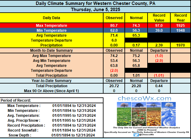
89 degrees for the high yesterday. .05” of rain from the showers that come through. Most stayed north of us. My AC is set at 68 degrees.
-
I can't get excited at all for setups with no shear and New England style high instability You want to give me >4k mucape pulsers maybe I'll raise an eyebrow, but otherwise meh
-
Maybe we can get close enough to the heat some for NW flow.
-
Meh. Heat is done. Even that period after next weekend looks meh.
-
Probably have to head to southwest NH today.