All Activity
- Past hour
-

October Comes Early: Late September Multi-Hazard Hybrid Storm
Ginx snewx replied to WxWatcher007's topic in New England
Fixed yes API -

October Comes Early: Late September Multi-Hazard Hybrid Storm
DirtySnowDen replied to WxWatcher007's topic in New England
Remember it’s meteorology and not modelogy, that low pressure is already lapping up the cold air as it sits over warm-ish water. It’s gonna force the high to weaken and split, funneling the same low pressure at the same time. -
 Bookmarked, site is beautiful Sent from my SM-S176V using Tapatalk
 -
So refreshing outside. Sucks we will be back near 85+ the mid to end next week. Ugh. Got down to 50* here last night. Wish we can bottle this up for the next month or so.
-

Strong Nor'Easter/Hybrid Storm Late September 2026
Neblizzard replied to Rjay's topic in New York City Metro
12z GFS is a soaker for most of the area . 2-3 inches of rain as the storm drives right into NJ -

October Comes Early: Late September Multi-Hazard Hybrid Storm
HIPPYVALLEY replied to WxWatcher007's topic in New England
I’m getting the feeling New Jersey through Southern Connecticut takes the brunt of this. -
October Comes Early: Late September Multi-Hazard Hybrid Storm
HIPPYVALLEY replied to WxWatcher007's topic in New England
yeah, probably be able to pull super cooled columns of air out of the stratosphere and flip some over to snow. -
October Comes Early: Late September Multi-Hazard Hybrid Storm
DirtySnowDen replied to WxWatcher007's topic in New England
The fact, if correct, initialization is lower than expected, it’s punching through that high. -
Whomp whomp
-

October Comes Early: Late September Multi-Hazard Hybrid Storm
weatherwiz replied to WxWatcher007's topic in New England
GFS doesn't seem as inverted either, especially inland. In fact, even developing a couple hundred J of MUCAPE -

October Comes Early: Late September Multi-Hazard Hybrid Storm
CoastalWx replied to WxWatcher007's topic in New England
Better LLJ too. -
October Comes Early: Late September Multi-Hazard Hybrid Storm
CoastalWx replied to WxWatcher007's topic in New England
Yep, there’s gonna be periods where it might be dry and not much going on, and then absolute downpours at other times. -

Strong Nor'Easter/Hybrid Storm Late September 2026
Big Jims Videos replied to Rjay's topic in New York City Metro
I can tell you no one is calling this Sandy in the respected media. I don't know what the clickbate Facebook-ologists are saying but this idea of the media hyping this as a Sandy is simply not true. (You're not doing that but I'm seeing many angry posts from people telling us stop hyping) -

October Comes Early: Late September Multi-Hazard Hybrid Storm
WxWatcher007 replied to WxWatcher007's topic in New England
I think the only caveat there is if we get real banding. I can see periods where it pours under those and people see localized issues. -

October Comes Early: Late September Multi-Hazard Hybrid Storm
ineedsnow replied to WxWatcher007's topic in New England
By hr42 actually bumps north -
October Comes Early: Late September Multi-Hazard Hybrid Storm
ineedsnow replied to WxWatcher007's topic in New England
GFS north of 6z and close to 0z -
October Comes Early: Late September Multi-Hazard Hybrid Storm
DirtySnowDen replied to WxWatcher007's topic in New England
Scooters “banana high” is literally getting broken, evenly. -

Strong Nor'Easter/Hybrid Storm Late September 2026
bluewave replied to Rjay's topic in New York City Metro
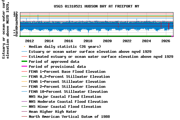
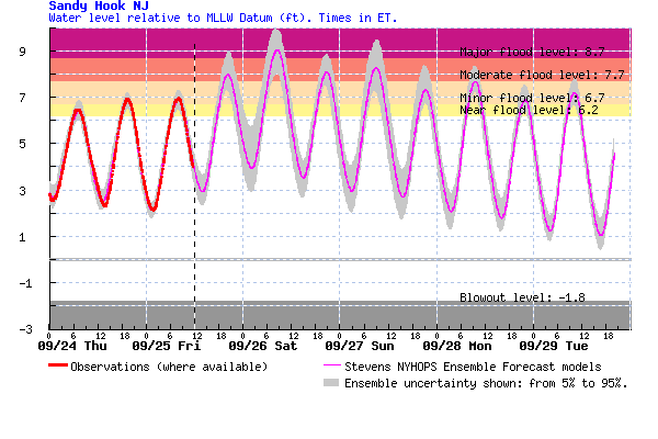
Yeah, Sandy Hook could reach the 9ft level or a bit higher which would only require a 3.5 foot surge on top of the 5.5 astronomical level with the full moon tomorrow morning. A 4 foot surge coinciding with the morning height tide would get to the 9.5 foot level. The back bays of Long Island could see an even higher surge relative to their locations. The models have a tide level in Freeport forecast close to 8 foot mark. That would approach the Hurricane Irene tide level.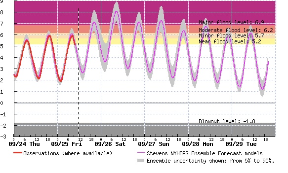
-
Brewings and Eats didn’t have it yesterday, so I’m assuming Ches and Maine doesn’t either. They don’t open until evening, so it may be off to Milton!
-
October Comes Early: Late September Multi-Hazard Hybrid Storm
DirtySnowDen replied to WxWatcher007's topic in New England
The is going to be bad, the fact the broad and oddly cold high pressure is splitting into a two engine system as the tropical low pressure comes north and hits a wall it spilts evenly, not allowing it to leave in either direction so it’s lost and there is a Full Moon this weekend. -

October Comes Early: Late September Multi-Hazard Hybrid Storm
MegaMike replied to WxWatcher007's topic in New England
You developed it? Nice! I like your visuals/displays. Did you get all forecast data from an API? For wind speed, I see: The mean wind speed in the screen cap == 17.8 mph, but shouldn't it be mean(23.4+20.2+23.5+27.4+20.4+21.7+23.5) = 22.9 mph? Nothing is below 20.2 mph for wind speed.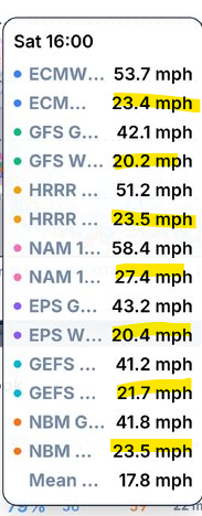
-

E PA/NJ/DE Autumn 2026 Obs/Discussion
Lady Di replied to PhiEaglesfan712's topic in Philadelphia Region
Picked the wrong weekend to go down to the bay and close the cottage for the season. Ugh. Forecast changed daily and who would have thunk another left hook? I have most things already inside so will go down tonight and get the rest in before the rain. Daughter will be there so we'll just hangout. Only see a small craft advisory posted, but will see what the winds do there. Edited to add: This is the Elk River across from Turkey Point.
-

October Comes Early: Late September Multi-Hazard Hybrid Storm
Brian5671 replied to WxWatcher007's topic in New England
Winds really picking up here gusting into the 30-35 mph range -

October Comes Early: Late September Multi-Hazard Hybrid Storm
kdxken replied to WxWatcher007's topic in New England
Birds are going crazy in the woods. Apparently sharp drops in barometric pressure send them into a feeding frenzy. Most quick drops usually occur in the winter so i have never noticed. -
Surprised they don't have it at the brewpub or the restaurant. If you go the brewery, get an aged bottle if they have it. Get a 120 too. Last time I was there they were 16 bucks. I went during Covid and bought a 2009 WWS and a 2013 120 min IPA.