All Activity
- Past hour
-

February 2026 Medium/ Long Range Discussion: 150K Salary Needed to Post
GaWx replied to Weather Will's topic in Mid Atlantic
You’re welcome. It’s not just that though. As my example and examples that can be found on just about every run show, it literally has very heavy snow with these Gulf blobs when temperatures aren’t just a few degrees above 32 but rather as warm as ~40 degrees above 32! How can a major company let these Euro AIFS snow maps with this obvious major issue that’s as plain as day continue to be released before getting them fixed? -

Texas 2026 Discussion/Observations
Stx_Thunder replied to Stx_Thunder's topic in Central/Western States
Looks a little interesting this evening with the ongoing severe risk and some more discrete clusters ongoing in S-SETX coastal region on the southern extent of the frontal convective line moving through ETX. Stronger support aloft is digging a bit further south in the state than usual with the incoming SS trough. And this may be an indication that the ENSO has finally started its transition away from LN and hopefully toward a warm/EN phase in the coming months. Probably the bigger story today is rainfall amounts especially in NTX over 2" just in the past 24 hours with some flash flood alerts. Especially considering we're currently in the driest month of the year. Very needed since over 90% of the entire state was already in some kind of ongoing drought status looking at U.S. drought monitor data on February 3rd. -
So serious analysis. It’s close. Boundary temps are the only issue. Places NW of 95 in MD are at 34-35 during the height of the storm with .25-.35 qpf across guidance now. If the storm were to amp say 2mb deeper and that became .5 qpf it would be enough to flip to a 1-3” snow. 4mb and .75 qpf and its a 3-5” wet snow! It’s that close. The track is perfect. But our temps are torched at the surface so we need a stronger storm to max dynamic cooling 2 degrees more than current progs. How likely is this? 10-20%. Getting that amount of error isn’t unlikely but unfortunately it’s more likely to be in the other direction. Models have a slight over amp bias and a +qpf bias. So we’re rooting for a bust that goes the opposite way or typical errors! Not impossible. There have been examples. It’s not totally dead. But it’s on life support and we need some world class surgeon to swoop in and perform a miracle surgery.
- Yesterday
-
 There’s no question it’s harder to snow now than it was 50 years ago as we lose 1 or 2 marginal events per year. OTOH suppose we hit on the storm last February and 2 weeks ago? Both missed due to phasing issues not warming issues. We’ve been extremely unlucky on big storm chances the past few years.
 -
Lets see the runs tonight
-
Just because we don’t agree on how to interpret temperatures and sky cover doesn’t mean we aren’t friends. Go UCONN!
-
So this isn't a weaker version of a system progged over a week ago?
-
12/09/05 is my number 1 weather experience and I have been on a successful tornado chase. Being 15 walking home from school in the middle of the road because I couldn’t see 20’ in front with non-stop CGs will be hard to top. Perhaps a hurricane Michael style eye or a Manchester, SD type tornado.
-
 Thanks. Ya we’ve noted this too. I tried to fire out wha it was but it’s as if they set the freezing temp to 35 instead of 32 or something. It defaults anything close to snow.
 -
Massive KU, just get it to phase 6 hours earlier , signal has been there but we have a problem getting these signals to hold . Seems like the AI models love to hold a signal in the 8-12 day range then lose it and never bring it back. This one is within day 8..
-
Depends what you’re expecting. If you’re expecting plowable or more, it’ll likely be a bust. If you’re expecting brush off your car, you’ll probably be happy.
-
No idea lol. At some point I will be looking to upgrade. Getting close to 120k miles.
-
OMG what?!?! That’s insanity.
-
Calling a bust before a storm starts Weenie
-
Trying to get it back lol. Models are crazy
-
Nice Euro skynet run at 18z…can we lock in next Sunday?
-

Presidents' day Snow potential
WeatherGeek2025 replied to WeatherGeek2025's topic in New York City Metro
you said busy last time. and it came back lol -
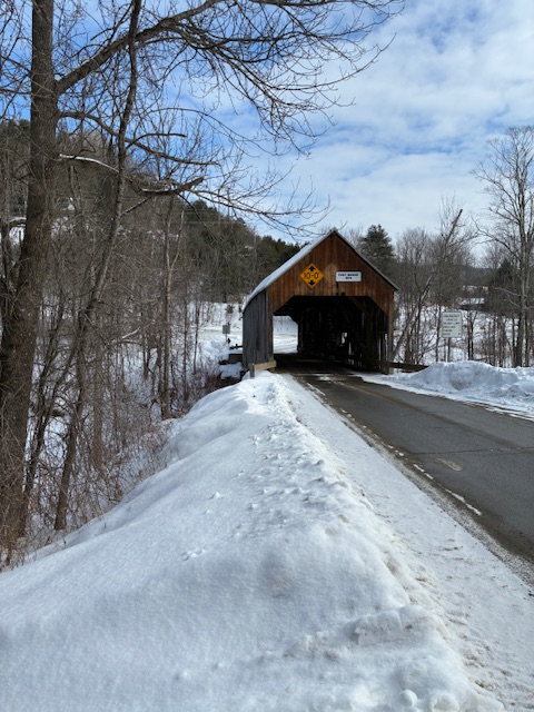
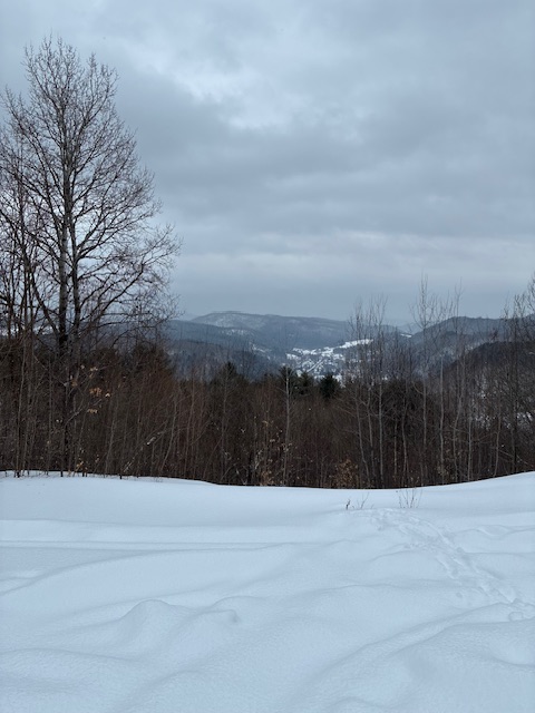
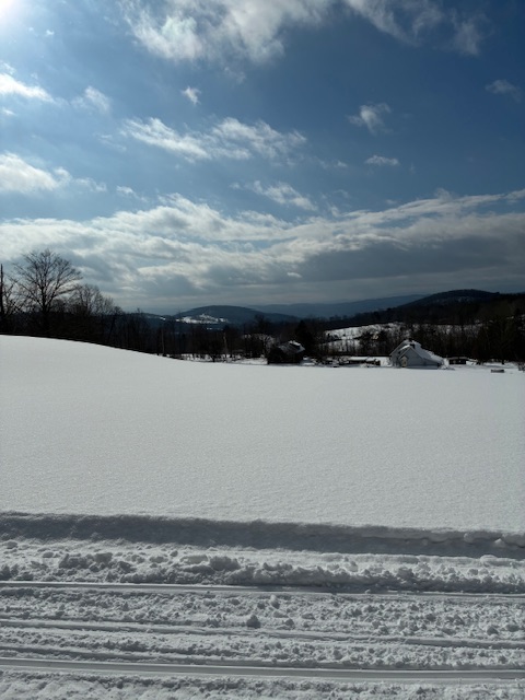
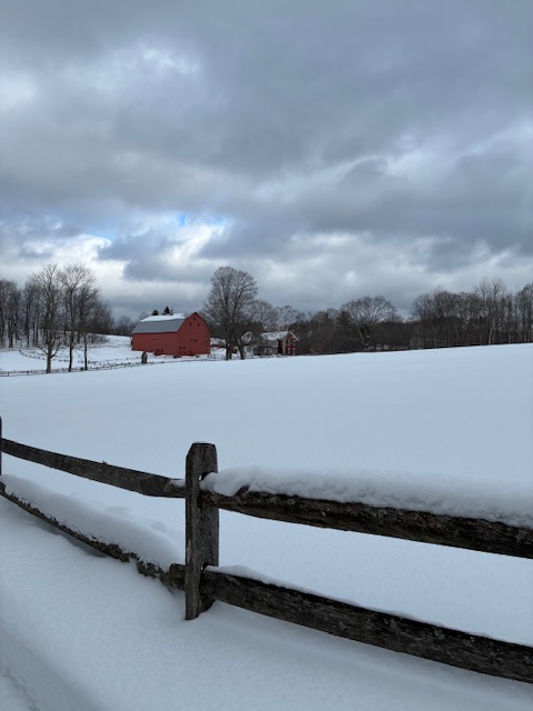
Did a little tour of east central Vermont today. What a beautiful day for outdoor activities.
-
Bust
-
February 2026 Medium/ Long Range Discussion: 150K Salary Needed to Post
GaWx replied to Weather Will's topic in Mid Atlantic
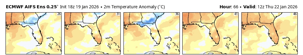
The WB Euro AIFS ensemble means are often the snowiest of the ens means due to having a true snowy bias likely resulting from an algorithm issue at WB although I suppose the issue could be internal at ECMWF (doubtful). This is most easily exhibited by the numerous times (every run) when individual members have blobs of heavy snow well out over the Gulf/Atlantic when temperatures are in the 60s-70s. Even Bastardi has noted this oddity about his company’s own Euro AIFS snow maps! These blobs even show up on all of the ens means although obviously lighter. Notice that no other end snow maps have this oddity. (This isn’t the first issue I’ve seen with WB maps by the way. For example, their Euro Weekly 2m maps are colder than the ecmwf in-house maps.) Example: member 46 (far right) getting heavy snow during hours 60-66 (6Z to 12Z on 1/22/26) on the 18Z 1/19/26 run 200 miles out into the Gulf while temperatures are above normal (70s)! While laughable, it is more importantly indicative of a significant snowy bias on its maps: Actually, this can be seen in subtropical regions throughout the globe. It even shows snow blobs now in Australia during their summer, for example!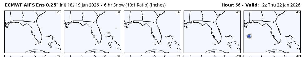
-
Meh-vent.
-
Euro is so frustrating since w heavier precip we’d probably get snow even into the metros w surface temps of 34
-
Can't win em all.
-

Southern MD / Lower Eastern Shore weather discussion
SnowtoRain replied to PrinceFrederickWx's topic in Mid Atlantic
So what's going on, nice rainy Sunday? Any garbage time flakes? -

Central PA Winter 25/26 Discussion and Obs
Ruin replied to MAG5035's topic in Upstate New York/Pennsylvania
notice how every system is a big one then as the event gets closer it just gets weaker 90% of the time


