All Activity
- Past hour
-

October Comes Early: Late September Multi-Hazard Hybrid Storm
weatherwiz replied to WxWatcher007's topic in New England
Just because the lead story was on the storm does not mean it was hyped, majority of the news audience tunes in for weather. Weather is a significant portion of news ratings. Cancelling events ultimately is the decision of the person or people responsible for that decision. Even I year ago I laughed at how schools cancel so easily now, I made a post slamming schools because of closing for a potential wind event last year. However, a post from FXWX swayed my mind a bit and the various research papers I've read in this Weather and Society course I am currently taking has altered my perspective. There is an increasing trend for people to be on the safe side and one of the reasons for these decisions is people comparing risk versus "reward". Also, there is a greater trust in weather forecasts these days which factors in as well. -
 8.06…. Are we done? Doesn’t look like anything else rotating in on radar
 -

October Comes Early: Late September Multi-Hazard Hybrid Storm
Great Snow 1717 replied to WxWatcher007's topic in New England
C'mon for days the lead story on the news was the storm. The hype created panic. Numerous events in the Merrimack Valley area were postponed or cancelled. At no time was any adjustments made to the forecast for the Merrimack Valley area. Yesterday morning TWC had the area in the 2-3 more inches of rain to come area....not even close.. -

Strong Nor'Easter/Hybrid Storm Late September 2026
FPizz replied to Rjay's topic in New York City Metro
I'm at like 2.25" here -

Strong Nor'Easter/Hybrid Storm Late September 2026
weatherpruf replied to Rjay's topic in New York City Metro
it really wasn't much north of monmouth county in nj tbh...if this had been snow it would have been a monmouth ocean special while we struggled to get six inches or so, seen it many times. hope its not a pattern this winter, though not expecting much anyway with this el nino. kinda glad i missed the brunt of it as i hate power outages who doesn't. a few branches down here but nothing to be worried about; worst seemed to be saturday night. never got torrential rains either. lot of people asking wtf around here, but way it goes. better to be prepared, and i had my stuff together if needed. -
18"....6" in one hour
-
Approaching 3” storm total.
-

Strong Nor'Easter/Hybrid Storm Late September 2026
SI Mailman replied to Rjay's topic in New York City Metro
3.6 inch rain total -
October Comes Early: Late September Multi-Hazard Hybrid Storm
weatherwiz replied to WxWatcher007's topic in New England
I don't recall any local TV stations hyping anything up. Like i said, forecast was very well communicated. Multiple days (several really) of communication allowed people to prepare, particularly emergency management and utility companies. Because of the staging and extra resources Eversouce dedicated ahead of time power outages were resolved in a timely manner and this helped keep numbers at a reasonable level. There was also some significant coastal flooding as advertised and you'd have to think those along the coast prepared and anticipated on this and impact the best they could. I don't recall any outlets out there stating any storm impacts being more extreme that what occurred. -
 ed pills cheap: ApexMenMeds - buy ed medication online
 -
October Comes Early: Late September Multi-Hazard Hybrid Storm
Great Snow 1717 replied to WxWatcher007's topic in New England
..but the hype was off the charts...none of the hypemasters on TV offered up an explanation this morning.... -

2026-2027 Record-breaking El Nino
40/70 Benchmark replied to Stormchaserchuck1's topic in Weather Forecasting and Discussion
I don't know how you can emphatically cite how much MC influence there was in 2023, then dismiss any influence of the central basin this season....yes, El Nino is stronger, but it's not omnipotent, as evidenced by the PDO resistance owed to the Japanese warm pool. Anyway, we'll see what happens....good chatting, as always. -
October Comes Early: Late September Multi-Hazard Hybrid Storm
weatherwiz replied to WxWatcher007's topic in New England
There are always going to be areas which either meet forecast expectations, receive greater storm impact than forecast, or end up with lesser impact than forecast. From a forecasting perspective there are many situations where a forecaster can have an idea of where greater impacts/lesser impacts are more likely, however, it becomes a great challenge presenting that and conveying that to the general public. There are also situations where this is highly dependent on small-scale processes related to exact storm evolution. -
2026-2027 Record-breaking El Nino
40/70 Benchmark replied to Stormchaserchuck1's topic in Weather Forecasting and Discussion
You mean 1.2? I just showed you the precip anomalies....they are higher in region 3.4 than in regions 3 and 1.2. I do agree that the forcing is sheared due to the warmth on the eastern flank of ENSO, but it's not as large of an area as the central node of warmth. Again, all I am arguing for is a nice stretch mid season when that central area takes hold....not a 2002-2003 or 2009-2010 like outcome. -

October Comes Early: Late September Multi-Hazard Hybrid Storm
CoastalWx replied to WxWatcher007's topic in New England
It was. That area always floods. -
October Comes Early: Late September Multi-Hazard Hybrid Storm
Great Snow 1717 replied to WxWatcher007's topic in New England
That is true for some areas but the storm was a bust in the Merrimack Valley area. -

2026-2027 Record-breaking El Nino
bluewave replied to Stormchaserchuck1's topic in Weather Forecasting and Discussion
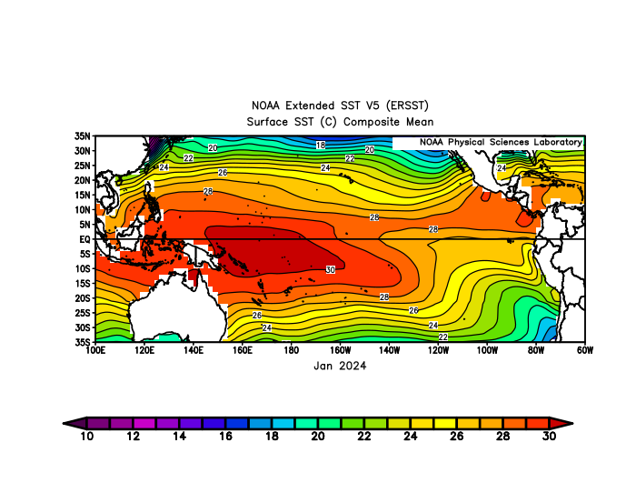
The actual SSTs late this fall into winter may continue to be near +30C in spots along the West Coast of Southern Mexico and Central America. During a much weaker El Niño in 2023-2024 they were at +29C. Plus the magnitude of the warmth in Nino 1-2 and 3 are forecast to pull the forcing east. This happened in 1997-1998 with much cooler SSTs.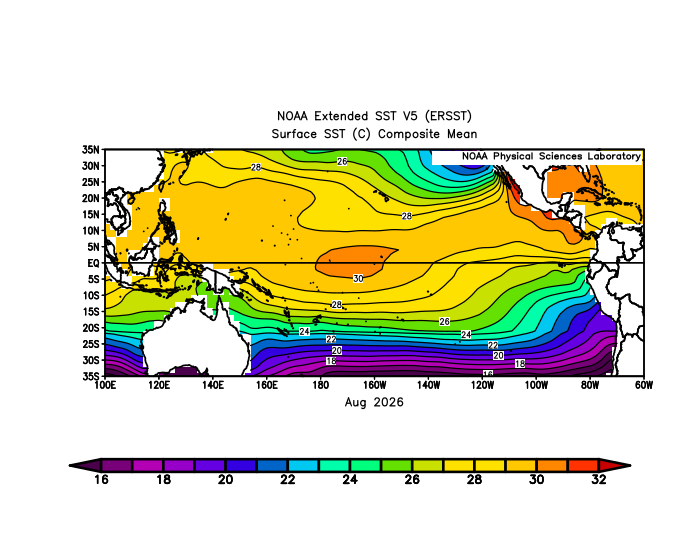
-
2026-2027 Record-breaking El Nino
40/70 Benchmark replied to Stormchaserchuck1's topic in Weather Forecasting and Discussion
Let me be clear....I agree with Chris that this season will be east-based as far as temp anomalies...warmth will be more prevalent; I'm just arguing that there will be some favorable windows during the 2nd half. I'm not arguing for a Modoki season or anything. -
October Comes Early: Late September Multi-Hazard Hybrid Storm
dryslot replied to WxWatcher007's topic in New England
Pretty dreary out today but we salvaged a decent weekend up here, 0.64" overnight with a mainly dry weekend. -
October Comes Early: Late September Multi-Hazard Hybrid Storm
Great Snow 1717 replied to WxWatcher007's topic in New England
Where is the 1.94 reported from? -

October Comes Early: Late September Multi-Hazard Hybrid Storm
Layman replied to WxWatcher007's topic in New England
0.42" Sat, 0.89" Sun and 0.76" so far today. 2.07" for the total through 10am. I sit pretty equidistant from both Manchester (E) and Methuen (NE) at about 30-35 miles. -
Something had to change though. It has been a decade of futility for us western folks. I will take my chances with some wound up bombs for once.
-
2026-2027 Record-breaking El Nino
40/70 Benchmark replied to Stormchaserchuck1's topic in Weather Forecasting and Discussion
These longitudes are all in 3.4, BTW...should have placed the ENSO regions on here. I will go back to do so in my blog. Big thanks to @BlizzardWxfor making all of these features available on Satellitewx.com. https://satellitewx.com/ -
It is true that 6 of the last 7 HECS storms came in a nino but those are such super rare events anyways. We've had plenty of SECS/MECS events in other enso states, at least until recently. Recently we've not had big snowtorms in ANY enso state. The last 2 Nino's didn't produce a significant snow for Baltimore either. If this winter does not that would be 3 in a row. At some point maybe you just have to accept a difficult truth.
-
Time to get this thread going again. I still think it'll be a super mild winter. While the CFS and some AI stuff keeps going cold, I believe it's feedback on SUPER Nino. They are missing the flood of warmth in the ATMO. ECMWF trended warmer. Finally got a few minutes to look at precip. Obviously the last several weeks were nuts at work with a 100-year outlier extended heat-wave. February precip chart is my dream. Oh wait! You think I need my head examined for cheering BN precip? Reembmer snow holds much less liquid than rain. We got AN rain to our southeast with BN right over Tenn. I infer southern track storm systems. I infer snow in Feb. Temps are only normal, but that's enough with variability in Feb. 500 mb (not shown) screams southern track too. ECMWF February precip, Sept. 5 forecast