All Activity
- Past hour
-
Little bit of rain with these latest cells.
-
.03 Hopefully the forecast for around an inch tomorrow night into Sunday comes to fruition
-
Not a drop.
-
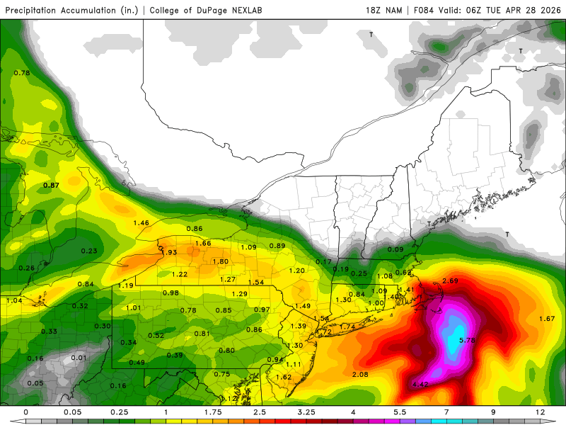
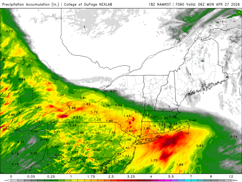
Run off NAM parameters and replacing the NAM. post the others that are totally dry
-
How about Rufus?

-
Nam vs world . Can see the dry air press even on these “wet” runs . 0.00
-
-
Now post 12k and H cubed
-

2026-2027 El Nino
jaxjagman replied to Stormchaserchuck1's topic in Weather Forecasting and Discussion
This looks like another Rossby Wave west of the IDL,while some RMMS are hinting the MJO could possibly go back into the WP,the MJO signal seemingly is getting destructive interference from this and is into the WH.I see the CFS is already showing another strong WWB but be carefulll looking at this or any models,that WWB last time wasnt as strong east of the IDL and was more or less picked up at times by the Rossby Wave train. -
Had our first 90 degree day as we hit 90.5 this afternoon. Dew point in the 50's made it tolerable in the shade.
-
3k not backing down. Looks great.
-
It cleared up in the ATL area this afternoon. Beautiful day! Rain tomorrow looking a little more promising. Fingers crossed..some should get a decent amount.
-
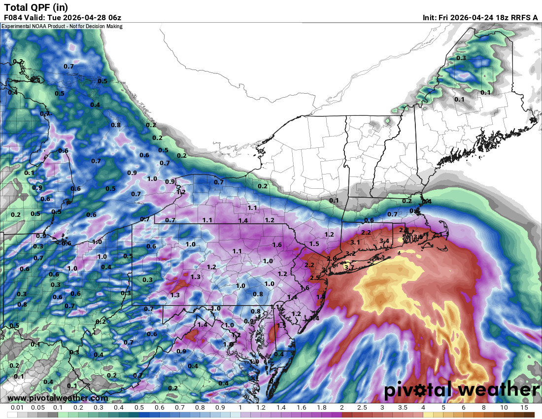
A cool and wet weekend lies ahead. Highs will reach only the lower 50s tomorrow and the middle and upper 50s on Sunday. Periods of rain are likely on tomorrow into Sunday. Rainfall amounts of 0.50"-1.50" with a few locally higher amounts are likely across the region. Beyond the weekend, temperatures will likely remain generally below normal for the remainder of April. May could also open with cooler than normal conditions. The ENSO Region 1+2 anomaly was +1.8°C and the Region 3.4 anomaly was +0.5°C for the week centered around April 15. For the past six weeks, the ENSO Region 1+2 anomaly has averaged +1.43°C and the ENSO Region 3.4 anomaly has averaged +0.15°C. El Niño conditions will likely develop during late spring or early summer. The SOI was -10.82 today. The preliminary Arctic Oscillation (AO) was -1.231 today. Based on sensitivity analysis applied to the latest guidance, there is an implied near 93% probability that New York City will have a warmer than normal April (1991-2020 normal). April will likely finish with a mean temperature near 55.3° (1.6° above normal). Supplemental Information: The projected mean would be 2.3° above the 1981-2010 normal monthly value.
-

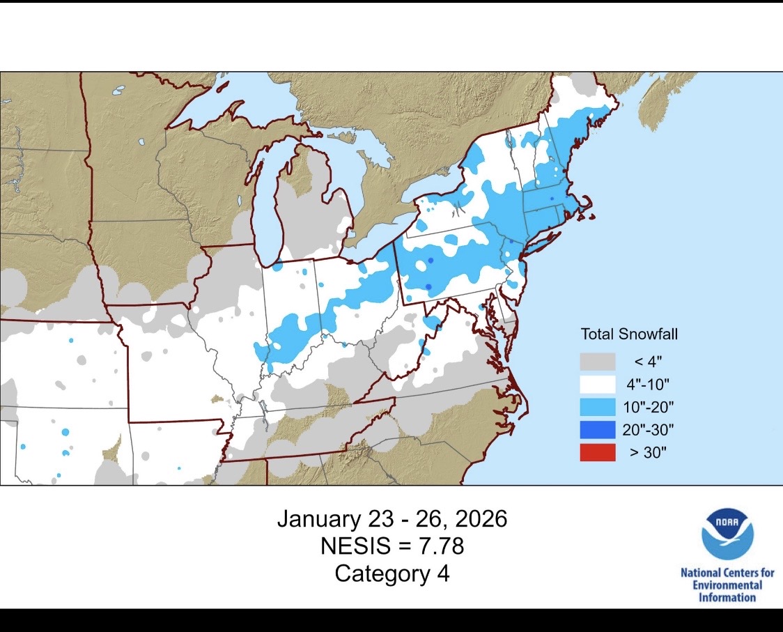
It's time to grade Winter 2025-26(now that it's actually over)
WxUSAF replied to CAPE's topic in Mid Atlantic
Jan 25 gets a Cat 4! Nice!
-
I don't think it's rained at all here.
-
10/10 weather the last couple days. Disappointed about the weekend forecast, but getting that 3rd nice day in a row is not usually easy here until we get to May.
- Today
-
Picture perfect April weather after the precipitation fail here yesterday. Low 60s and a deep blue sky. MTD Precip MSP: 1.96” YTD Precip MSP: 5.40”
-
Sun came back out. Neither the NWS nor the WeatherBug radars seem to be all that accurate as to where the rain is actually hitting the ground.
-
Pretty good couplet headed towards New Castle Indiana on the nose of a baby bow thats Tor warned right now. Thats a not so small town.
-
Close but nada. High 76, 73 now.
-
Raindrops on the sidewalk.
-
Thunder to the south
-
Smells like rain but no precip yet. Overcast plus the low dewpoint making it feel downright cool.
-
This forum has really died out. Decent chance at some severe weather in NE TX this evening. Storms in SE OK should move into NE TX. May be more of a linear wind/hail threat, but isolated tornado threat with any cell that can form/stay isolated and ahead of the outflow boundary.
-
Yes the last few runs the GFS develops a cap in MID TN Into the east,but we'll see soon enough how strong that cap actually is as the, LLJ kicks something like 35-45 kts,that cap might not materialize as shown.Might be picking shit from cherry blossoms other wise with severe..lol On the other hand the last few runs could be a better severe threat even early Wed,maybe nocturnal if the shortwave around the MO/Valley is real what the Euro is showing