All Activity
- Past hour
-

Central PA Winter 25/26 Discussion and Obs
pasnownut replied to MAG5035's topic in Upstate New York/Pennsylvania
I'm turnin my frown updside down. Despite the dud for this upcoming weekend, last few weeks have been and have felt like true winter. Been a long time, and I'm enjoying every day we have snowpack. Looks like pattern relaxes enough moving forward, that chances for clippers and maybe a well timed NS/SS event could happen. Stays cold enough for snow to hold. Lets enjoy what we have and not worry too much about what the next one looks like. It'll come. Till then....enjoy. FWIW my car broke down this morning. Might be major, wont know till next week. Cant fret about it. Gonna b what its gonna b. -

Possible coastal storm centered on Feb 1 2026.
Wxbear25 replied to Typhoon Tip's topic in New England
I was thinking the song, thats what I was paraphrasing before haha But yeah, thats a thing too -

The “I bring the mojo” Jan 30-Feb 1 potential winter storm
NorthHillsWx replied to lilj4425's topic in Southeastern States
It’s time to start watching CAMs and that’s the issue- they are the most variable right now. Definitely feel western NC and upstate SC are pretty locked in to good snow, midland SC looks to be trending positively and coastal NC seems set with a good to great event. Triad to triangle to 95 corridor is where the question marks are greatest -

The “I bring the mojo” Jan 30-Feb 1 potential winter storm
SnowGoose69 replied to lilj4425's topic in Southeastern States
Yeah, I mean even places like Stone Mountain and Norcross could get like 3-4 from this with just a marginal west bump. The airport though or Marietta I think needs quite a bit of help to exceed 2. -
Possible coastal storm centered on Feb 1 2026.
Wxbear25 replied to Typhoon Tip's topic in New England
Careful, if it gets any hotter and heavier in here, we might have to start worrying about changing to rain instead of a whiff -

Possible coastal storm centered on Feb 1 2026.
weatherwiz replied to Typhoon Tip's topic in New England
Lots of disturbing posts today, makes me wonder if some are suffering from too much carbon monoxide intake. Might need to clear snow away from outside vents? -

The “I bring the mojo” Jan 30-Feb 1 potential winter storm
Droessl replied to lilj4425's topic in Southeastern States
RAH still holding strong!
-
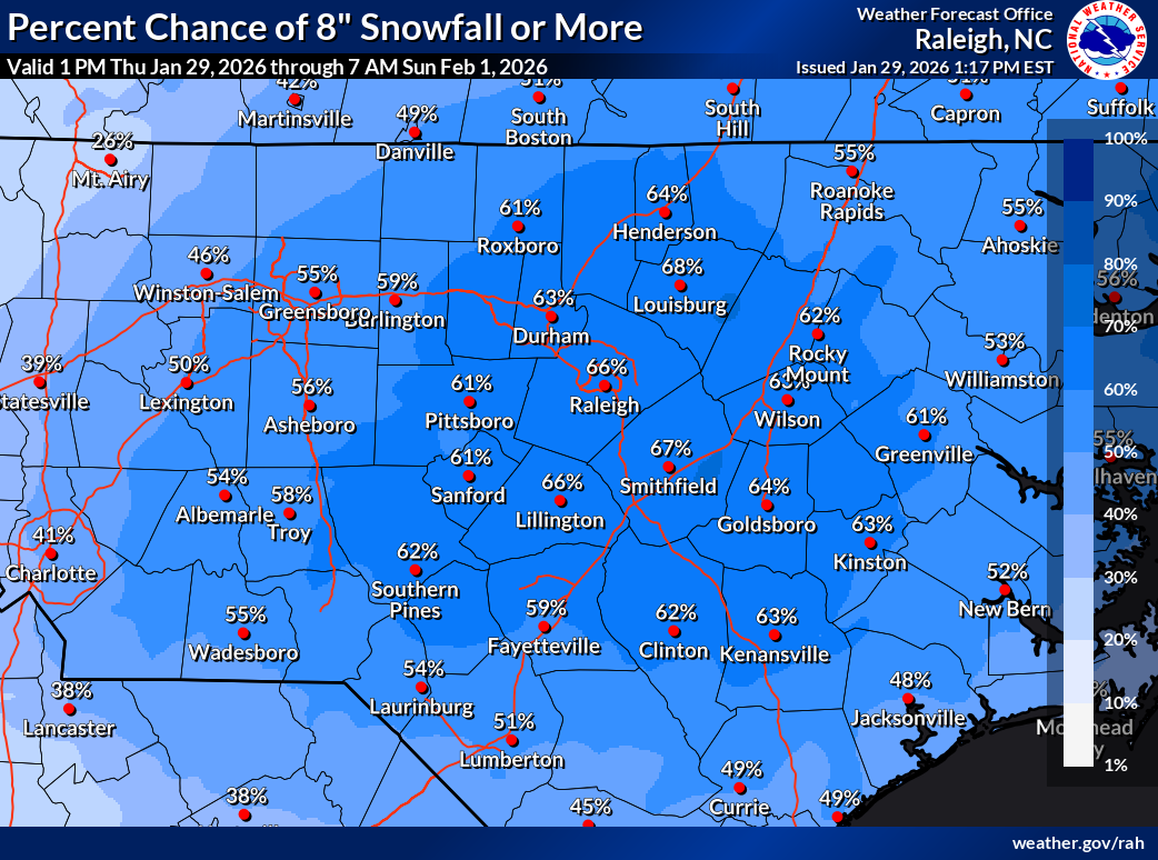
This is from Ross, a Met from RIC area based on history this is typically when we reach our qpf nadir before models bump things up some. atypical storm sure. but if we're going with history this is our bottom
-

Possible coastal storm centered on Feb 1 2026.
512high replied to Typhoon Tip's topic in New England
Old TV show...classic -

The “I bring the mojo” Jan 30-Feb 1 potential winter storm
BlizzardNole replied to lilj4425's topic in Southeastern States
How disruptive would 8-12" be in that area? I can't imagine they have many plows? Our daughter is in Morehead City. Sorry of the off-topic SE forum folks! Hope you get a good storm. -
Possible coastal storm centered on Feb 1 2026.
Wxbear25 replied to Typhoon Tip's topic in New England
-

The “I bring the mojo” Jan 30-Feb 1 potential winter storm
Awilson replied to lilj4425's topic in Southeastern States
Heyyyy I’m from Glen burnie, been on the coast for 4 years now.(Sneads Ferry)I think in those 4 years maybe 2 inches of snow. -

The “I bring the mojo” Jan 30-Feb 1 potential winter storm
sakau2007 replied to lilj4425's topic in Southeastern States
yes. NE ATL should do better than NW ATL from this storm... although anything is possible a heavier snow shower could set up over cobb county and dump an extra 1-2 inches and miss places like lawrenceville and buford. but if you had to bet, you'd have to bet on the 85 corridor getting more than the 75 corridor north of town. -

The “I bring the mojo” Jan 30-Feb 1 potential winter storm
stormwatcherJ replied to lilj4425's topic in Southeastern States
We'll see what the Euro says, but as of this morning my NWS station's discussion called for 2-4 inches in my neck of the woods, and that seems about right. I don't think much has changed. So under 2 i'll be a bit disappointed.. over 4 and I'll be thrilled! -

Possible coastal storm centered on Feb 1 2026.
40/70 Benchmark replied to Typhoon Tip's topic in New England
? -
Possible coastal storm centered on Feb 1 2026.
40/70 Benchmark replied to Typhoon Tip's topic in New England
You ask, I'll tell -
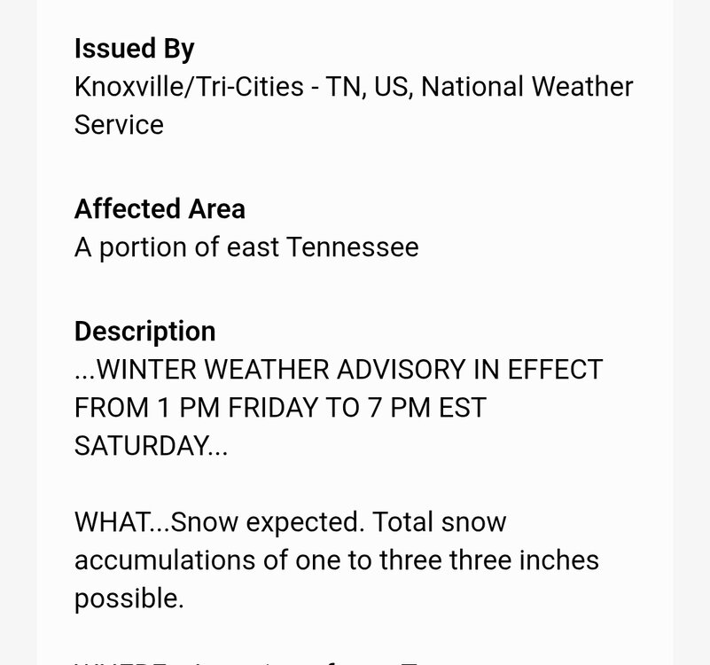
If you read the WWA verbatim on my phone it says expect 1 to 33 inches lol (that would be hilarious if it wasn't a glitch).
-

Possible coastal storm centered on Feb 1 2026.
dendrite replied to Typhoon Tip's topic in New England
Don’t ask, don’t tell? -
Possible coastal storm centered on Feb 1 2026.
weatherwiz replied to Typhoon Tip's topic in New England
west, west baby. Come west to me baby -
Possible coastal storm centered on Feb 1 2026.
Wxbear25 replied to Typhoon Tip's topic in New England
Semper Fi, and thank you for your service. I'm guessing you've never been a fan of Alice's Restaurant then haha -
Possible coastal storm centered on Feb 1 2026.
40/70 Benchmark replied to Typhoon Tip's topic in New England
Hey, I served in the Marines...throw me a bone, here. -
Will do!!
-

The “I bring the mojo” Jan 30-Feb 1 potential winter storm
wncsnow replied to lilj4425's topic in Southeastern States
It's been very consistent for days with its general footprint. Only minor tweaks since early this week. -
I’m not a Fox News viewer (Fox Weather, on the other hand, is great) or defender, but Fox News wishes it could be as unhinged as social media weather wannabes. They make Fox News look like Shakespeare. .
-
Richmond Metro/Hampton Roads Area Discussion
Berlin1926 replied to RIC Airport's topic in Mid Atlantic
3-5 360 south