All Activity
- Past hour
-
HOLY MIRACLE!!!!!!!!!!!!!!!!!! We picked up some showers overnight and this morning. 0.27". I will take it.
-
I know AA county has gotten less than N/W areas but still a decent amount with more to come? CoCoRAHS seems like 0.75-1.75” north to south through your county.
-
2.71" wonderful total! Hopefully another 2 inches thru Monday.
-

Central PA Spring 2026 Discussion/Obs Thread
mahantango#1 replied to Voyager's topic in Upstate New York/Pennsylvania
Remember your bigger then that creature, -

Central PA Spring 2026 Discussion/Obs Thread
pawatch replied to Voyager's topic in Upstate New York/Pennsylvania
47 degrees and windy. .35” of rain Coal stove feels nice this morning. -
Yup. We'll be getting those amoutns this weekend.....would be bone dry after that if that's right.
-
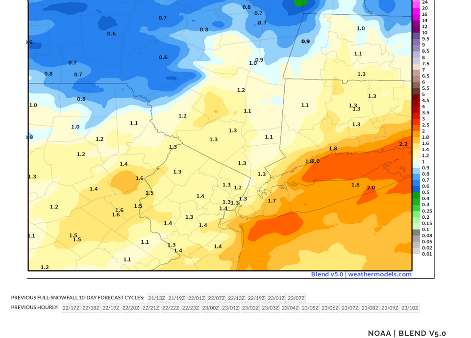
Latest NBE: My thinking is that most of the area will see a general 1.00"-1.50" with some locally higher amounts. The NBE has lowered the top amounts while raising the lower amounts. The 0.50" figure will be confined to locations farther from the NYC area than had been my thinking last evening. The 6z GFS, 0z GGEM and 0z AIFS are in good agreement. The 0z ECMWF became notably wetter. However, it is an outlier among the operational models. The key to achieving higher amounts, particularly those on the ECMWF, would be convective activity, possibly training thunderstorms. At present, most of the convective activity will likely take place south of the NYC region
-
feeling chilly had the heat on last night wore a sweatshirt my kind of temps.
-
but it will be damp showers and dreary i might be tempted to go out and do my walk considering rain will be light and spotty
-
This would keep the webbed handed gardener away for a bit
-
Same thing here but still severe drought lol. I knew this was going to be the case in my area. Models were hinting at a screw zone in this area.
-
It was still backed up to the Severn river bridge at 9pm last night. Insanity.
-

Central PA Spring 2026 Discussion/Obs Thread
Voyager replied to Voyager's topic in Upstate New York/Pennsylvania
I was going to go out back and have a smoke, but this little stinker altered my plans...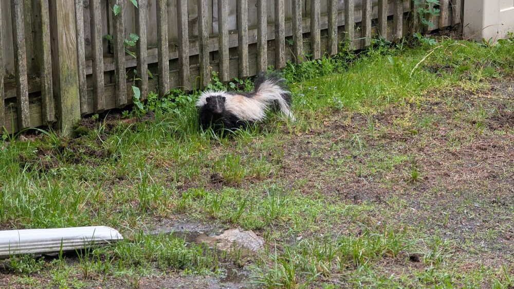
-
Columbia— as of Saturday morning: Another 1.3” (!!) Fri 7pm-7am Sat bringing total for this event so far to 3.04”. And 4.20” for May so far.
-
All models running drier at 6z and radar looks putrid. Today is not looking like a washout.
-
It is not all sunshine and rainbows up here, literally. While we are happy that the rain we have gotten is helping, the lack of any sun for the last 3 days is really taking a toll on a lot of people. And it does not look to change in the near future.
-
This is nice too for actual values. IEM :: Hourly Precip Accumulator Station ID Station Name Midnight 5/22, 11 PM 5/23, 1 AM 1 Hour 5/23, 12 AM 5/23, 1 AM 3 Hour 5/22, 10 PM 5/23, 1 AM 6 Hour 5/22, 7 PM 5/23, 1 AM 12 Hour 5/22, 1 PM 5/23, 1 AM 1 Day 5/22, 1 AM 5/23, 1 AM 2 Day 5/21, 1 AM 5/23, 1 AM 3 Day 5/20, 1 AM 5/23, 1 AM 7 Day 5/16, 1 AM 5/23, 1 AM 30 Day 4/23, 1 AM 5/23, 1 AM 90 Day 2/22, 12 AM 5/23, 1 AM 365 Day 5/23, 1 AM 5/23, 1 AM ASJ AHOSKIE_TRI_COU 0.02 0.02 0.02 0.02 0.02 0.03 0.16 0.16 0.16 2.64 7.04 28.71 VUJ ALBEMARLE 0.00 0.00 0.46 0.54 0.54 0.55 0.90 0.90 0.90 2.34 4.63 30.70 RHP ANDREWS-MURPHY_AIRPORT 0.00 0.00 0.00 0.00 0.00 0.00 0.00 0.00 0.00 0.01 0.01 23.46 GEV ASHE_COUNTY_ARPT 0.02 0.02 0.30 0.40 0.41 0.48 1.27 1.37 1.37 2.68 5.53 23.62 HBI ASHEBORO_MUNI_ARPT 0.04 0.04 0.18 0.19 0.19 0.20 0.39 0.39 0.39 2.16 5.34 26.22 AVL ASHEVILLE_MUNICIPAL_(ASOS) T T T 0.29 0.62 0.85 0.93 1.14 1.14 3.25 6.08 37.88 NJM Bogue Field 0.01 0.01 0.01 0.01 0.01 0.10 0.10 0.10 0.10 1.31 3.21 27.31 BUY BURLINGTON-ALAMANCE_REG_(ASOS) 0.01 0.01 0.01 0.01 0.01 0.02 0.29 0.29 0.29 1.67 4.94 42.69 CLT Charlotte / Douglas 0.02 0.02 0.18 0.45 0.50 0.69 1.52 1.52 1.52 3.96 6.79 31.48 NKT CHERRY_POINT_MCAS T T 0.01 0.01 0.12 0.15 0.34 0.34 0.34 4.47 7.60 47.87 CTZ CLINTON 0.00 0.00 0.00 0.00 0.07 0.07 0.07 0.07 0.07 2.52 4.28 31.32 CPC COLUMBUS_CNTY_MUNI_ARPT 0.00 0.00 0.00 0.00 0.06 0.13 0.13 0.13 0.15 2.01 3.96 36.40 JQF CONCORD 0.02 0.02 0.14 0.25 0.25 0.38 0.39 0.39 0.39 1.23 1.33 6.02 ONX Currituck 0.00 0.00 0.01 0.01 0.01 0.01 0.01 0.01 0.01 1.62 1.87 22.95 2DP Dare County Gunnery Range 0.00 0.00 0.00 0.00 T T T T T 2.18 5.66 13.39 TQV Durham - Duke North Heliport 0.00 0.00 0.00 0.00 0.00 0.12 0.47 0.47 0.47 1.25 3.59 28.22 EDE EDENTON_NORTHEA 0.00 0.00 0.00 0.00 0.00 0.00 0.00 0.00 0.00 1.34 4.44 27.49 ECG Elizabeth City 0.01 0.01 0.01 0.01 0.01 0.01 0.12 0.12 0.12 1.50 6.33 38.02 EYF ELIZABETHTOWN/CURTIS_BROWN_FIELD 0.00 0.00 0.00 0.00 0.10 0.20 0.20 0.20 0.20 2.58 4.41 29.68 7W6 Engelhard 0.00 0.00 0.00 0.00 0.00 0.00 0.00 0.00 0.00 1.89 4.98 23.02 HRJ ERWIN/HARNETT_COUNTY_ARPT 0.00 0.00 0.01 0.05 0.05 0.05 1.01 1.01 1.01 2.77 4.57 27.11 FAY Fayetteville 0.39 0.39 0.40 0.47 0.47 0.47 0.47 0.47 0.47 2.39 5.09 32.28 FBG FORT_BRAGG/SIMMONS T T T T T T T T T 2.40 4.21 36.39 1A5 FRANKLIN 0.00 0.00 0.00 0.06 0.13 0.46 0.79 0.79 0.79 2.81 5.86 25.82 AKH GASTONIA_MCPL_(ASOS) 0.02 0.02 0.22 0.67 0.72 1.18 1.18 1.18 1.18 4.31 7.15 36.21 GWW GOLDSBORO-WAYNE_MUNI_ARPT 0.00 0.00 0.38 0.52 0.52 0.52 0.52 0.52 0.52 2.58 4.87 29.19 GSO GREENSBORO/PIEDMONT_(ASOS) 0.08 0.08 0.27 0.28 0.28 0.61 0.73 0.73 0.73 1.48 4.71 36.14 HSE HATTERAS_(ASOS) 0.01 0.01 0.01 0.01 0.01 0.06 0.06 0.06 0.06 2.80 7.07 54.24 HNZ HENDERSON-OXFORD_ARPT 0.08 0.08 0.08 0.08 0.08 0.09 1.40 1.40 1.40 1.58 3.45 26.57 HKY HICKORY_REGIONAL_(ASOS) 0.01 0.01 0.15 0.39 0.49 0.94 1.10 1.10 1.10 1.97 4.10 31.27 OAJ JACKSONVILLE_(AWOS) T T T T 0.17 0.18 0.18 0.18 0.18 2.03 7.98 39.94 NR02 Jordan Field 0.00 0.00 0.00 0.00 0.00 0.00 0.00 0.00 0.00 0.00 0.00 0.00 DPL KENANSVILLE/DUPLIN_COUNTY 0.01 0.01 0.02 0.07 0.17 0.17 0.17 0.17 0.17 3.61 8.76 54.58 FFA KILL_DEVIL_HILLS 0.00 0.00 0.00 0.00 0.00 0.00 0.00 0.00 0.00 1.46 4.36 18.30 ISO KINSTON/STALLINGS 0.00 0.00 0.00 0.00 0.00 0.00 0.00 0.00 0.00 0.74 1.19 7.83 MEB LAURINBURG-MAXTON_ARPT_(ASOS) 0.07 0.07 0.26 0.27 0.27 0.27 0.27 0.27 0.27 1.79 4.20 19.43 EXX LEXINGTON_DAVIDSON_COUNTY_AIRP 0.03 0.03 0.22 0.29 0.29 0.74 1.00 1.00 1.00 2.22 5.69 21.51 IPJ LINCOLNTON 0.07 0.07 0.19 0.39 0.42 0.88 1.20 1.20 1.20 2.80 5.71 28.27 LHZ LOUISBURG/FRANKLIN_CNTY_ARPT 0.20 0.20 0.27 0.27 0.27 0.30 0.43 0.57 0.57 2.14 4.44 24.99 LBT Lumberton 0.00 0.00 0.04 0.04 0.06 0.06 0.06 0.06 0.06 2.55 4.77 29.92 HFF MACKALL_AAF 0.19 0.19 0.19 0.21 0.21 0.21 0.21 0.21 0.21 2.98 5.13 32.20 MQI MANTEO/DARE_CO_RGNL 0.00 0.00 0.00 0.00 0.00 0.05 0.05 0.05 0.05 1.28 5.47 31.17 EQY MONROE_AIRPORT_(ASOS) 0.02 0.02 0.15 0.72 0.75 0.81 1.81 1.81 1.81 4.65 6.38 30.42 MRN MORGANTON-LENOIR_AIRPORT 0.01 0.01 0.22 0.56 0.82 1.24 1.51 1.51 1.51 2.89 4.93 29.49 W40 Mount Olive 0.04 0.04 0.15 0.55 0.65 0.65 0.65 0.65 0.65 2.93 5.06 30.56 MWK MOUNT_AIRY/SURRY_COUNTY_APRT 0.04 0.04 0.06 0.06 0.08 0.41 0.45 0.45 0.45 1.46 4.00 39.89 EWN NEW_BERN/CRAVEN_CO_(ASOS) T T T 0.01 0.03 0.05 0.05 0.05 0.05 1.88 6.69 29.62 NCA NEW_RIVER_MCAS 0.00 0.00 0.00 0.00 0.01 0.70 0.70 0.70 0.70 2.04 4.99 23.68 UKF NORTH_WILKESBORO/WILKES_CNTY 0.06 0.06 0.20 0.34 0.38 0.44 0.44 0.44 0.44 1.17 3.65 24.04 NBT Piney Island 0.00 0.00 0.00 0.00 0.00 0.00 T T T 0.07 2.23 21.98 PGV PITT-GREENVILLE_APRT 0.00 0.00 0.00 0.00 0.01 0.01 0.01 0.01 0.01 1.62 5.55 34.25 POB POPE_AFB 0.02 0.02 0.03 0.05 0.05 0.05 0.05 0.05 0.05 1.68 3.81 31.32 RDU Raleigh / Durham T T T T T 0.23 0.70 0.70 0.70 1.96 5.54 34.48 SIF Reidsville 0.11 0.11 0.14 0.14 0.14 0.21 0.23 0.23 0.23 1.18 2.32 23.69 IXA Roanoke Rapids 0.01 0.01 0.01 0.01 0.01 0.02 0.26 0.26 0.26 3.00 5.80 20.86 RZZ ROANOKE_RAPIDS_(ASOS) 0.00 0.00 0.00 0.00 0.00 0.00 0.00 0.00 0.00 0.00 0.00 0.00 RCZ ROCKINGHAM 0.03 0.03 0.30 0.42 0.42 0.42 0.42 0.42 0.42 2.17 3.90 27.39 RWI ROCKY_MOUNT-WILSON_(ASOS) 0.04 0.04 0.07 0.07 0.07 0.08 0.34 0.34 0.34 2.40 6.79 30.70 RUQ ROWAN_COUNTY_AIRPORT 0.01 0.01 0.15 0.22 0.22 0.34 0.61 0.61 0.61 1.62 3.56 17.30 TDF ROXBORO 0.06 0.06 0.06 0.06 0.06 0.09 0.25 0.39 0.39 1.51 3.89 24.91 FQD RUTHERFORDTON 0.00 0.00 0.09 0.51 0.92 1.22 1.87 1.87 1.87 3.30 5.25 30.85 TTA Sanford - Lee County 0.00 0.00 0.00 0.00 0.00 0.33 0.91 0.91 0.91 2.73 5.06 33.76 GSB SEYMOUR-JOHNSON_AFB 0.00 0.00 0.00 0.00 0.00 0.00 0.00 0.00 0.00 0.00 2.43 27.49 EHO SHELBY_MUNI_ARPT 0.00 0.00 0.15 0.26 0.44 1.15 1.19 1.19 1.19 3.35 6.64 33.60 SCR Siler City 0.01 0.01 0.01 0.01 0.01 0.03 1.16 1.16 1.16 2.02 3.79 27.72 5W8 Silver City 0.00 0.00 0.00 0.00 0.00 0.00 0.00 0.00 0.00 0.00 0.00 0.00 MRH SMITH_FIELD/BEAUFORT_(ASOS) 0.04 0.04 0.17 0.17 0.17 0.62 0.92 0.92 0.92 6.79 9.21 42.54 JNX SMITHFIELD 0.00 0.00 0.15 0.21 0.21 0.23 0.34 0.34 0.34 1.79 3.50 23.30 SOP SOUTHERN_PINES_AWOS 0.00 0.00 0.00 0.00 0.00 0.00 0.00 0.00 0.00 T T 16.06 SUT SOUTHPORT/BRUNSWICK 0.00 0.00 0.00 0.00 0.00 0.03 0.03 0.03 0.03 1.29 4.13 35.94 SVH STATESVILLE 0.05 0.05 0.12 0.21 0.38 0.78 0.98 0.98 0.98 2.11 5.38 24.87 24A Sylva 0.00 0.00 0.00 0.08 0.26 0.32 0.71 0.74 0.74 2.91 6.09 33.49 ETC Tarboro 0.00 0.00 0.00 0.00 0.00 0.00 0.00 0.00 0.00 1.25 4.10 20.90 AFP Wadesboro 0.13 0.13 0.47 0.59 0.59 0.59 0.61 0.61 0.61 2.70 4.03 21.38 ACZ Wallace 0.00 0.00 0.00 0.00 0.01 0.26 0.26 0.26 0.26 2.14 4.71 28.08 OCW WASHINGTON/WARREN_FIELD_APRT 0.00 0.00 0.13 0.13 0.13 0.13 0.13 0.13 0.13 1.93 4.40 25.34 TNB WATAUGA_CNTY_HOSP_HELIP 0.05 0.05 0.23 0.33 0.51 0.72 1.52 1.54 1.54 2.79 6.62 36.72 IGX WILLIAMS_AIRPORT_(ASOS) 0.00 0.00 0.00 0.00 0.00 0.00 0.00 0.00 0.00 0.00 0.00 0.00 MCZ Williamston 0.00 0.00 0.00 0.00 0.00 0.00 0.00 0.00 0.00 1.46 5.64 28.35 ILM Wilmington Intl 0.00 0.00 0.00 0.00 0.88 1.59 1.67 1.67 1.67 3.81 7.10 43.98 INT WINSTON-SALEM/SMITH_(ASOS) 0.00 0.00 0.00 0.00 0.00 0.00 0.00 0.00 0.00 0.00 3.51 25.08
-
You can use this---https://water.noaa.gov/precip
- Today
-
Rant: who the fuck decides not to have the bay bridge open 3 lanes East for a Memorial Day weekend? 14 mile back up thanks to that.
-
Rainy on the lower eastern shore. Hoping it’s not an all day washout but if it is there are other things to do
-

Central PA Spring 2026 Discussion/Obs Thread
Mount Joy Snowman replied to Voyager's topic in Upstate New York/Pennsylvania
Another .33” of precip, which brings me to a total of exactly one inch over the last three days. Let’s see how much we can pile on through the holiday weekend. Current temp of 49 is the low. Sure seems like MDT’s min max record of 54 is going down. Edit: Perhaps not, as it seems MDT’s temp was stuck right around 54 for hours around midnight. We’ll have to see how things round off but record seems safe. Damn midnight highs. -
2.62" for the event so far.
-

Central PA Spring 2026 Discussion/Obs Thread
NepaJames8602 replied to Voyager's topic in Upstate New York/Pennsylvania
41 degrees and rain here in the Poconos. Is it November? Lol. -
I love the RainDrop app. It is amazing on accuracy. https://www.raindrop.farm
-
We are up to 1.43” so far. Decided to open our windows and not turn on the tv this morning. Been listening to the beautiful sounds of the rain, birds chirping, and the light breeze bringing music from the chimes. God is blessing us with His voice through nature. Doesn't get any better.