All Activity
- Past hour
-
A windy, cloudy dud today. now at 50°
-
I hate warmth
-
Yes every year we get blocking in April
-
You hate 70s??
-
So far as regards the effects on Nino 3.4 SSTa, it’s been all bark and little or no bite with it still at ~-0.2 to -0.3C. It should resume warning shortly, but it’s done none the last 3 weeks.
-
76 here.
-
Not here.
-

2026-2027 El Nino
snowman19 replied to Stormchaserchuck1's topic in Weather Forecasting and Discussion
-
The latest official weekly for 3.4 was semi-stalled at -0.3 after being -0.2 the week before and -0.3 two weeks before: https://www.cpc.ncep.noaa.gov/data/indices/rel_wksst9120.txt
-
I thought it was smoky round here.

-
Thought today and tomorrow was gonna be miss north for anything exciting, but looks like a healthy storm about to run through.
-
71. Lovin it.
-
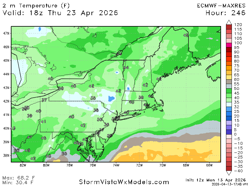
40's are normal for April?
-
Its normal for April. I hate the warmth.
-
That line dried up hilariously fast.
-
What’s fucked up is that people aren’t cheering for 70s, they’re actually rooting for 40s and rain. In April.
-
Good luck chief
-
LOL


- 387 replies
-
- 1
-

-
- april showers bring may..
- rain
- (and 2 more)
-
@ineedsnow

-
Pretty good storm. Lots of wind, continuous throughout the storm
-
Yep bangers both days
-
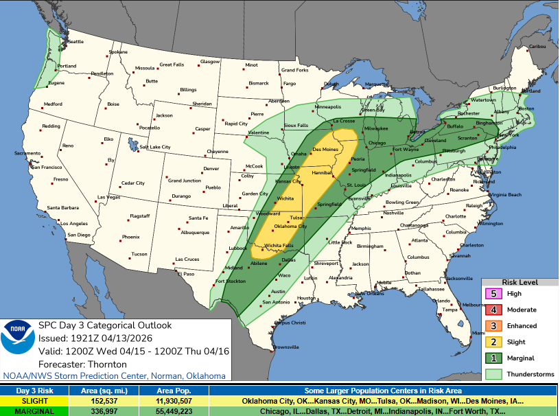
oh come on are you kidding me? Got the marginal risk but got cutoff right at the border
-
Here's where we could be sitting on Friday, with current forecast values. Hottest spring on record to date: Columbus, OH; Cincinnati, OH; all of Kentucky; Evansville, IN; and Springfield, MO. Top 2-5: Kansas City, MO; Des Moines, IA; Waterloo, IA; Moline, IL; Rockford, IL; Peoria, IL; Springfield, IL; Columbia, MO; Indianapolis, IN; South Bend, IN; Fort Wayne, IN; Toledo, OH; Dayton, OH; Mansfield, OH; Cleveland, OH; Akron/Canton, OH; Youngstown, OH. Top 6-10: Detroit, MI; Flint, MI; Lansing, MI; Grand Rapids, MI; Chicago, IL; Milwaukee, IL; Sioux City, IA; Dubuque, IA; La Crosse, WI; Minneapolis, MN; Rochester, MN. Really feel for those in the far north who apparently have missed out. Dare I say it - best climo ever?
-
One thing we are monitoring is the potential for severe storms during afternoon and evening both Tue and Wed, mainly from 2 PM to 10 PM. Trough axis near eastern Great Lakes should provide sufficient lift to generate scattered showers and thunderstorms to our west both days, and some of this activity could survive the trip into interior southern New England given warm airmass in place and more importantly strong westerly flow aloft. Tue actually looks to be the more interesting day with greatest potential for severe storms roughly along and west of I-91. Guidance shows decent instability (1000-1500 J/kg) Tue afternoon along with rather impressive mid level lapse rates (6-7 C/km) that we don`t see too often here and sufficient 0-6km shear of 35-40kt. This may be enough to bring storms into southern New England during the afternoon and evening with localized wind damage and hail being the main threats. Note both 3km NAM and RRFS are fairly aggressive in depicting a small line of storms moving SE across interior Tue afternoon, though HREF updraft helicities are focused more in western New England and lightning probabilities are in that area as well. However, CSU machine learning guidance does highlight much of interior southern New England with a low severe potential.
-
The 18z HRRR does have a line moving through late PM. Might be dependent on exactly how much heating there is. The overall forcing looks pretty weak but it does look like a weak boundary will be sliding through...could be enough to get things going. Looks better north though