All Activity
- Past hour
-
Not so nice
-
glorious day—an overnight low of 50, and a high of 78.
-

2025 Atlantic Hurricane Season
BarryStantonGBP replied to BarryStantonGBP's topic in Tropical Headquarters
-
2025 Atlantic Hurricane Season
BarryStantonGBP replied to BarryStantonGBP's topic in Tropical Headquarters
Told you DeepMinds is the way to go -
Interesting write-up about google's deepmind model, and how it did for erin: https://arstechnica.com/science/2025/08/googles-ai-model-just-nailed-the-forecast-for-the-strongest-atlantic-storm-this-year/
-
The low at DTW was 50F this morning, though it hovered there for 3 hours, missing the record by 3F. The usual SE MI cold spots included Ann Arbor at 40F, and White Lake at 42F. Impressive for August! The coldest in northern lower MI was 37F. Tonights forecast low for Detroit is 49F, the record is 47F.
- Today
-
2025 Atlantic Hurricane Season
BarryStantonGBP replied to BarryStantonGBP's topic in Tropical Headquarters
PACK IT UP GABRIELLE THAT SLAG WILL CONTRIBUTE NOTHING TO THE SEASON -
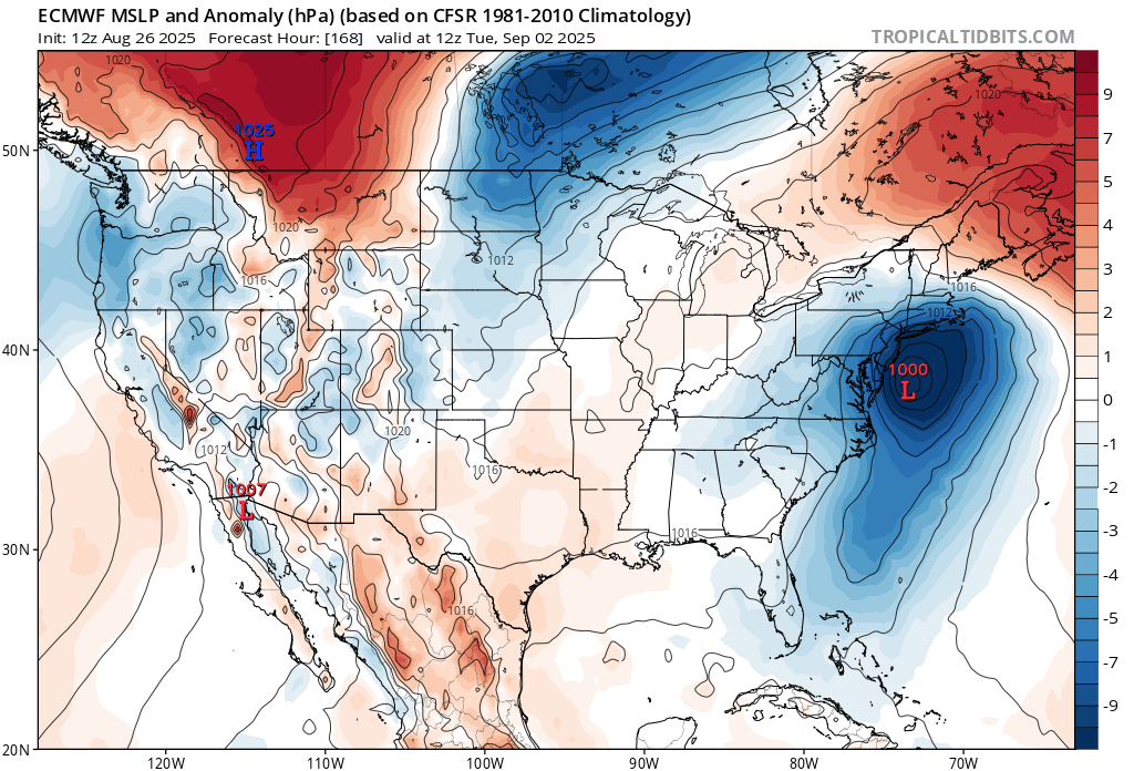
 Would be nice to ease the developing dry conditions for the OP to score a win here. But the EPS is still more suppressed. I hope they move toward the OP over the next several runs.
-
Saved by the clouds ... yesterday's high was 89.6F. Today, after an overnight low of 68F we're barely making it to only 80F.
-
2025 Atlantic Hurricane Season
BarryStantonGBP replied to BarryStantonGBP's topic in Tropical Headquarters
-

2025 Spring/Summer Mountain Thread
BlueRidgeFolklore replied to Maggie Valley Steve's topic in Southeastern States
Wait until tomorrow! -
2025 Atlantic Hurricane Season
BarryStantonGBP replied to BarryStantonGBP's topic in Tropical Headquarters
the atlantic said she'll get fookin pissed in mid September especially with that nonce humberto from the Notting Hill carnival -
-
ERIN IS CHILLING WITH US HERE IN MANNY NOW LADS


-

2025-2026 ENSO
brooklynwx99 replied to 40/70 Benchmark's topic in Weather Forecasting and Discussion
I'm a fan of the EP Nina look showing up. most seasonals keep the EP Nina into the winter, which would bode well for EC cold/snow prospects overall
-
Box not too "excited" yet...high reso-lust-ion lol We`ll have details when we enter the real of hi-resolustion guidance Wednesday night/Thursday morning.
-
@Gawx
-
 You sound like bizarro nycwinter
 -
We got an early hint how cold the 1976-1977 winter was going to be with the record cold outbreak at the end of August 1976. Data for August 31, 1976 through August 31, 1976 Click column heading to sort ascending, click again to sort descending. NY WALDEN 1 ESE COOP 37 NY PORT JERVIS COOP 38 CT DANBURY COOP 38 NJ CANOE BROOK COOP 39 NY CARMEL COOP 39 CT WESTBROOK COOP 39 CT MOUNT CARMEL COOP 39 CT STAMFORD 5 N COOP 40 NY SCARSDALE COOP 40 CT MIDDLETOWN 4 W COOP 40 NJ CHARLOTTEBURG RESERVOIR COOP 40 NJ PLAINFIELD COOP 41 CT NORWALK GAS PLANT COOP 41 NJ ESSEX FELLS SERVICE BLDG COOP 42 NY YORKTOWN HEIGHTS 1W COOP 42 NY WESTCHESTER CO AP WBAN 42 NY SUFFERN COOP 42 NY WEST POINT COOP 42 NJ TETERBORO AIRPORT WBAN 43 NY BEDFORD HILLS COOP 43 CT NEW HAVEN TWEED AP WBAN 43 CT GROTON COOP 43 NJ LITTLE FALLS COOP 44 NY MIDDLETOWN 2 NW COOP 44 NY PATCHOGUE 2 N COOP 45 NY NEW YORK BOTANICAL GARDEN COOP 45 CT NORWICH PUBLIC UTILITY PLANT COOP 45 NY NY WESTERLEIGH STAT IS COOP 46 NY MINEOLA COOP 46 NY DOBBS FERRY-ARDSLEY COOP 46 NY BRIDGEHAMPTON COOP 46 CT NEW HAVEN COOP 47 NY SETAUKET STRONG COOP 47 NJ NEWARK LIBERTY INTL AP WBAN 48 NJ MIDLAND PARK COOP 48 NJ JERSEY CITY COOP 50 NY NY CITY CENTRAL PARK WBAN 50 CT IGOR I SIKORSKY MEMORIAL AIRPORT WBAN 50 NY GREENPORT POWER HOUSE COOP 50 NY LAGUARDIA AIRPORT WBAN 52 NY JFK INTERNATIONAL AIRPORT WBAN 52 NY ISLIP-LI MACARTHUR AP WBAN 52 NY MONTAUK COOP 52 NY NEW YORK AVE V BROOKLYN COOP 53 NY NEW YORK LAUREL HILL COOP 53 NY RIVERHEAD RESEARCH FARM COOP 54 Data for August 31, 1976 through August 31, 1976 Click column heading to sort ascending, click again to sort descending. PA TOBYHANNA POCONO MOUNTAIN ARPT WBAN 34 PA BELTZVILLE DAM COOP 35 NJ INDIAN MILLS 2 W COOP 36 NJ NEWTON COOP 36 PA EAST STROUDSBURG COOP 37 NJ SUSSEX 1 NW COOP 37 NJ MORRIS PLAINS 1 W COOP 37 NJ FLEMINGTON 5 NNW COOP 38 NJ SOMERVILLE 4 NW COOP 38 PA PERKASIE COOP 39 PA PALMERTON COOP 39 NJ CHATSWORTH COOP 39 PA GEORGE SCHOOL COOP 39 MD CENTREVILLE COOP 40 NJ BELLEPLAIN STA FOREST COOP 40 NJ ATLANTIC CITY INTL AP WBAN 40 NJ PEMBERTON COOP 40 NJ ESTELL MANOR COOP 40 NJ TOMS RIVER COOP 40 PA PHOENIXVILLE 1 E COOP 41 NJ HIGHTSTOWN 2 W COOP 41 NJ LAMBERTVILLE COOP 41 NJ FREEHOLD-MARLBORO COOP 41 NJ BOONTON 1 SE COOP 41 DE GEORGETOWN 5 SW COOP 42 MD MILLINGTON 1 SE COOP 42 PA WEST CHESTER 2 NW COOP 42 PA GRATERFORD 1 E COOP 42 PA READING 4 NNW COOP 42 NJ WOODSTOWN PITTSGROV 4E COOP 42 NJ HAMMONTON 1 NE COOP 42 NJ BELVIDERE COOP 42 NJ TUCKERTON 2 NE COOP 42 NJ LAKEHURST NAS WBAN 42 DE MIDDLETOWN 3 E COOP 43 PA COATESVILLE 1 SW COOP 43 PA MORGANTOWN COOP 43 PA ALLENTOWN LEHIGH VALLEY INTERNATIONAL AIRPORT WBAN 43 NJ CHERRY HILL COOP 43 NJ LONG BRANCH-OAKHURST COOP 43 NJ NEW BRUNSWICK 3 SE COOP 43 DE MILFORD 2 SE COOP 44 NJ SEABROOK FARMS COOP 44 NJ WEST WHARTON COOP 44 MD EASTON COOP 45 DE BRIDGEVILLE 1 NW COOP 45 MD DENTON 2 E COOP 45 DE NEWARK AG FARM COOP 45 PA WEST GROVE 1 SE COOP 45 DE WILMINGTON PORTER RES COOP 46 NJ SHILOH COOP 46 NJ MILLVILLE MUNICIPAL AIRPORT WBAN 46 PA NORTHEAST PHILADELPHIA AIRPORT WBAN 46 NJ GLASSBORO 2 NE COOP 47 PA WILLOW GROVE NAS WBAN 47 MD CHESTERTOWN COOP 48 NJ AUDUBON COOP 48 NJ TRENTON WBAN 48 MD ROYAL OAK 2 SSW COOP 49 DE DOVER COOP 49 MD PRESTON 1 S COOP 49 DE WILMINGTON AIRPORT WBAN 50 PA DEVAULT 1 W COOP 50 PA NORRISTOWN COOP 50 NJ CAPE MAY 2 NW COOP 50 NJ SPLIT ROCK POND COOP 50 PA PHILADELPHIA INTL AP WBAN 51 DE LEWES COOP 53 PA DREXEL UNIV COOP 53 PA MARCUS HOOK COOP 54 PA PHILADELPHIA 23D & MARKET COOP 54 PA PHILADELPHIA WBAN 56 PA PHILADELPHIA WSFO COOP 56
-
The standards or 30 year climate normals originated back in a stable climate when there weren’t significant temperature rises with every new 10 year update. This is why your area had the warmest summer on record back in 2020 at 77.9° and the departure was only +2.9° using 1991-2020 climate normals. Under the 1951-1980 climate normals it would have been a +4.3 summer. It’s why NOAA is exploring using alternatives to the climate normals. Many organizations just set the climate normals to an earlier period before the climate began to rapidly warm so the departures more closely resemble the actual temperatures. https://yaleclimateconnections.org/2021/02/updated-yardstick-begs-question-whats-normal-in-a-changing-climate/ Time Series Summary for Middletown-Harrisburg Area, PA (ThreadEx) Top 10 warmest summers using dense rank sorting for temperature Click column heading to sort ascending, click again to sort descending. 1 2020 77.9 0 2 1966 77.6 0 3 2016 77.3 0 4 2021 77.1 0 5 2024 76.9 0 6 2010 76.8 0 7 2022 76.7 0 - 1999 76.7 0 8 2019 76.5 0 - 2005 76.5 0 9 1991 76.4 0 10 1900 76.2 0
-

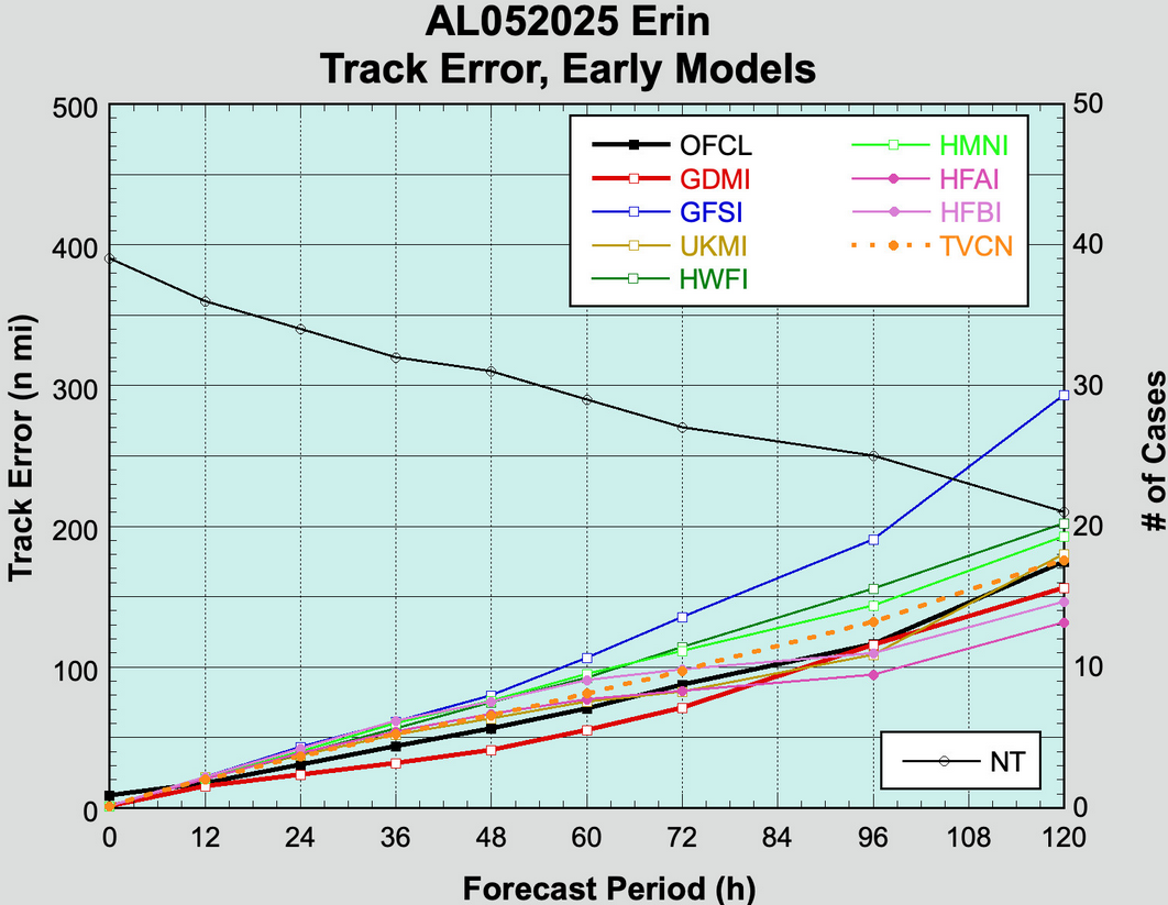
2025 Atlantic Hurricane Season
WxWatcher007 replied to BarryStantonGBP's topic in Tropical Headquarters
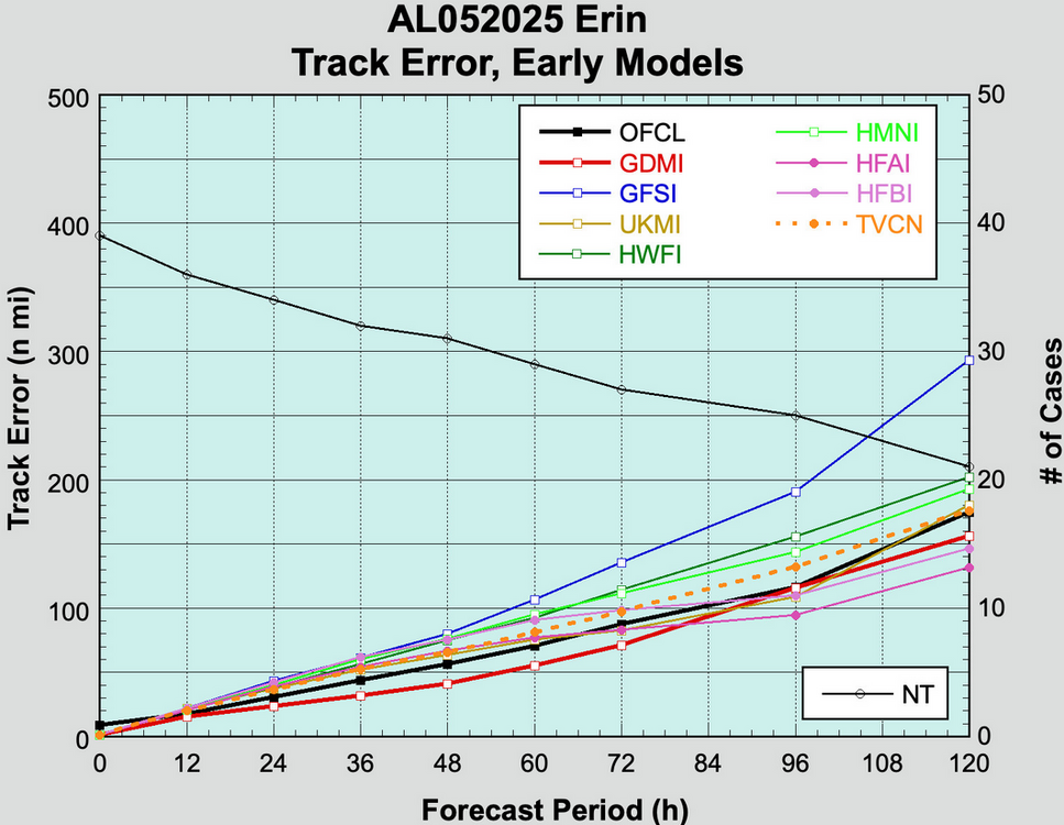
I don’t see anything possible other than homebrew/hybrid off the east coast in the next week or so. -
Had a heavy lake-effect rain shower move through late this morning. Was hoping for one rumble to make it a rare lake-effect thunderstorm but no such luck.
-
 Agreed. If you're not in the shade and there's 0 clouds anything above 70 or so feels quite hot

.thumb.jpg.ad3a2e31d30aff035044689b311a0540.jpg)


.png.f58d138b67a7dca27ccb7b28b552f37b.png)


