All Activity
- Past hour
-
Ukmet will not be as far north as its 0z run. Still ejects the SW but doesn't phase it as far back so should be better for all of us.
-

Storm potential January 17th-18th
winterwx21 replied to WeatherGeek2025's topic in New York City Metro
After getting 6 inches of snow from the three rounds this weekend, I'm up to 18.5" for the winter. We're well on our way to our first above average snowfall winter in quite awhile. -
18 degrees colder in Chattanooga at 132 compared to 6z.
-
The lighter ICON is worse to me..lighter precipitation plus colder surface...easier for to accumulate on powerlines.
-
for such little snow their is a ridiculous amount of salt on the sidewalks and the street every time a big truck goes on by a mist of salt follows..
-

Winter 2025-26 Medium/Long Range Discussion
Chicago Storm replied to michsnowfreak's topic in Lakes/Ohio Valley
the GEM (and RGEM to an extent) over-do cold temperatures, sometimes significantly so. -
Obviously that's extreme lol but feast/famine or storms in bunches has historically how we roll in the MA. We're conditioned to expect fail (especially the last 10 years or so) but we also haven't had a blocked pattern like this since 2011. I'm personally expecting a second legit threat at least over the next 2 weeks. Blocking cycles like this have historically lasted 30-45 days. Imo, it would be much less likely for things to fall apart quickly than hang around and deliver. I had a hunch this winter would be blocky and so far it has been pretty good in that department. The upcoming period looks ideal. Just need things to remain active to capitalize. That piece is always random and chaotic but give us enough chances and we'll do just fine imo.
-
Ukmet ejecting wave like cmc. Let’s see where it goes.
-
Is there a Weenie Rule that these storms tend to get juicer QPF as we get closer to the event... If we can hold and get into NAM range it might get ridic
-
Low key had a lot of 1995 analogs pop when I did my seasonal for the office this winter. It was strong enough that I've got a wager going for a 20+" seasonal here. Doesn't mean we're getting the nutty 50+ that season had, but not at all surprising that this stuff is starting to pop off now that WPac warm pool forcing is strengthening and Nina forcing is waning.
-
No way dude, you could literally be across the street from me for all i know!
-

January 2026 Medium/Long Range Discussion
NorthArlington101 replied to snowfan's topic in Mid Atlantic
Also the NBM is… well, folks-y. 9” mean for DC. -
Side note: the aurora may be visible on the horizon tonight. NOAA SWPC has a G4 Watch for tonight-tomorrow AM. New moon and clear sky should offer a good viewing opportunity if you're willing to find a dark sky and freeze outside.
-
Oh dang. The 12z AIGFS did correct southward by quite a bit.
-

Winter 2025-26 Medium/Long Range Discussion
A-L-E-K replied to michsnowfreak's topic in Lakes/Ohio Valley
let's ride it -
Don’t have to imagine we have had it before.
-
This as well. This isn’t my bias but an absolute fact that deterministic models at range never account for CAD correctly. I’d expect we’ll see it under modeled until that Wed/ thurs window.
-
January 2026 Medium/Long Range Discussion
NorthArlington101 replied to snowfan's topic in Mid Atlantic
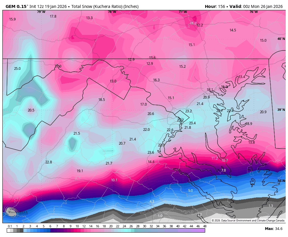
CMC in hi-rez
-
Listen I will happily risk amped over suppression any day...keep that ampin' and rampin'!
-
Lame, we got 60" in a 12 day period in 2010.
-

MO/KS/AR/OK 2025-2026 Winter Discussion
StormChazer replied to stormdragonwx's topic in Central/Western States
Typical Canadian run of it trying to layout unrealistic scenarios. BUT, it is a major improvement over last night's run. + Meanwhile the 12zGFS scales back and keeps most of the moisture to the south. -
GEFS looks like it should be improved to some extent
-
Leave it to Ji to bring us back down lol
-
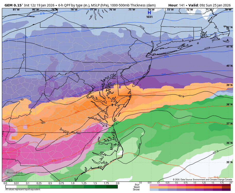
See 12z for MBY went about way would expect lol...ice. Scary part is the GFS AI corrected course until it cropped out on pivotal. Last frame matches CMC pretty close
-
lol at the CMC. imagine getting 2' of snow in the fuckin teens. lol


.thumb.jpeg.f5c6ba9d911ec96b3b124f8606aee58e.jpeg)