All Activity
- Past hour
-
-
 Locked in for the winds. Tornados are the wild card
 -
 And they were just "enhanced"
 -
 And temps higher than the low 60s
 -
Simple-Erring on the side of caution.
-
 For these parts, a pretty good severe setup. I lived in Midland, TX for 5 years, so this is relatively ho-hum. Wake me up where there are 60k ft topped super cells with baseball+ sized hail and naders
- 193 replies
-
- 3
-

-

-
- severe
- thunderstorms
- (and 1 more)
-
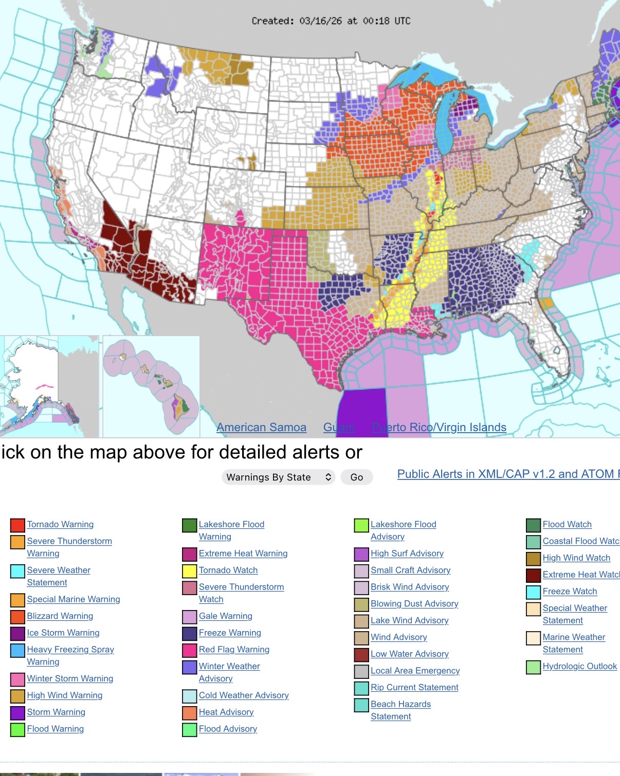
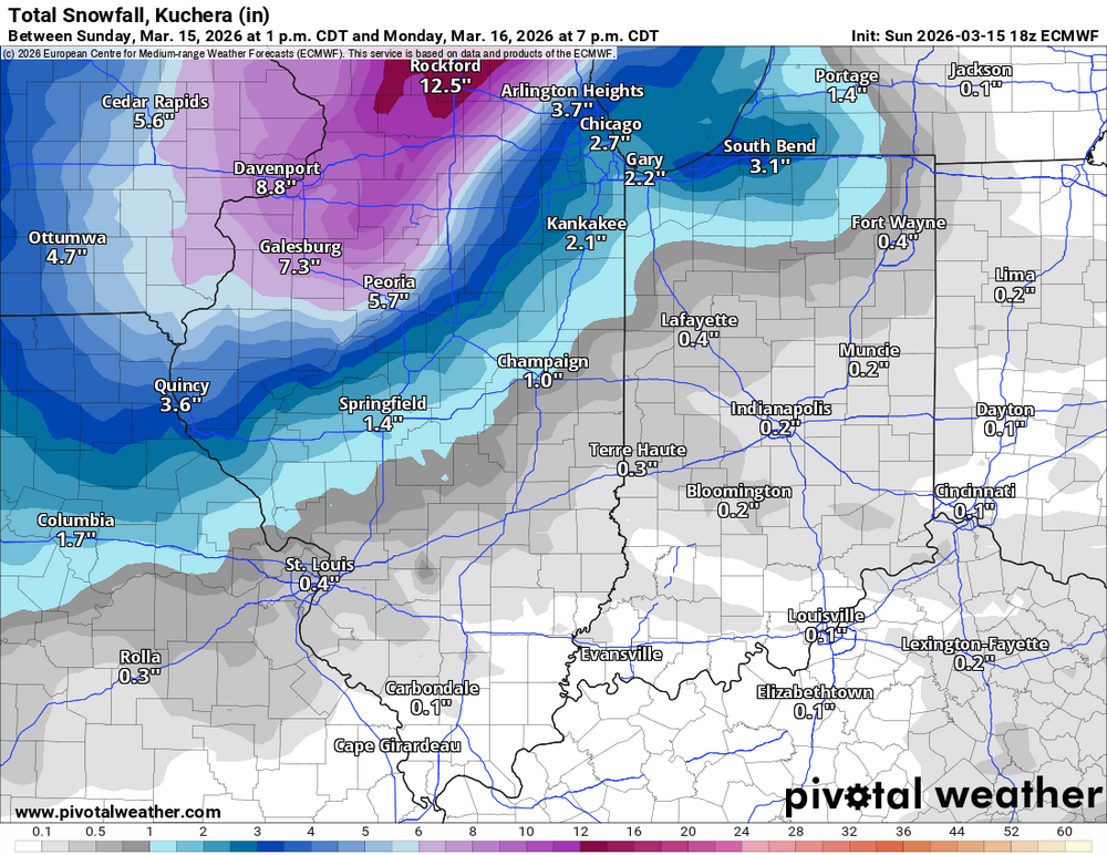
chicago update We just recently updated the forecast to upgrade our Winter Storm Warning to a Blizzard Warning. We also included Dekalb and McHenry counties in this warning. We also expanded the Winter Weather advisory anther row of counties southeastward along the I-55 corridor. The storm system is tracking farther south then originally thought. Overall, this adds concern that snowfall amounts may end up a bit higher than previous forecasts, particularly across the warned area where several hours of wind gusts of 45 to 50 mph will combine with the snow overnight into Monday morning to produce blizzard conditions. With this in mind, and the fact that there are numerous upstream obs across IA and parts of MO that are reporting 1/4 or less VSBYs, felt the path of least regret was to pull the trigger on the upgrade.
-
.thumb.jpg.6a4895b2a43f87359e4e7d04a6fa0d14.jpg)
Central PA Spring 2026 Discussion/Obs Thread
Yardstickgozinya replied to Voyager's topic in Upstate New York/Pennsylvania
Just observing where things we're heading. -
I think getting off for a thunderstorm is a little ridiculous, temps will be what low 60s? But kids probably go to school too much anyways.
-
10:1, so bump it up to whatever you're thinking is for LSRs.
-
Central PA Spring 2026 Discussion/Obs Thread
Yardstickgozinya replied to Voyager's topic in Upstate New York/Pennsylvania
Hopefully nothing now. -
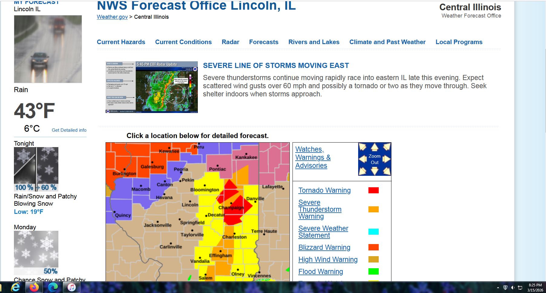
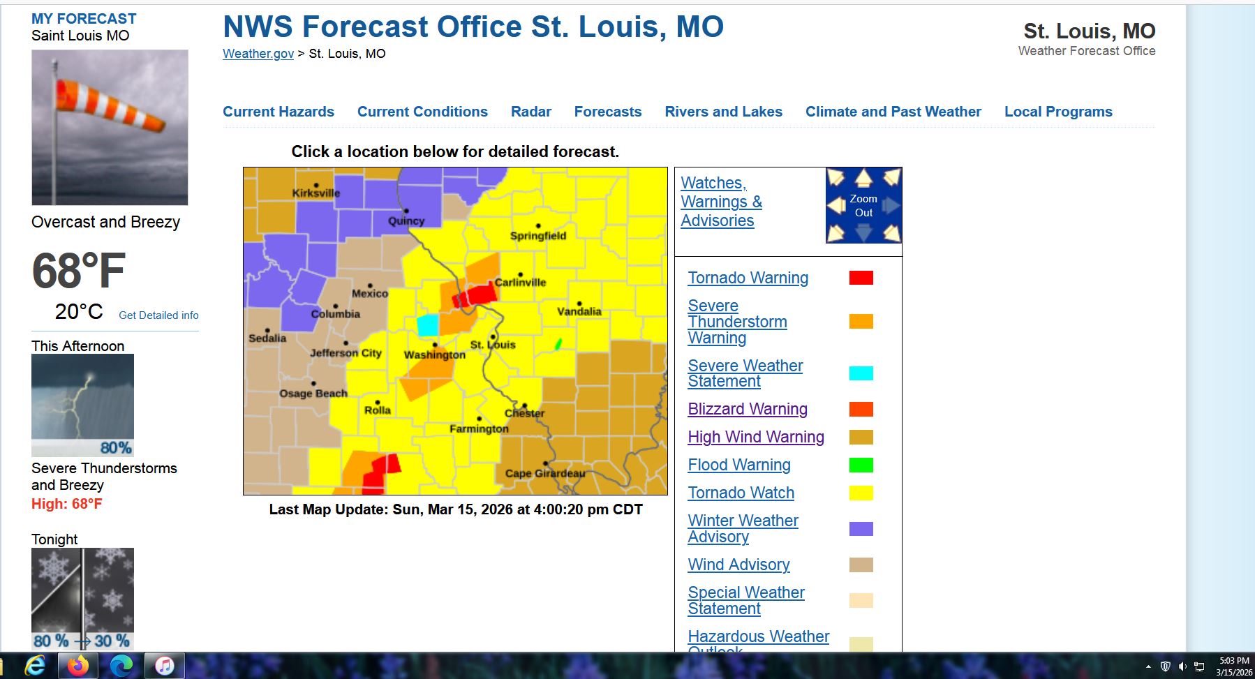
Boring here, but not in the midwest. How about a Tornado Warning and a Blizzard Warning only 70 miles apart ! And the same thing in St. Louis's market earlier today, too.


-
Show please?
-

Central PA Spring 2026 Discussion/Obs Thread
WmsptWx replied to Voyager's topic in Upstate New York/Pennsylvania
What is going on? -
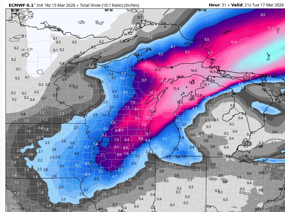
Nowcast time but 18z Euro was pretty juicy for northern IL.
-
 Hoco 3 hour dismissal tomorrow.
 -
 Latest tornado watch issued for KY and IN https://www.spc.noaa.gov/products/watch/ww0058.html URGENT - IMMEDIATE BROADCAST REQUESTED Tornado Watch Number 58 NWS Storm Prediction Center Norman OK 825 PM EDT Sun Mar 15 2026 The NWS Storm Prediction Center has issued a * Tornado Watch for portions of Central and Southern Indiana Central and Northern Kentucky * Effective this Sunday night and Monday morning from 825 PM until 300 AM EDT. * Primary threats include... A couple tornadoes possible Widespread damaging winds and isolated significant gusts to 80 mph likely SUMMARY...A severe squall line is forecast to rapidly move east-northeast across the Watch area this evening into tonight. Damaging gusts will likely be the most prevalent hazard, but a couple of tornadoes are also possible with embedded mesovortices within the squall line.
 -
Milwaukee has officially put a blizzard warning now. First one since 12/20/12 here.
-
You're not even technically in this geographical forum. Why do you always speak as if you speak for the entire population of the forum when at best you're the southern extreme.
-
 Schools are calling it for tomorrow. Chesterfield is out
 -
Central PA Spring 2026 Discussion/Obs Thread
Yardstickgozinya replied to Voyager's topic in Upstate New York/Pennsylvania
Everybody in this forum's compassionate person. Nobody wants to see anybody get hurt and not one single gripe. Orbit of excitement is going to change any of it g******** -
Top 3 event for you already!