All Activity
- Past hour
-
Looks like a chance at tumble weeds on the gfs. A real snooze fest lol
-
Meh lol. I may need to get a real snowstorm out of my system before I get interested in these nickel and dime frozen events again, unless it’s a legit ice storm (those can be cool minus the power outages). Driving in any sort of ice sucks, though, so from an actual weather forecaster perspective it should be taken seriously due to travel impacts.
-

Snow Potential Dec 26-27
coastalplainsnowman replied to WeatherGeek2025's topic in New York City Metro
must....resist....Michael....Scott....joke..... -

Central PA Winter 25/26 Discussion and Obs
Ruin replied to MAG5035's topic in Upstate New York/Pennsylvania
Looks very dry im glad I didn't want a ice storm -
If you were to pick a best place to be for this storm it’s probably the eastern Catskills to Albany then SE from there through most of CT. If you get 10” anywhere that’s where it’d probably be. Huge start to the season for S NY to the Capital district. I’m honestly more concerned about the big overrunning going to my north and getting porked on QPF waiting in subsidence vs a period of sleet that would cut my totals down but we’ll see. Odds are still for a significant event here east of the city for most of LI.
-
Sleet here in Dulles.
-
Another issue is that the airmass is really dry. We’re going to need to see some good dynamics to overcome it.
-

26th-27th event, coming at us like a wounded duck.
bristolri_wx replied to Go Kart Mozart's topic in New England
-

26th-27th event, coming at us like a wounded duck.
TalcottWx replied to Go Kart Mozart's topic in New England
I think we're in a great spot. The lack of a WSW for Hartford County is puzzling. -

26th-27th event, coming at us like a wounded duck.
40/70 Benchmark replied to Go Kart Mozart's topic in New England
Final https://easternmassweather.blogspot.com/2025/12/final-call-for-saturday-snows.html -
Idk. I always thought we wanted lower heights a lil north of Hawaii for us to benefit here in east usa
-
26th-27th event, coming at us like a wounded duck.
TalcottWx replied to Go Kart Mozart's topic in New England
It's my town limits, hehe -

26th-27th event, coming at us like a wounded duck.
WinterWolf replied to Go Kart Mozart's topic in New England
Southington too…don’t leave us out. -

26th-27th event, coming at us like a wounded duck.
Fozz replied to Go Kart Mozart's topic in New England
It’s not a screw job if there’s less to your east. 2” > a mere coating -
Winter 2025-2026 Offers Return to Normalcy
40/70 Benchmark replied to 40/70 Benchmark's topic in New England
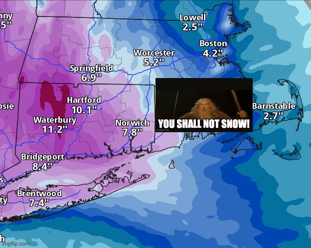
Final Call For Saturday Snows More Significant Impact Region-wide Synoptic Overview There have been subtle changes from First Call issued on Monday that will have fairly significant impacts across the region. The general evolution remains the same, as the northern steam disturbance approaching from the west will encounter confluence over northern New England and weaken while being deflected to the southeast. However, it now appears that said confluence will be slightly weaker and further to the northeast, meaning that the approaching system makes it slightly further north and remains coherent enough for sizable impacts into the region. Note that by 4pm this afternoon, the system has closed over the eastern Great Lakes. After midnight, the mid level low makes it into New York State, at which point it begins to encounter the confluence from the block to the north east, and in response weakens and veers more to the southeast. Expected Storm Evolution Snowfall should begin to break out across southwestern Connecticut this evening. Overspreading central Massachusetts by midnight. And the balance of southern New England by shortly thereafter, although it may struggle to reach the ground initially due to the antecedent dry air. During the predawn hours, a heavy burst of snow moving northeast in association with the 700mb warm front will begin to slow over Connecticut river valley of Massachusetts into the far northeastern corner of Connecticut, as the warm push aloft meets resistance from the confluence stationed over Maine. This will prolong a few hour stretch of up to 1-2"/hr snowfall rates in this area. It is at this point that the system will begin to weaken, and the dynamics will before more diffuse as the storm progresses eastward. It is at this point by mid morning that the focus of the storm will shift to the north and south shore of the Boston area, as ocean effect and enhanced snow becomes the predominate low level forcing mechanism as the mid level dynamics decay. Snowfall will taper off across the region of the region during midday hours. and ultimately during the afternoon across the north and south shore. FINAL CALL: -
These types of events are more typical of Chicago and the plains than us. That’s why they are so much more prone to ice storms than we are. PA might get significant ice.
-
We've heard that before.. and well it's the JMA so.. lol
-

26th-27th event, coming at us like a wounded duck.
HoarfrostHubb replied to Go Kart Mozart's topic in New England
Nobody knows where any of those "towns" are... -
15z HRRR continues to show the best snows north of NJ-NY border and it keeps gradually pushing the low/mid-level lows further northeast before redeveloping south. More and more mix and dry slot into the BGM area... I really hope it's wrong... but that's why we have the hourly guidance.
-
26th-27th event, coming at us like a wounded duck.
TalcottWx replied to Go Kart Mozart's topic in New England
West Simsbury-Weatogue-Tariffville. -
The majority of the snow will fall in a 2-4 hour window. That’s always been the case. Light snow should persist in some areas until around sunrise if the inverted trough sets up.
-
It won't even be that, it'll be 4 hours from like 7-11pm. I think after that its just snizzle/pellets/frz drizzle, even in SW CT and the LHV where they may get 7-10 inches that'll happen. Its rare to see big overrunning type events be snow all the way through, even in areas which get hit hard
-
Grocery stores are going to be at a peak right now. 1. Most people shop on Friday. 2. It’s right after Christmas so everybody’s stocking up. 3. And an impending winter storm
-

26th-27th event, coming at us like a wounded duck.
weatherwiz replied to Go Kart Mozart's topic in New England
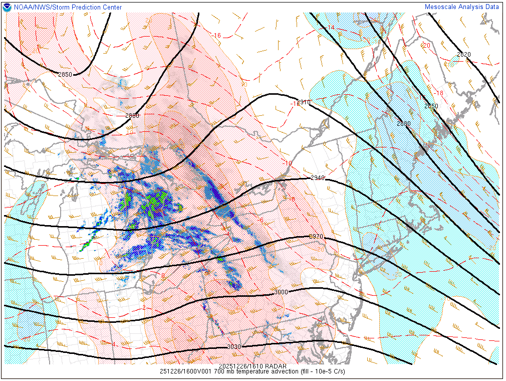
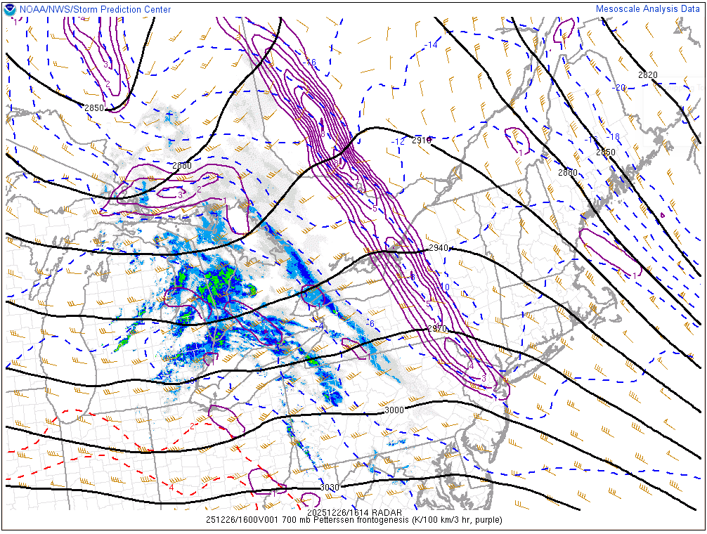
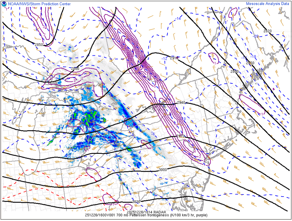
Not sure if this means much but I don't think the dewpoints were as low as modeled, we still have quite the dewpoint depression but maybe this will help to saturate more quickly? But we can already start watching everything evolve in real time. Pretty strong surge of WAA at 700mb just to our west and we have our established zone of 700mb fronto Two things we're going to want to watch through the afternoon are 1. How strong does the WAA remain 2. How quickly/when does it begin to weaken? But this look right now is certainly promising for western areas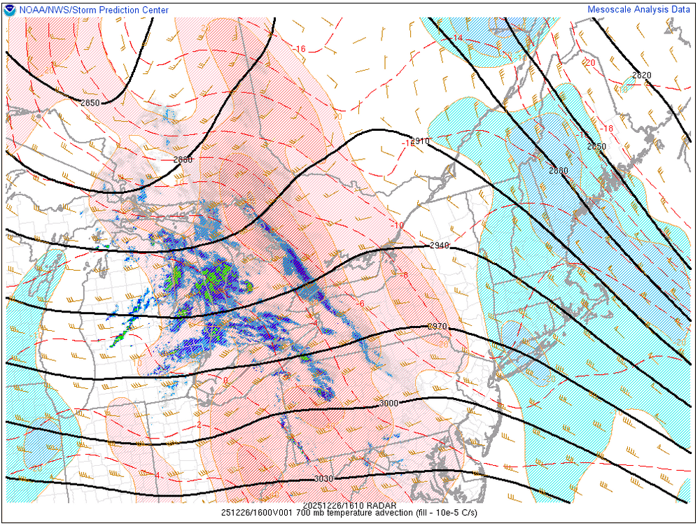
-
32.7 F here so far not much going on