All Activity
- Past hour
-

2025-2026 ENSO
donsutherland1 replied to 40/70 Benchmark's topic in Weather Forecasting and Discussion
I agree. Hopefully, CPC will start using RONI as its official measure. In any case, the relationship holds true with ONI or RONI. -
Records: Highs: EWR: 74 (1931) NYC: 73 (1931) LGA: 70 (1964) JFK: 71 (1964) Lows: EWR: 22 (2019) NYC: 23 (2019) LGA: 24 (2019) JFK: 23 (2019) Historical: 1833: In 1833, observers were familiar with the Leonid meteor shower, but the event that year was very intense and leads to the first formulation of a theory on the origin of meteors. By some estimates, the 1833 Leonid meteor shower had 240,000 meteors in a nine-hour period. 1879: Nov. heat wave hits DC with second latest 80° reading ever to this date. (Ref. Washington Weather Records - KDCA) 1881: Hailstones from a tremendous storm that hit Georgia on the 8th were still visible nearly a week later at Dry Pond, GA. (Ref. AccWeather Weather History) 1904: This hurricane moved north to near Cape Hatteras. As the system became nontropical, cold air on the west side of the circulation set up an early snowstorm across North Carolina. A twenty-four hour rainfall record was set for November at Farmville (3.17"). Richmond, VA had 1.65 inches precipitation and 1.8 inches of snow from this storm. A Late East Coast Storms (Ref. Richmond Weather Records.) 1933 - The first dust storm of the great dust bowl era of the 1930s occurred. The dust storm, which had spread from Montana to the Ohio Valley the day before, prevailed from Georgia to Maine resulting in a black rain over New York and a brown snow in Vermont. Parts of South Dakota, Minnesota and Iowa reported zero visibility on the 12th. On the 13th, dust reduced the visibility to half a mile in Tennessee. (David Ludlum) (The Weather Channel) 1938: Snowstorm across Northern Minnesota. Barometer falls to 29.31 in Duluth,MN. (Ref. AccWeather Weather History) 1946 - General Electric scientists produced snow in the Massachusetts Berkshires in the first modern day cloud seeding experiment. (The Weather Channel) 1946: General Electric scientists produced snow in the Massachusetts Berkshires in the first modern-day cloud seeding experiment. Scientist Vincent Schaefer dropped six pounds of dry ice pellets into a cloud over Pittsfield, MA. The cloud seeding experiment produced snowfall, as a 4-mile long cloud was converted into snow flurries. The success of the experiment became the basis of many weather modification projects. 1953 - Strong southeasterly winds associated with a Pacific cold front reached 70 mph at Sacramento CA to equal their all-time record. The previous record had been established in a similar weather pattern on December 12th of the previous year. (The Weather Channel) 1981 - A powerful cyclone brought high winds to Washington State and Oregon. The cyclone, which formed about 1000 miles west of San Francisco, intensified rapidly as it approached the Oregon coast with the central pressure reaching 28.22 inches (956 millibars). A wind trace from the Whiskey Run Turbine Site, about 12 miles south of Coos Bay in Oregon, showed peak gusts to 97 mph fifty feet above ground level. The wind caused widespread damage in Washington and Oregon, with 12 deaths reported. As much as four feet of snow fell in the Sierra Nevada Range of northern California. (Storm Data) 1986: High temperatures are held in the upper teens to lower 20s as arctic air pours into Lower Michigan. The high of 19° at Grand Rapids, MI is a record for the date and the coldest high temperature for so early in the season. Widespread record lows were set from the Plains to the Southeast including: International Falls, MN: -12°, Duluth, MN: -7°, North Platte, NE: -7°, Marquette, MI: -5°, Sioux City, IA: -4°, Rochester, MN: -4°, Omaha, NE: -2°, Waterloo, IA: -1°, Minneapolis, MN: 0°, Dubuque, IA: 1°, Green Bay, WI: 2°, La Crosse, WI: 2°, Madison, WI: 2°, Concordia, KS: 2°, Kansas City, MO: 3°, Rockford, IL: 3°, Ste. St. Marie, MI: 4°, Topeka, KS: 4°, Springfield, MO: 5°, Milwaukee, WI: 5°, Moline, IL: 5°, Chicago, IL: 6°, Columbia, MO: 7°, Springfield, IL: 7°, St. Louis, MO: 10°, Indianapolis, IN: 10°, Grand Rapids, MI: 10°, Paducah, KY: 10° (broke previous record by 10 degrees), Beckley, WV: 12°, Dayton, OH: 13°, Bristol, TN: 19°. (Ref. Wilson Wx. History) 1987 - A storm moving off the Pacific Ocean produced rain and gale force winds along the northern and central Pacific coast, and heavy snow in the Cascade Mountains. Cold weather prevailed in the southeastern U.S. Five cities reported record low temperatures for the date, including Asheville NC with a reading of 21 degrees. (The National Weather Summary) (Storm Data) 1988 - Low pressure brought rain and snow and gusty winds to the northeastern U.S. A thunderstorm drenched Agawam MA with 1.25 inches of rain in fifteen minutes. Winds gusted to 58 mph at Nantucket MA. (The National Weather Summary) (Storm Data) 1989 - Thirty-two cities in the central and eastern U.S. reported record high temperatures for the date as readings warmed into the 70s as far north as Michigan and Pennsylvania. Afternoon highs in the 80s were reported from the Southern Plains to the southern Atlantic coast. Columbia SC reported a record high of 86 degrees, and the high of 71 degrees at Flint MI was their warmest of record for so late in the season. (The National Weather Summary) 1999: Over 135 daily record highs were established across the western and central United States as an unseasonable 588 decameter heat ridge dominated. Lincoln and Omaha, NE set their all-time November high temperature records with 85° and 83° respectively. Lincoln broke their previous record by 11 degrees. Springfield, MO tied their all-time November record with 81° as did Idyllwild, CA with 80°. (Ref. AccWeather Weather History)
-
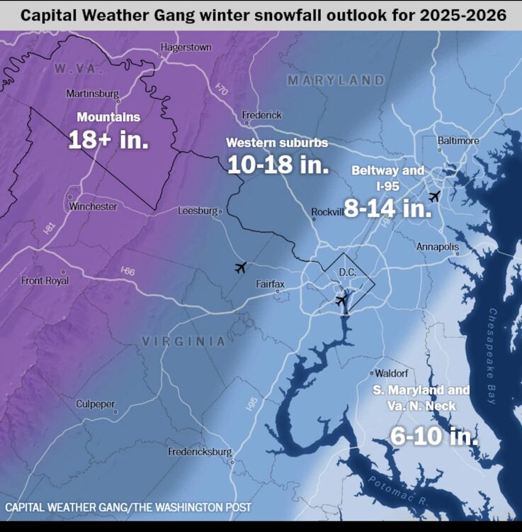
WP forecast is for slightly below average snowfall and the article is a good reference because it provides a summary/link of the local forecaster's winter forecasts. General theme is more snow for the NW zones this year. https://www.washingtonpost.com/weather/2025/11/13/dc-winter-forecast-snow-2025-2026/
-
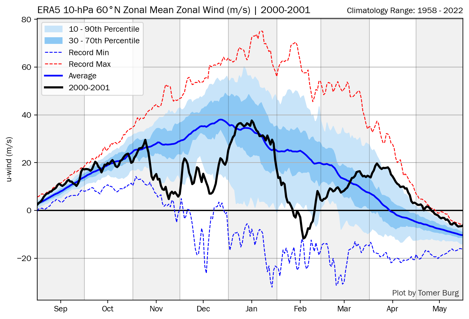
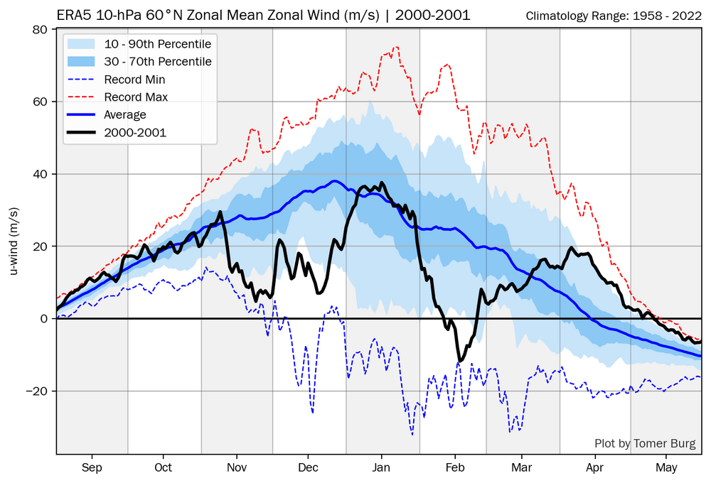
There are no official Nov or Dec major SSWs based on reversals at 10 mb for any of 1983, 1989, and 2000. To be fair if you read this closely, BAMwx isn’t explicitly saying that there was an early major SSW in any of those 3 years (if they were they’d be wrong): A few of these years were absolutely blockbuster in December. Chances to replicate the intensity of cold in years like 2000, 1989 and 1983 are unlikely, but there is strong support notable cold the first half of December setting up. That’s not to say that the SPV wasn’t weak. Despite no reversal, 2000 was quite weak mid-Nov through Dec with a low of +4 to +5 m/s in late Nov as per the chart below: (I don’t have these charts for 1983 and 1989….does anyone else have a link to them?):
-
48 / 34 clouds moved in. Perhaps some breaks in the clouds as winds pick up today and get gusty this afternoon and evening. Warmer Fri - Sun with clouds lingering through Saturday, may finally see a sunny day return Sunday. back and forth cooler Mon / Tue before moderating back to and / above normal. Euro with a pronounced strong ridge into the east towards the week 22nd with a warmer week. Beyond there could be back down to close the month and open next.
-

2025-2026 ENSO
40/70 Benchmark replied to 40/70 Benchmark's topic in Weather Forecasting and Discussion
Last year was close...I ultimately deemed it moderate after considering MEI and ONI. -
2025-2026 ENSO
donsutherland1 replied to 40/70 Benchmark's topic in Weather Forecasting and Discussion
For another illustration of the importance of the PNA for parts of the East, the EPS is forecasting a WPO-/EPO-/AO-/PNA- pattern for the first 10 days of December. Setting aside skill issue at that range, here's how things have fared 1980-2024 when the only difference was a PNA- vs. a PNA+. I used NYC, but the same applies broadly to the Middle Atlantic Region.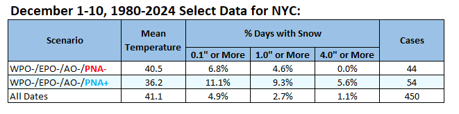
-
2025-2026 ENSO
40/70 Benchmark replied to 40/70 Benchmark's topic in Weather Forecasting and Discussion
They always get blown out of proportion. Indicative of the decay of society....increased proclivity towards instant gratification and shorter attention spans, decreased tendency towards delayed gratification and the ability to think critically. I would still bet against an actual reversal of the mean zonal wind. -
CC: @WxUSAF
-

Occasional Thoughts on Climate Change
Typhoon Tip replied to donsutherland1's topic in Climate Change
You're both right... The biggest problem in humanity isn't technology. The technology is within reach. There needs to be a motivating "response mechanism." Unfortunately, CC is too silent, too invisible to the everyday experience - really is a biological limitation. Changes in attitude comes from an instilling sense of urgency ... that is what is needed. CC necessarily must become the metaphoric gun pressed up against the humanity temple. That's what will motivate the true and ubiquitous revolution toward green technologies. There are those already proven by physics to be plausible, if not demonstrated to work in the lab. The technology exists within reach. Humans won't sense that urgency until they see death and feel pain. It's that simple. We right these diatribes but we're just ping ponging the same message back and forth, semantically redrawn but the picture doesn't change. My personal position on this is that the campaign needs to be less like a campaign, and more like strategy to get humanity connected with the perils of CC in a personal scary way. -

November 2025 general discussions and probable topic derailings ...
dendrite replied to Typhoon Tip's topic in New England

-

November 2025 general discussions and probable topic derailings ...
CoastalWx replied to Typhoon Tip's topic in New England
6z euro AI is sort of what I was hoping to see for any wintry chance in SNE. Temps are borderline, but that’s how you would do it. Day 9-10 so you know the rules….but just pointing out the setup. -
Chinas development of renewable energy is built on coal. A true energy revolution there would replace coal and not just use renewables as an addition. The reason that fossil fuels are lingering is that the current renewables don’t have to capacity to lead to a true revolution away from fossil fuels yet. For now, the world isn’t performing an energy transition but an energy addition, where renewables top up oil, gas and coal. Regardless of well-intended green aspirations, that will remain the case for years, if not decades, unless governments impose significant changes. https://www.smh.com.au/business/markets/the-end-of-fossil-fuel-era-it-s-nowhere-near-20250911-p5mudo.html
-
I took BAMWX’s word for it. Lol I guess they are mistaken?
-
Snowman, I don’t see an SSWE at any point in Nov or Dec of 1989. Where are you seeing that? https://www.researchgate.net/figure/The-SSW-and-SFW-event-onset-date-year-and-type-identified-in-the-NCEP-NCAR-dataset-The_tbl1_267063738
-
I don't think the problem is technology. Solar has outperformed expectations for decades. Same for batteries. China has shown that solar can be deployed much faster than any competing energy technology. We could easily match as our solar resource is better than China's. No its the power of the incumbent, misinformation/denial, lack of vision, and geopolitics and others, that are allowing fossil-fuels to linger. https://x.com/JessePeltan/status/1988427201772245459
-
This has nothing to do with radiational cooling since the core of the cold also missed the interior cold spots that have no trouble radiating like HPN up in Westchester and other surrounding more rural sites. Past instances with Arctic outbreaks this intense in the Southeast were much colder across the entire Northeast. Plus they often were often of a longer duration without such a quick rebound after just one cold morning. It’s just another version of the core of the cold missing the Northeast like we have been seeing in recent years. Last January was a more recent example with the coldest departures missing the Northeast with spots that have no trouble radiating like Caribou remaining much warmer relative to areas further south.
-
I’ve been flying to the southeast since 2004 out of one of our garbage airports in NY haha. At the beginning of the season, and I’m talking around now, it is not unusual for you to fly to a place like Raleigh or Charlotte or Atlanta and have it be colder at 7 AM than LaGuardia Those places excel at radiating on clear calm nights. Even JAX, being surrounded by endless Pine Barrens is good at it. NYC is not good at radiating. Its a mess of cement, it is near the coast, it almost always has a wind component. So it is not surprising with the cold core going southeast, coupled with a clear calm night that it would be cooler there than here
-
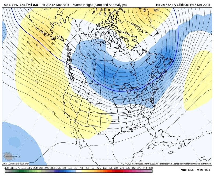
GFS and Euro ensembles overnight are showing the goods in the long range. Sent from my SM-G998U using Tapatalk

- Today
-

November 2025 general discussions and probable topic derailings ...
alex replied to Typhoon Tip's topic in New England
2” overnight but still 5 at the stake -
We need to develop a clean technology that can scale up quickly enough and at a low enough cost to actually lead to declining emissions over time. So far solar and wind are just able to supplement fossil fuels and not replace them. The renewables are being used for energy addition rather than transition. The one piece of good news in this new IEA report is that oil demand would probably increase much more than only 13% without the deployment of renewables between now and 2050. it’s quite possible that the specific energy source and method which will completely replace fossil fuels still hasn’t been developed yet in a scalable form.
-
Thanks, @John1122. Great stuff. And JP Estrella looked good last night!
-
All three 0z global ensembles show the transition to an EPO and/or PNA ridge by very late this month. Operationals don't have it at 0z, but that could easily change. Ensembles are the choice for now. Hopefully, we see further runs over the next 2-3 days which sporadically show major cold out breaks at least heading SE out of Canada along with big highs.
-
extended looking wet and cutter heavy given the stickiness of patterns and storm tracks over the past few years, i'm gonna take this as a good sign with snow climo about to rapidly improve here over the coming weeks
-

November 2025 general discussions and probable topic derailings ...
Hoth replied to Typhoon Tip's topic in New England
I was extremely saddened to hear of his passing. I have fond memories of Christmas parties with him and Nancy Aborn when I was a kid. Nice guy.