All Activity
- Past hour
-
Based off the 12z Euro and 18z GFS, it would not surprise me to see Mt. Holly hoist a watch for their zones on Maryland's eastern shore into Delaware and S. Jersey.
-

December 14th - Snow showers or Plowable snow?
SouthCoastMA replied to Sey-Mour Snow's topic in New England
looks closer to euro now, maybe a hair worse. wish we could buy another tick or two with that stuff just off shore -
Gfs is nice man. I think the spot to be for this one is Wilmington to south Jersey.
-

December 14th - Snow showers or Plowable snow?
CoastalWx replied to Sey-Mour Snow's topic in New England
Gfs definitely better. Decent event s coast. -
Maybe I’ll eek out that inch after all.
-

12/14: Sunday funday? Will the south win again?
Winter Wizard replied to TSSN+'s topic in Mid Atlantic
For reference my hometown of Wilmington, DE hasn’t seen a 6” snowfall since March 2018 while I’m pretty sure almost everyone else on this forum and northward has. Unfathomably bad luck. -
I'll take my 1-2" and call it a day from the 18z GFS
-
 Its always the youngest. The great Kahali
 -

12/14: Sunday funday? Will the south win again?
NorthArlington101 replied to TSSN+'s topic in Mid Atlantic
-
Seems the "death band" is a bit earlier... now more around 09z
-
Ya spreads more NW. finally in some accumulation on the gfs here. Keep it coming.
-

December 14th - Snow showers or Plowable snow?
weathafella replied to Sey-Mour Snow's topic in New England
Gfs looks decent to me -
12/14: Sunday funday? Will the south win again?
NorthArlington101 replied to TSSN+'s topic in Mid Atlantic
GFS a teeny bit more NE but really just noise. Still fine around DC. Best stuff definitely NE MD plummeled -
December 14th - Snow showers or Plowable snow?
SouthCoastMA replied to Sey-Mour Snow's topic in New England
GFS should be an improvement over 12z -
December 14th - Snow showers or Plowable snow?
weathafella replied to Sey-Mour Snow's topic in New England
You don’t look it! -
The RGEM would certainly make more people happy, but it doesnt really fit the specific features driving this event- it simply looks like the more impressive precip(snow) will fall in a relatively localized area. Hard to envision 4" in Frederick to N central Carroll Co AND 4-5" from N DE to Philly into in SNJ.
-
Yes. We've had it bad in this subforum, but the eastern shore and south jersey has effectively been on weenie suicide warning for almost a decade.
-
In my sig (TH 7NW hasn't updated yet. Observer sends in every 2 weeks or so)
-

Saturday night/Sunday 12/13-12/14 Jawn
kickingupastorm replied to Ralph Wiggum's topic in Philadelphia Region
Can you please post the map? -
It’s been reliably the most robust of the guidance for this upcoming event. Really living up to its predecessor.
-

12/14: Sunday funday? Will the south win again?
Maestrobjwa replied to TSSN+'s topic in Mid Atlantic
Yeah it has been a historical shaft to say the least! Would be so good to get this one -
I hope the broader Baltimore crew hits on this one. 4 plus inches. They're due
-
Hasn't that area been constantly shafted the last several years even though we had good snows the last couple of winters? I'm rooting hard for you folks up there!
-

December 14th - Snow showers or Plowable snow?
weatherwiz replied to Sey-Mour Snow's topic in New England
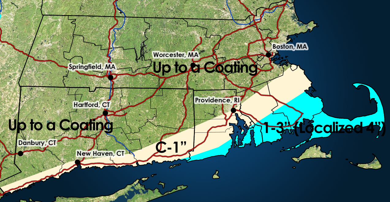
Figured why not. Anyways, unless you're close to the llvl fronto, I don't see much in the way to assist with QPF blossoming moving poleward from the developing llvl fronto band. As was stated, there could be some dry air concerns on the northern fringes of the precipitation shield and with some strengthening evidence for a more pronounced llvl fronto band, I do think there could be some room for subsidence skunking. I could see 3-5" across Long Island and probably some amounts in that range too possibly along the south coast. It's really the south coast at this point which has room for anything exceeding 2". Where stronger lift can occur will benefit from the ratios. But overall I see a pretty bland looking precipitation area outside of right where the llvl fronto is
-

Minor snow possible sunday 12/14/25
coastalplainsnowman replied to WeatherGeek2025's topic in New York City Metro
Orzo it seems.