All Activity
- Past hour
-
Very sorry JM.
-
.thumb.png.f43a9b0576a60d7be56a3d5aa5f889c6.png)
-
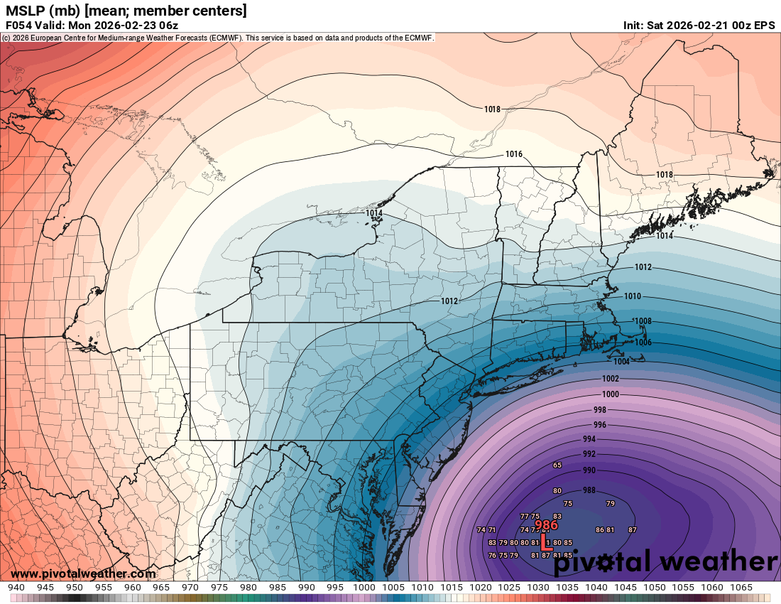
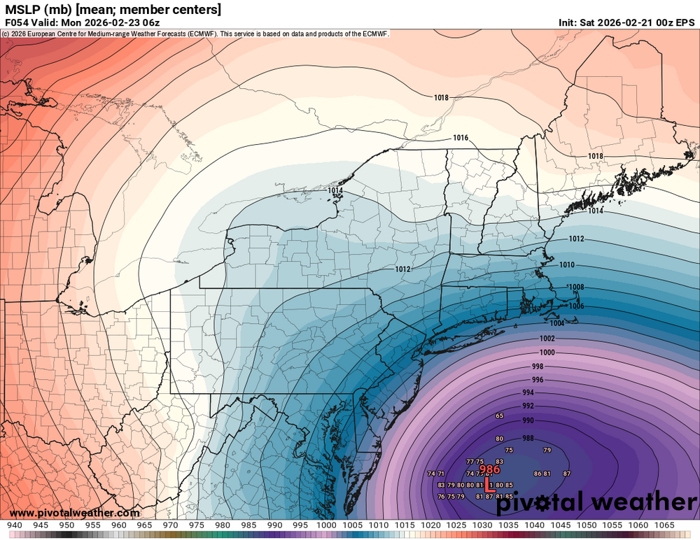
At hour 48 the mean MSLP is East of 18Z run, and looks to be almost exactly where the OP LP is. Backs up the OP
-
Eps
-
Either the GFS or EURO are totally wrong. Whats weird is it starts with the difference in northern stream about 6 hours out. So strange and unprecedented to my eye.
-
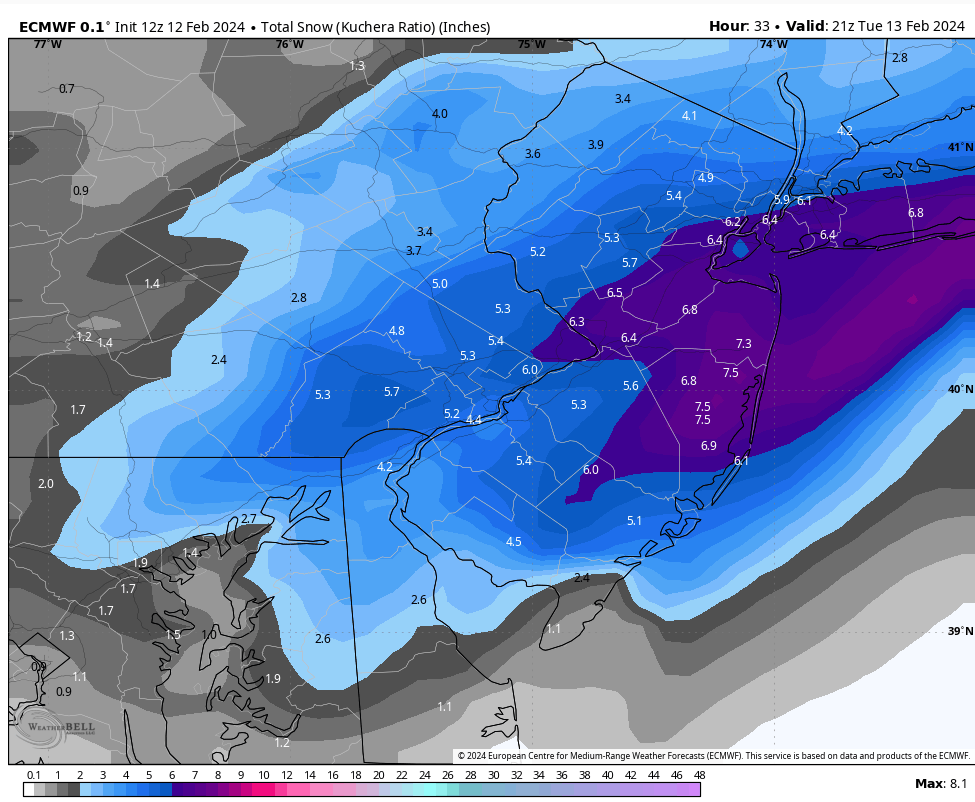
In case anyone is wondering about a situation in which the Euro failed spectacularly in the short range. This is from 2 years ago.

-
They were deleted.
-
Look at the upper levels. A lot going on with the vorticity interplay. Subtle differences aloft impact what happens at the surface- specifically the surface low development and track. Lets look at the latest GFS, CMC , and Euro at h5-Best outcome to worst. It really comes down to the strength, timing, and the angle of the individual pieces of vorticity and how they phase, which impacts the tilt of the overall trough. One of the above looks a bit different than the other 2. Pretty subtle, but different.
-
Looks like 6" will do it here, Nice event, On to mid late next week.
-
The EURO is not what it was 6 years ago.
-
No rain or freezing rain during the February 1978 blizzard (except possibly right near Montauk for a bit, but I'm not sure). You might be thinking of the big January near blizzard that year which ended as a mix. Temperatures prior to the Feb 6 storm were very cold (near 0 on LI the morning of the 5th) and well below freezing except for a couple of hours late on the 6th from ISP south and east as they got involved with a coastal front and the temp rose to around freezing. We had snow up to my keester but my most vivid memory is the wind; it was insane.
-
PSA - I’m proud to see no LR HRRR or SREF plumes on here. Way to go team.
-
The Euro is why forecasters are hedging That a huge difference from gfs
-
Yeah but this is even more extreme. The middle here wouldn’t be so bad.
-
Yes what I meant. Sorry lol .
-
It is but Dr. No just has to ruin it a bit - lol. Hopefully tomorrow things keep going positive.
-
East?
-
.thumb.png.4150b06c63a21f61052e47a612bf1818.png)
“Cory’s in NYC! Let’s HECS!” Feb. 22-24 Disco
HIPPYVALLEY replied to TheSnowman's topic in New England
Shocking! -
Look no further than a week ago. GFS had 6 inches, RGEM had nothing. End result was somewhere in the middle.
-
This entire suite stood pat or even trended a little further west. Only Exception was euro OP. .
-
Perfect example of why you go conservative on qpf totals until you get closer in, Most seasoned mets have the right idea and knowledge to not forecast on emotions then social media wannabe's looking for clicks.
-
I just saw the Euro. WOW, only 4 inches for our area. Yet the American models are close to 2 feet. Insane difference. I do think the Euro is way off with this solution, but it isn't a slam dunk yet that we're seeing a monster event.
-
Crap I’m sorry to hear that. Does insurance cover that?
-
Yes! Isn't this exciting
-
100% agree that the GFS has been rocksteady while other models have moved its way. 00z NAM / RGEM / ICON all got close to a GFS outcome, but hit the shore and NE with the best goods. Would be one hell of coup if it’s right. But I’d caution dying on the GFS or bust hill. I’d argue that the euro, while trending better the past 24-36 hours, has been relatively consistent in showing what is interfering with a bomb out solution for our latitude — the trailing energy — albeit to varying degrees. It def shouldn’t be ignored. The western ridge is so so crucial here. My guess is that by 0z tomorrow, we should either see a consensus solution emerge between the two or the euro move closer to the gfs. Would be pretty wild to see the GFS hold this all the way thru but I guess crazier things have happened. Also, that inverted trough throws a huge ? Into this storm. Some area between 15 and 95 will see a rather impressive bonus. I’d HATE to be NWS trying to make a forecast for the area from Winchester to Baltimore down to DC right now.


.png.b82d60dd45edb2c53f1d17bfb2b97719.png)