All Activity
- Past hour
-
Agree Nam is still an outlier
-

Boxing Night Snow/Sleet/Ice Dec 26-27 Storm Thread/Obs.
Voyager replied to Mikeymac5306's topic in Philadelphia Region
Depends on one's view of low impact. For me, as a tractor trailer driver pulling a bulk liquid tanker, a sleet and ice mess isn't quite low impact. Now, since you're a Penndot guy, do you see the Tier 3 restrictions holding, or do you think they might be downgraded? As of right now, legally, I should be off the roads by 2pm, loaded or empty. That to me is a blessing as it gives me leverage to park the truck without (hopefully) any repercussions from my employer as it'll technically be illegal for me to be out on the highway. I may be an experienced, professional driver, but I really don't want to play in sleet and ice in the mountainous region in which I run. -
23 here
-
Such an odd track diving southeast, enjoy the snow guys! At 21F now, stinks with solid cold in place I won’t be able to get more out of this - but yeah, odd track and it’s expanded north. Nice storm though!
-

Boxing Night Snow/Sleet/Ice Dec 26-27 Storm Thread/Obs.
penndotguy replied to Mikeymac5306's topic in Philadelphia Region
24F DP10 NE wind@10mph with P Cloudy skies. Looks like a low impact storm out this way still going with 1-3" snow/sleet, and maybe .10" of freezing rain looks to be over well before daybreak tomorrow. Then we wait for the rain and mild temps Sunday night into Monday. -
6 am. 10 hours ETA. Let's do this. I'm pumped.
-

26th-27th event, coming at us like a wounded duck.
Ginx snewx replied to Go Kart Mozart's topic in New England
Definitely like we are losing the LBNW look, more expansive qpf. -
18/8 bone chilling cold. Up in the air on what to expect here. Could be 4-8”, 5-9” I’ll say right around 7” is my bet.
-
14/5 expecting 8-10” here
-
3-6pm
-
23 degrees in Kearny with a crystal clear night sky. Manhattan skyline looks incredible all lit up.
-
What time we looking at first flakes around nyc?
-

26th-27th event, coming at us like a wounded duck.
Damage In Tolland replied to Go Kart Mozart's topic in New England
Honestly who cares what they have though? All they do is use the HREF. As that increases today , so will they -
26th-27th event, coming at us like a wounded duck.
Damage In Tolland replied to Go Kart Mozart's topic in New England
I’d call it nervous excitement but feeling like 6+ is fairly likely -

26th-27th event, coming at us like a wounded duck.
Sey-Mour Snow replied to Go Kart Mozart's topic in New England
They will, nothing stopping it now. -

26th-27th event, coming at us like a wounded duck.
Modfan2 replied to Go Kart Mozart's topic in New England
BOX not currently biting on higher totals for our area and points east, will see if this changes during the day -
26th-27th event, coming at us like a wounded duck.
Sey-Mour Snow replied to Go Kart Mozart's topic in New England
You must be pumped right now -
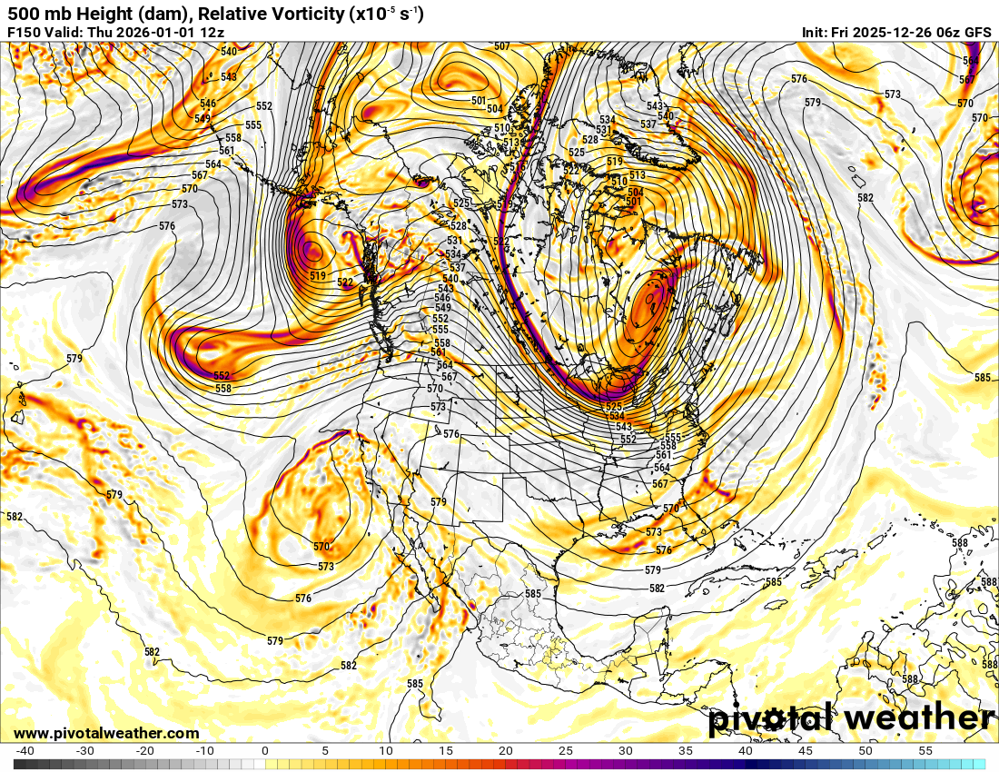
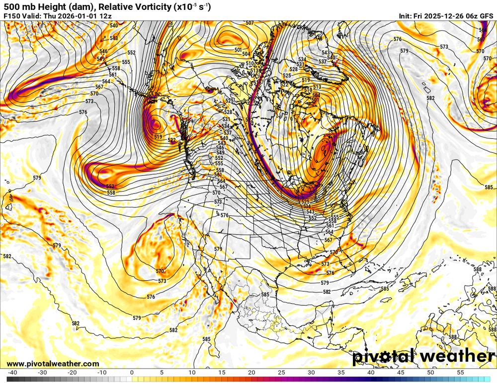
Watch that. If you can squeeze even a slightly more amped ridge in the west here, this quickly becomes really interesting with a block in the Atlantic.
-
26th-27th event, coming at us like a wounded duck.
Damage In Tolland replied to Go Kart Mozart's topic in New England
You got three ticks north -

Winter 2025-26 Medium/Long Range Discussion
A-L-E-K replied to michsnowfreak's topic in Lakes/Ohio Valley
Yeah first fantasy cutter in a while, hopefully our doldrums end before too long, it's been way boring -

26th-27th event, coming at us like a wounded duck.
kdxken replied to Go Kart Mozart's topic in New England
-
UK held or slight improvement. The trend towards shifting the lows northeast and delaying their decay/shunt south is leading to a more north-south oriented snow accumulation distribution as it pushes moisture into the damned cold air. There will likely be a snowfall max now in ENY with excellent ratios. But if we can hold off mixing, our QPF might get a boost leading to a 2nd max further south near NYC or the HV but with lower (still decent) ratios.
-
A little warmer in the Midwest.

- Today
-
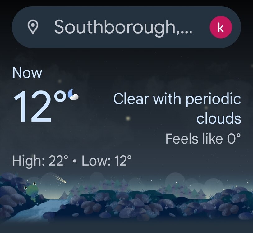
Brrr 12° with a wind chill of zero
-
26th-27th event, coming at us like a wounded duck.
kdxken replied to Go Kart Mozart's topic in New England
Can you post a couple maps please?