All Activity
- Past hour
-
Yeah agree with Brian. Probably a lot of 98-99 with some spot 100s. Only thing that mighty argue for a 101 is that per GFS...we mix deeply and dews mix out. That might help offset the 850 Ts.
-
Nice and cloudy out there.
-
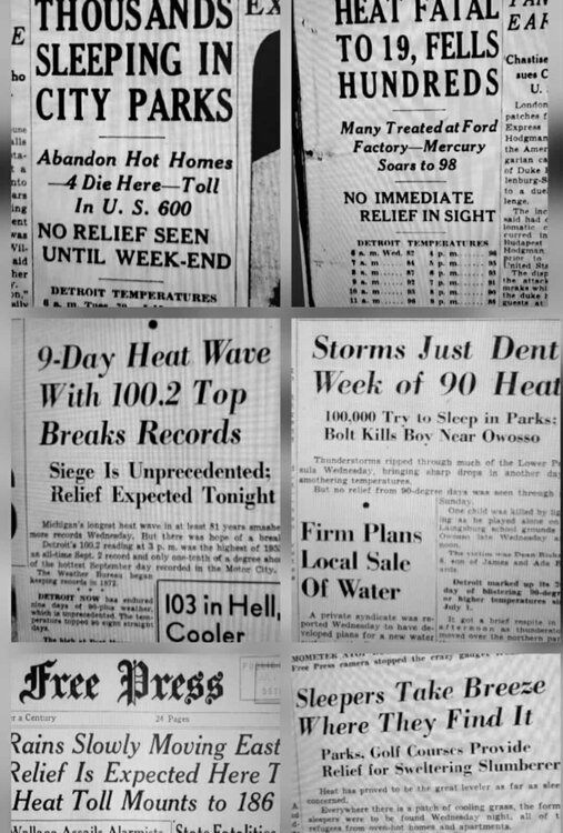
Heatwaves were just brutal in the 1930s-50s...with no AC
-

Occasional Thoughts on Climate Change
LibertyBell replied to donsutherland1's topic in Climate Change
but here in the northeast our air has become more humid and more cloudy, I compare years like 1944, 1948, 1949, 1953, 1955, 1966, when it was far easier to hit 100+ in drier air than it is now. Our cloudiness has increased since that earlier, much drier era. -
a couple of beaches on Long Island are closed because of elevated bacteria levels thanks to excessive rainfall and runoff from hazardous chemicals....
-
 but consider that forecasters do not like egg on their face so to speak... none of us like to be wrong. In this case confidence is high that problems will develop of the magnitude described. Yes watch is less confident than warning,
 -
Really quite extensive tree damage in takoma park. Some big ones down.
-

2025 Spring/Summer Mountain Thread
Met1985 replied to Maggie Valley Steve's topic in Southeastern States
An awesome summer day today. My high today was 75 degrees. It's going to get warm but it's summer. Nothing new -
Busy w granddaughter but I think terminology has changed. UNUSUAL for NWS to issue a watch 3-6 days in advance. Confidence high on problems. In the Deep South they might handle it better?? but here its sudden onset and magnitude. Ensembles continue 100+ for the I95 corridor.
-
So many leaves and twigs ending up in the pool today
-
We got a few bass, pickerel, yellow perch and good size American Eels but never any bullheads. Do you know if it ever produced those?
-
And the sun is breaking back out, just a light shower. Sorta felt (and looks on radar/satellite) like a winter snow flurry/shower. It MIGHT have touched 0.01 in the gauge, I'll check later. Temp 'bottomed out' at 73.0, which is current. More clouds forming out to the W and NW in WV, so it may sprinkle or light shower again later.
-
usually it's 3-4 mows. It's been like 8 mows and they are still growing.
-
5.21" for the month o June so far following 7.62" for May. 12.83" since May 1st.
-
 a excessive heat warning is when temps and humidity are basically guaranteed to reach a certain criteria while a extreme watch is not as confident the criteria will be met..
 -
Yep, I'll have at least a 'T' to report, light rain falling. ONE shower on radar, right over me ATM. Temp down to 74.3/59.0.
-
so it's made it to 81 F here same next door at KFIT.. It's a weird combination getting these canopy leaner wind gusts at that warm of a temperature. ...just anecdotally.
-
Good friend lives out that way. Just sent me this about an hour ago. I love the West.

-
Same page ... This has evolution room, tho. It's really almost ideal. So we'll see, but for now. If it's 98/72 ... it's not going to make any difference if it's 101/72 save posterity perhaps. Also, many times I've seen big heat, for 3 hours in the afternoon the 72 DPs slip to 66ies while the temperatures are at apex.
-
LOL, clouds have moved in, and it looks like a shower could fall any minute, dropped temp to 77.6/58.5. High was about 30 minutes ago at 81.1. Although warm, I'm definitely liking the lower dew points!
-
Enjoy! One of my favorite places. Doesn't look like you'll get a thunderstorm today. That's a rarity.
- Today
-

Occasional Thoughts on Climate Change
Typhoon Tip replied to donsutherland1's topic in Climate Change
no shit ( bold ) I've started bringing this observation up about 15+ years ago actually ... long before it even showed up in papers, that the HC was appearing to be enlarged(ing). I have been relating it to winter gradient steepening and the observed increase in basal geostrophic wind velocities - also the jet cores them selves have quickened. Lot of air-land speed record on west --> east flying commercial air craft over the Pac and Atlantic flight routes in the last 20 years. Anyway, it's effecting storm morphology... and precipitation distribution as well as frequency in the winter. But the cloud aspect ... yeah that's interesting too. -
Occasional Thoughts on Climate Change
LibertyBell replied to donsutherland1's topic in Climate Change
I'm thinking cloud cover is actually increasing in the northeast though, just going by how much wetter our climate has been getting. -
Imagine this forecast on the Summer Solstice... Glacier National Park. We can't even get that in January. Also, yes it is at elevation, but they are going to see snow levels down to like 5,000ft. It's not *that* high up (this point and click is like 6,000ft). Would be like Mount Washington getting plastered on the solstice. Saturday... Snow. The snow could be heavy at times. High near 31. West southwest wind 15 to 18 mph, with gusts as high as 25 mph. Chance of precipitation is 100%. New snow accumulation of 14 to 20 inches possible. Saturday Night... Snow. The snow could be heavy at times. Low around 28. West wind 11 to 14 mph becoming north northwest after midnight. Winds could gust as high as 20 mph. Chance of precipitation is 100%. New snow accumulation of 4 to 8 inches possible.
-
 https://www.weather.gov/news/250310-heat-hazard NWS is renaming its Heat Watch and Heat Warning products to improve messaging. On March 4, 2025, the NWS will implement the following changes: Excessive Heat Watches will be renamed to Extreme Heat Watches. Excessive Heat Warnings will be renamed to Extreme Heat Warnings.


