All Activity
- Past hour
-
Considering NWS has me in 18-24” “could get a foot” seems reasonable. I’d go 8-12 for my area no idea what NWS is smoking.
-
Richmond Metro/Hampton Roads Area Discussion
RVASnowLover replied to RIC Airport's topic in Mid Atlantic
Big improvement on the 00z euro. Hope we see improvements all around today -
Looking at the euro runs for 18z and 0z I’m thinking DC and surrounding areas get the floor, Baltimore and surrounding areas get the ceiling. So I think your area could get more than a foot.
-
Please go back to lurking....what did you add here?
-
Warnings coming with the new AM AFD based on the AFD from 1am. Going with front bump SN to sleet . 1-3” sleet to FR. Ready to track the realtime surface features. .
-
0z eps and 6zgefs both increased the 10% snowfall quite a bit across the area indicating the chances for a low end bust went down. The 10% snowfall on the EPS is still around 6” in DC and 9” up here. That’s a pretty decent “floor”. GEFS is significantly better of course but it also increases the floor.
-
-
I was thinking the same. This reminds me of a few storms from the early 2000s. Models 72 hours out showed us getting crushed, ended up with about 4-8 with sleet.
-
“Cory’s in LA! Let’s MECS!” Jan. 24-26 Disco
wx_observer replied to TheSnowman's topic in New England
Today's 3:33 AM Winter Storm Watch text now has an 8-15" storm total for the region. That's a lot of bumping down totals in a pretty short time frame, compared to that first snowfall map that came out at 1am that showed a bunch of the south shore at 18-24". -
The last time I remember a SWFE type storm was in winter 2000. I remember it because the commute from Farmington to Simsbury was near impossible in my shitconoline van. Was supposed to be a couple inches and between 11 am and 4 pm we had near 10 inches. I don't remember if there was coastal development with that one, but I don't believe so. This has so much potential, hopefully we cash in
-
Fingers crossed Baltimore is still within striking distance of the ceiling.
-
Busy times ahead!
-
Yep. This is the kind of storm I've often seen when I was a kid. PA gets the most snow while we mix. I was jealous of State College then. But they've had a terrible, terrible run at snowfall in recent years. Like, worse than us.
-
We knew that would likely show up at some point. NAM... see you at 12Z
-

Possible Record Breaking Cold + Snow Sunday 1/25 - Tuesday 1/27
MJO812 replied to TriPol's topic in New York City Metro
-
That’s climo.
-

Central PA Winter 25/26 Discussion and Obs
mahantango#1 replied to MAG5035's topic in Upstate New York/Pennsylvania
ABC27 going on the lower side while my NWS is 15-22 snow -
Yeah I’d feel good with 12-18 forecast but not good about brushing 18”+ over anyone. I do think the south shore and Cape Ann have a pretty decent shot though with the extra OES enhancement. Still uncertain about how efficient monday is….on one hand, we’re synoptically dryslotted, but OTOH, you are literally in the DGZ sfc-700mb so it might not matter that much if you can generate some steady light precip…you could stack another 4-6” with maybe a quarter inch of QPF.
-
I had almost 10" of cold smoke last January. No mix, no drama. Just a beautiful snow followed by cold. I'm just frustrated as always watching pa get crushed by our storm lol
-
Pittsburgh/Western PA WINTER ‘25/‘26
SteelCity87 replied to Burghblizz's topic in Upstate New York/Pennsylvania
As someone who works overnight the hardest part about this storm may be how to not miss the morning/afternoon show lol. -
How do they come up with these maps? I ask because how it has that tear drop of 12" over Dover Delaware. I've never seen that before.
-
probably why ALY took totals down a bit here, and I'm still sticking with 10-14 here anyway, we'll see how the next 24 hours look model wise, but no closed low has me concerned about long duration and CCB type snow of any real accum..
-
That may be, but your backyard is still well within the 8-10” range before a flip. Of course that could still change, but you haven’t received that much in a single storm in 10 years.
-
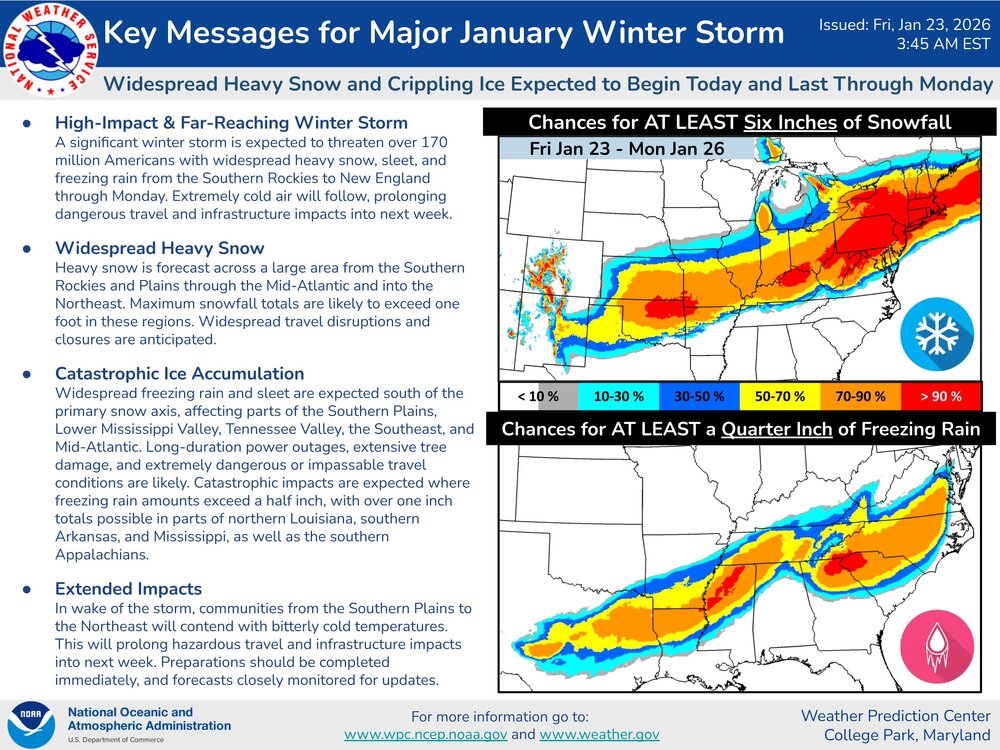
Now the GFS gives southern Louisiana across Mobile, and all of the Florida panhandle 8-12 inches of snow with 0 warm nose issues 150 miles north of the low. Yet here we see 850s shoot to 50 degrees with a low 1000 miles south of us. It finishes off with a band of ocean effect snow that sends 2-4 inches from Tampa Bay down towards south Central Florida. While this clearly shows that the GFS probably needs to be decommissioned and a new model launched in its place, I wouldn't be shocked if it came true.






.thumb.jpg.7148fd4005ddcee691c6284de042872c.jpg)


