All Activity
- Past hour
-
Gonna miss MBY and barely rain here. Bust
-
The area between Pikesville and Columbia (Catonsville area) has been hit all year. All that I got was a few drops out of this storm.
-
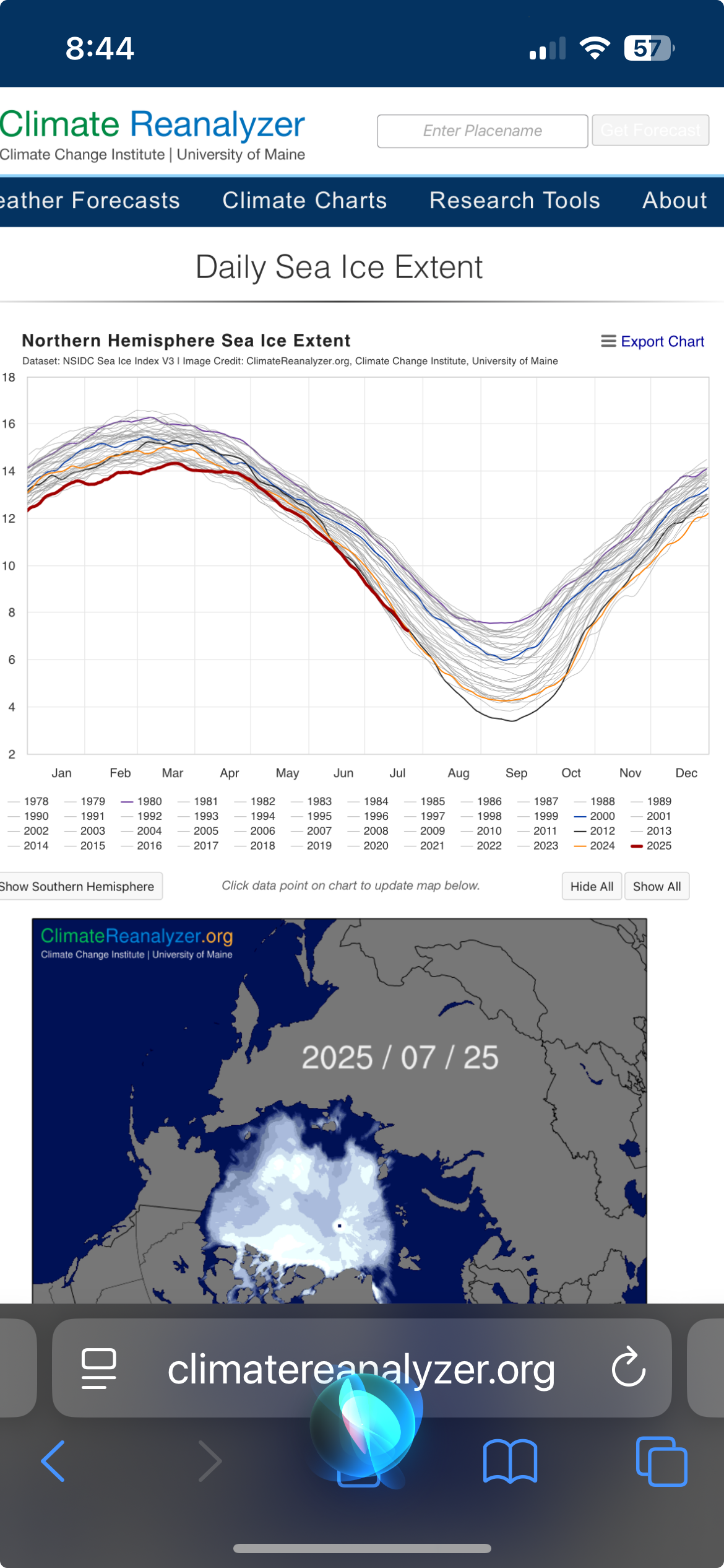
Is this right from the university of Maine? looks like we’re presently a tick below 2012

-

2025-2026 ENSO
Stormchaserchuck1 replied to 40/70 Benchmark's topic in Weather Forecasting and Discussion
Look at how much this cold pool is blowing up on TAO/Triton CPC usually lags a few days to weeks. -
Emptied the bowl but play continues. What a joke.
-

2025-2026 ENSO
donsutherland1 replied to 40/70 Benchmark's topic in Weather Forecasting and Discussion
I don’t believe he is aware of the origins and flaws of the chart. Moreover, he isn’t a troll. In the meantime, a photo from Stonington, ME where it got to 84. Portland hit a record-tying 91, but the heat was tempered here thanks to some showers and considerable cloud cover. The clouds broke during the late afternoon.
-

July 2025 Obs/Disco ... possible historic month for heat
Torch Tiger replied to Typhoon Tip's topic in New England
if you saw a strong storm, it was a top 5'er all day -
18z GEFS actually really gets us cool Aug 1-7. Could open the month with a -3 to -4 first week, per the ensemble mean.
-
 Am fairly satisfied with D1... plenty of svr and narrow streaks of 1-1.5". Even 100 at KEWR and daily RER's here and there. Letting late Sat-Sunday play out. Am confident pockets of FF-SVR, ,mainly NJ-LI... Buoyancy will pretty good, better Bulk Shear and larger PW near 2.4". Let's see what happens.
 -

July 2025 Obs/Disco ... possible historic month for heat
DavisStraight replied to Typhoon Tip's topic in New England
My wife said we had a Tstorm here, brief with a downpour, I wasn't here at the time. -
July 2025 Obs/Disco ... possible historic month for heat
Torch Tiger replied to Typhoon Tip's topic in New England
Today was one of the best days of the summer, hands down. Perfect temp/dew, storms bubblin', can't ask for more. Top 10 at least -
Lots of lightning in view here at oriole park. Looks like the bulk of it might drop between Baltimore and Columbia.
-

July 2025 Obs/Disco ... possible historic month for heat
RUNNAWAYICEBERG replied to Typhoon Tip's topic in New England
Reach for the backside then for a slice? -
July 2025 Obs/Disco ... possible historic month for heat
Torch Tiger replied to Typhoon Tip's topic in New England
I love the HHH too, but you okay bro? -
Good quality sounding booms off to my north (from Columbia). Also some building cumulus at sunset in N&NW skies. Radar has something to the north, heading SE-ward so it could be a good hit …. or a swing and a miss. Will know shortly.
-
Picked up .63” out of that. Decent downpour and cooled it off to 77. Had some good thunder and lightning as well. Power went out once but reset.
-
I figured you would be. Even I'm watching it down here to your SE. It's unusual for storms over Carroll County to effect my area. It looks like there's some outflow running out ahead of it. We'll see.
-

July 2025 Discussion-OBS - seasonable summer variability
SACRUS replied to wdrag's topic in New York City Metro
LGA was 99 -
July 2025 Discussion-OBS - seasonable summer variability
SACRUS replied to wdrag's topic in New York City Metro
https://forecast.weather.gov/data/obhistory/KLGA.html Still not updating for me. Is there another source? -
Highs: EWR: 100 TEB: 99 LGA: 99 PHL: 98 TTN: 97 ACY: 96 New Brnswck: 95 NYC: 95 BLM: 94 * missing hours JFK: 93 ISP: 93
-

Texas 2025 Discussion/Observations
Powerball replied to Stx_Thunder's topic in Central/Western States
DFW only topped out at 98*F yesterday and 99*F today, so the 100*F drought continues... Looks like the top 10 list for latest 1st 100*F days may be in play now (starting with 8/7). Meanwhile, 1973 and 1906 are the only years in recorded history thus far that DFW didn't see a single 100*F day. BTW, the high of 98*F yesterday is also amongst the latest in the season DFW has recorded a temp that high, with the exception of 2002. -

July 2025 Obs/Disco ... possible historic month for heat
Snowedin replied to Typhoon Tip's topic in New England
My butt cheeks are literally covered in the dankest, moistest sweat imaginable. But you know what, I wouldn’t trade this for nearly anything. This is real summer all around. None of this 75/55 amateur bullcrap. After a nice steamy shower, a delicious pina colada and a fresh digornio pizza are gonna go down magnificently! -

July 2025 Obs/Disco ... possible historic month for heat
ineedsnow replied to Typhoon Tip's topic in New England
This is going to be fun to use for Hurricane season https://deepmind.google.com/science/weatherlab -

July 2025 Discussion-OBS - seasonable summer variability
Sundog replied to wdrag's topic in New York City Metro
Looks like LGA got to 99. -
I can hear the thunder…sounds like an active cell, but looks like it’s gonna stay south of my area.