All Activity
- Past hour
-

December 2025 Short/Medium Range Forecast Thread
Carvers Gap replied to John1122's topic in Tennessee Valley
Hour 276....we have some things to get worked out. The difference in the Euro AIFS and GFS ta 18z over Nashville is 58 degrees. The Real Feel on the AIFS is 3. The GFS is 61. The AIFS did not dig into the SW w/ the SLP FWIW, but it did the second. That still allowed a massive cold front to crash eastward on Dec 3 on the AIFS. -
Models converging on a little clipper moving through the area Sunday-Monday. Not much room but let’s amp that up a little.
-

2025-2026 ENSO
donsutherland1 replied to 40/70 Benchmark's topic in Weather Forecasting and Discussion
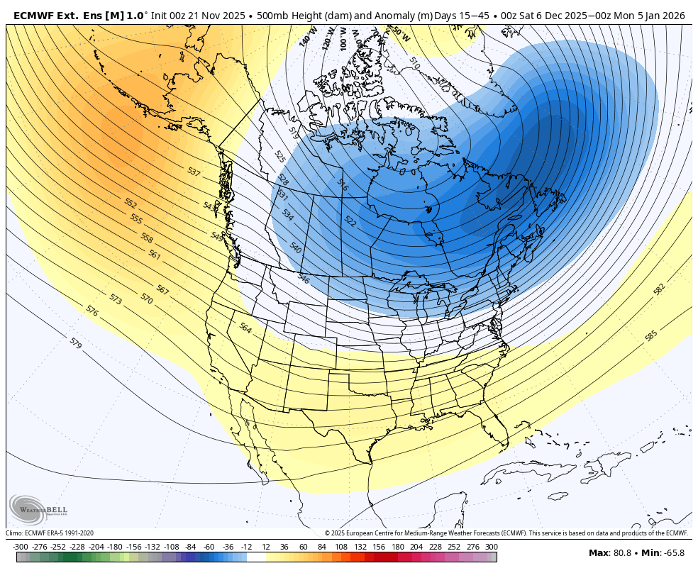
That's a great map. -
A generally milder than normal pattern will likely continue through next Wednesday. However, exceptional warmth appears unlikely. The closing days of November will likely turn colder. Meanwhile, today will be Central Park's 1,392nd consecutive day without daily snowfall of 4" or more. The record of 1,394 days was set during February 22, 1929 through December 16, 1932. That stretch ended with 6.7" daily snowfall on December 17, 1932. The ENSO Region 1+2 anomaly was -0.7°C and the Region 3.4 anomaly was -0.7°C for the week centered around November 12. For the past six weeks, the ENSO Region 1+2 anomaly has averaged -0.16°C and the ENSO Region 3.4 anomaly has averaged -0.65°C. La Niña conditions will likely continue through at least mid-winter. The SOI was +26.47 today. The preliminary Arctic Oscillation (AO) was +0.707 today. Based on sensitivity analysis applied to the latest guidance, there is an implied 83% probability that New York City will have a cooler than normal November (1991-2020 normal). November will likely finish with a mean temperature near 46.6° (1.4° below normal). Supplemental Information: The projected mean would be 1.1° below the 1981-2010 normal monthly value.
-
At least the storm track will not be too far south according to their Precip Outlook and the Polar Vortex is not going to plunge too far south when it is stretched by the Strat Warming Event according to their Monthly Temp Outlook. Heard that the Vortex will be stretching rather than a full displacement............
-
December 2025 Short/Medium Range Forecast Thread
Carvers Gap replied to John1122's topic in Tennessee Valley
Option 1(and there will sure be options 3,4, and 5!) is that the trailer vortex spins out to sea. That is the 18z version. Option 2 is what happened at 12z. The trailing vortex followed and dug out a huge trough which allows a third vortex to drop into. We need that first vortex (even if it goes to the FC...to dig less and kick earlier). I think the first vortex digging into the SW is legit. I am not sure I buy the second and third vortices doing the same - that smacks of feedback. If the second and third vortex simply "don't go to Baja" then the trough likely digs into the EC. Take a minute and looks at the little vortices which modeling is juggling. There are four rotating around the EPO ridge - not counting the Four Corners low. This set-up is an absolute thorn to work out. The downstream effects are huge. It will be interesting to see how this works itself out. OK, enough stream of though posting. It is Friday night, and I am chilling. Will check back later. -
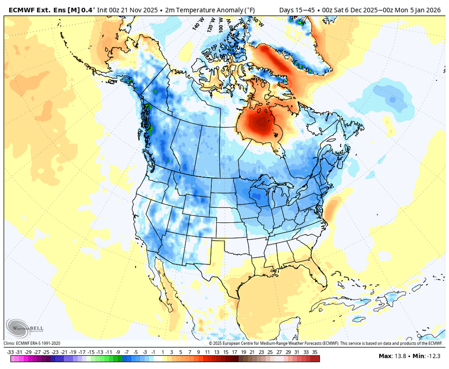
Fascinating the cold in the SW and the Baja. The deep troughs on the West Coast this year, and the last several, have been an issue leading to a SER. That 15 to 45 day map is interesting showing a cold anomaly from Alaska to the Baja.
-
December 2025 Short/Medium Range Forecast Thread
Carvers Gap replied to John1122's topic in Tennessee Valley
Night and day differences when the SW doesn't have multiple lows cutting off...I don't know which is right. But the 18z GFS gives me some hope that the multitude of cutoffs in the SW may well be a feedback error. -
30 day temps on the Weeklies beginning on the 5th look good as well.

-
Exactly, when you start the 30 day on the 5th, you factor out the last few days of the SE ridge in early December.
-
December 2025 Short/Medium Range Forecast Thread
Carvers Gap replied to John1122's topic in Tennessee Valley
The second vortex (which follows the Four Corners low) is the problem. During the 18z run it literally cuts directly through the ridge in the GOA. At 12z, it cuts over the top and dives into Baja which deepens the western trough. You can see the variations on the panels of the ensembles. About half have a trough in the East and half have a ridge - thanks to that little vortex. The EPO ridge is so tall that it is rotating energy back under it which is causing westward flow of Cali. If that vortex doesn't sit over Cali, I do wonder if Santa Anna winds might develop as a result. edit: When the first Four Corners low doesn't dig as much, it doesn't really leave much room for the second to follow. All of this is something to watch on future runs. Until this gets worked out, everything from Weeklies to deterministic runs are going to be impact IMHO. Why? That series of cutoffs takes almost a week to resolve. In other words, there are 5-7 days of cutoffs if not more (on previous runs). If we are looking at just 24-48 hours of a single, cutoff low...that allows for the trough to form in the East. It is a great example of the butterfly effect. The difference between record highs at 12z and the PV heading south at 18z....look nor further than the SW sequence. -

E PA/NJ/DE Autumn 2025 Obs/Discussion
Albedoman replied to PhiEaglesfan712's topic in Philadelphia Region
well drought guy, here. These pity rain events is killing us now. Just issued a drought watch for my water supply. The bad thing is that it did not come from PADEP or the USGS, it came from my water authority LCA. This is getting serious as this affects the water bottling companies as well as 200,000 residents in the LV. Where is 2-3 in rainfall from a noreaster? WeE can not even squeeze out a popcorn fart for a decent rainfall event. Every time I look at the models, the snow potential keeps getting push back to the middle of December too. Welcome to the arid tundra region again. https://www.lehighvalleynews.com/environment-science/lehigh-county-authority-declares-drought-watch-asks-residents-to-reduce-water-use -
December 2025 Short/Medium Range Forecast Thread
Carvers Gap replied to John1122's topic in Tennessee Valley
Look at the different in the eastern half of the US. The first low(now in the Plains) is shallow and digs less. The second vortex spins off the Cali coast(westward). Not sure how much of that is believable, but this illustrates what happens when perpetual lows don't form in the SW. -
December 2025 Short/Medium Range Forecast Thread
Carvers Gap replied to John1122's topic in Tennessee Valley
Just watching the 18z GFS run, it is already very different over the Southwest. The second shortwave does not dig over the Southwest. That yields an entirely different outcome. That subtle change illustrates how important that sequence is.... -
how bad was the concussion dude? did you get some severe personality disorder or something??
-

2025-2026 New England Snow Recordkeeping Thread
bristolri_wx replied to bristolri_wx's topic in New England
I did! But unfortunately work has been very busy, and November is also a busy family month (wife's birthday, wedding anniversary, son's birthday). I plan on adding this weekend. Thankfully everyone can retroactively add snow reports when needed. -
That being said, last winter was BN and snowfall was AN to NN from central NC to the coast. Weeklies weren’t bad last winter at all
-
These last 2 days were only virtual days. Next week new job training actually starts in Kearny, nj.
-
December 2025 Short/Medium Range Forecast Thread
Carvers Gap replied to John1122's topic in Tennessee Valley
Haha. I know I have lived this discussion before! Take a look at the very FIRST thread on the forum. Read until you get to John's map on Dec 15th. This is why I love this site...we can look back at other winters. And look at that map - mega dittos!!! I have no idea what the SSTs or ENSO were at the time, but wow....similar. My intent was to start at the first thread, and find where we have had this conversation before during December. I am sure there are others, but LOL...it is great. Also, google our forum for Baja cutoffs. Lots of great discussion for those. -
Maybe I’ll make my return.
- Today
-
His map is misleading because it’s starts at Dec 2 which will include a probably severe Se ridge which will skew the map
-
I think the differences are mainly noise on such a forecast product like the weeklies that far out.
-

November 2025 general discussions and probable topic derailings ...
Typhoon Tip replied to Typhoon Tip's topic in New England
The majority doesn't appear to have this right, anyway. There is no SSW.... there never was yet. There may be one about Dec 7 or so... but antecedent to the -WPO/ -D(EPO) that was not the case. This is a ridging that is emerging from mid to upper troposphere and the tropopausal heights are elevated around the N arc of the ridge at upper levels; that does have an effect on the morphology of the PV. As I explained the other day, it may be splitting hairs? Either way, a -WPO/-EPO arc can arrive into that scenario however it does, when it gets into that mode, we load ... cold air in the winter. The cold you noted in Canada ( 2-meter temp anomalies... and 850...etc), that is a direct result of the activated loading pattern. This is just -WPO/-EPO, nothing else. Not sure why social media can't help itself but go from 0 to sci fi drama with such little excuse to do so - sometimes I suspect it's society dopamine plague since we've become tech zombies. How's that for sci fi. jesus As far as the colder pattern, this is all greater confidence than people are letting on - a lot of which I suspect is not having patience. Part of the problem of visualizing these changes at long leads ... ( over 15 days in some case...), about 5 days in waiting all the doubts start happening ... People expect to see things now. Meanwhile, models will come in and out of the signal ( operational versions). By the way, here's the 360hr 10 hPa GFS prog... this is a warm intrusion - we'll see if it's real.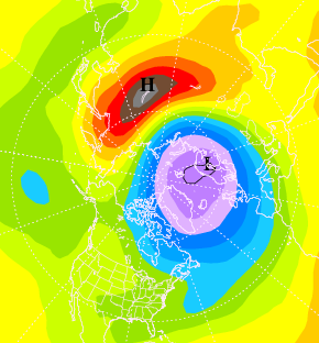
-

2025-2026 ENSO
michsnowfreak replied to 40/70 Benchmark's topic in Weather Forecasting and Discussion
Im sure he was referring to his location. I see no warmth at all in MI in the means. Doesn't mean there won't be a mild day or two. -

November 2025 general discussions and probable topic derailings ...
dendrite replied to Typhoon Tip's topic in New England