All Activity
- Past hour
-
I wonder how strong of an El Nino would be necessary to completely take the record WPAC warm pool out of the equation? Even during the 15-16 record super event, we still got the record MJO 5 for such a strong El Nino in December 15 leading to the +13 that month around NYC. Thankfully, there was a major improvement during January and February 2016. But our next El Nino attempts in 18-19 were too weak to fully couple due to that record WPAC warm pool leading to the strong La Nina background patterns. Then the borderline super event in 2023-2024 had the record forcing and SST warmth from the IO into the WPAC for such a strong El Nino. This lead to the record warmth and 500mb ridging in Canada extending down into the US with no Nino trough development in the East.
-

December 2025 regional war/obs/disco thread
TauntonBlizzard2013 replied to Torch Tiger's topic in New England
Ukie sucks here lol, but does look a bit colder -
I think everyone who is making bold predictions on rain vs. snow and amounts 5 days out should at least post some evidence to back up their statements with - can't just go from past memories.......
-
Ukmet
-
Indeed it is
-
I'm interested to see the 12z Euro.. starts in a few minutes
-
Most likely outcome yes. Actually most likely is little to no accumulation or all rain but too early to say what the best possible outcome is
-
That’s very relevant for a ton of us. Congrats everyone!
-
Waiting for the Euro. Just checked the Turkey and it’s about ready, so I got time.
-
Euro being east should be a caution flag for amped solutions. So far this upcoming system has been behaving quite well. Models are jockeying for position so fade the big swings.
-
12z Ukie smokes BR and west
-
Usually anything from like 1-3 to 3-5 is most common. Some rare instances where 6-7 has occurred for the coast like February 2008 November 2018 December 1990 but those usually consist of one of two scenarios. Weak waves vs amping lows or the system approaches more from down in the Carolinas vs the Tennessee or Ohio Valley.
-
Correct. For me I still like watching the approaching rain/snow line and seeing how much accumulation we get before we flip. Sometimes up to 8 before a flip to drizzle occurs.
-

December 2025 regional war/obs/disco thread
Typhoon Tip replied to Torch Tiger's topic in New England
Perhaps too early to drill into details but a flatter wave correction toward middling low depth will tend to parallel the flow with the isobaric layout … basically an ENE vs a NNE/NE with cf genesis … that’s going mean snow tot headaches for eastern zones. -
Wake me when snow solutions pop up 24hrs before it starts
-

December 2025 Short/Medium Range Forecast Thread
Matthew70 replied to John1122's topic in Tennessee Valley
Happy Thanksgiving to ALL! -
good luck trying to figure this out - like I have been saying the GEFS,EPS and Euro AI never had an amped up system to begin with this is still 5 days away there will be more changes in the models,,,,,,,,,,,,
-

December 2025 Short/Medium Range Forecast Thread
Carvers Gap replied to John1122's topic in Tennessee Valley
Happy Thanksgiving, everyone!!! The 12z CMC looks close to something good late in the run. -
The meteorologist who posted that tweet is actually a huge cold/snow weenie and usually finds any excuse to go cold/snowy. He is actually the furthest thing from a warmista. As far as the MJO going into a clean phase 8 with amplitude, without any destructive interference from the standing wave by the Maritime Continent….I’ll believe it when I see it. We have played this game before with MJO phase 8 (23-24) and we lost badly. I’m not saying it can’t happen, but as of right now, color me skeptical
-
-
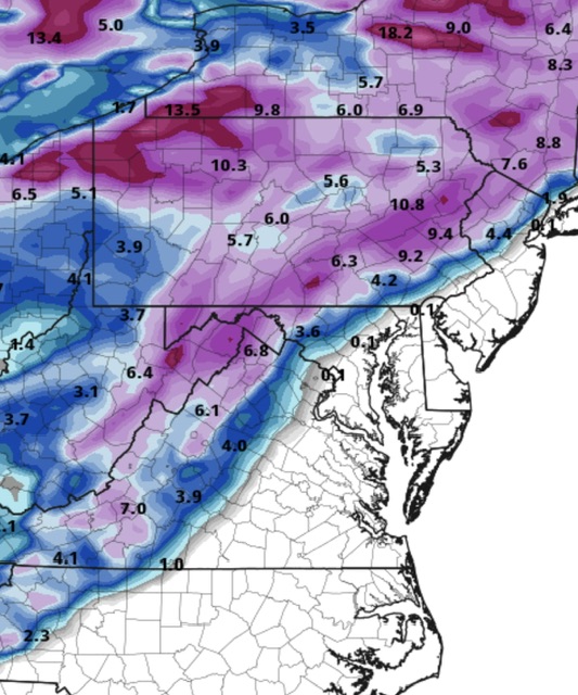
128 gradient
-
.thumb.png.0b195d6eac1d14fab437bf33de2c1d05.png)
-
whiffing is still on the table sir
-
don't those suck for our area, usually 3-5 inches and than either turns into rain and or icy in suburbs. Never an all snow event
-
Not a snowball's chance in hell. Best possible outcome for central park is a couple slushy inches---> rain.


.png.140383fb5893796b8940c2f9bca03215.png)

