All Activity
- Past hour
-
That was wire to wire frigid.
-
Outside of those that get a lot of direct sun, I don’t see the pack going anywhere really. Just a slow gentle melt outside the sunny spots.
-
Well guys, we had a good run. Time to enjoy the incoming thaw and see what March has in store.
-
It is a bright sunny one. It's colder than I expected this morning. It looks like I'll make 3 weeks without seeing the grass imby. Thanks! It's sounds like you have some great spots in mind. You might like Davis out in WV. It's not far but pretty wintery for a local spot. It's beautiful out there.
-

Is we back? February discussion thread
Damage In Tolland replied to mahk_webstah's topic in New England
Hopefully leaves everyone with pack -
As you wish.
-
More a social commentary here ... First of all ... no one should take advice off anyone from a social media source. To point out the obvious, it's no different than subjecting one's self to bus-stop factoids among strangers. Unless one really really knows that source. Like really knows, not because they think they know, but really do. In which case, your proooobably not reading their advice off a social media realm in the first place. hahaha No but what you can do, if you hear or read something that sounds cogent, use that as a step stone in research to go look the shit up yourself and see if its real. This latter tact seldom appears to concern those that frequent this source - that's sort of what I mean by not taking it seriously. Or maybe it is just lazy. Maybe it is just capacity to understand. Maybe compos mentis... Who knows for certain. Being the cynic that I am (perhaps even recreationally LOL) I think it's because people don't want to admit when one person or source is right - particularly ( in here..) when that right sounding advice or observation or whatever tact, cancels their joy. Folks are not in here ( probably neglecting what they're supposed to be doing, much of the time - ) to engage so much in objective lucidity.
-
Ya that December 81 was a nothing burger here.
-

E PA/NJ/DE Winter 2025-26 Obs/Discussion
No Snow Flo replied to LVblizzard's topic in Philadelphia Region
No Sno Flo says it's time for the snow to go! -
Records: Highs: EWR: 65 (1957) NYC: 64 (1951) LGA: 65 (1951) JFK: 56 (2023) Lows: EWR: 4 (1979) NYC: -1 (1914) LGA: 8 (2016) JFK: 0 (1967) Historical: 1784 - Ice floes blocked the Mississippi River at New Orleans, then passed into the Gulf of Mexico. The only other time this occurred was during the "Great Arctic Outbreak" of 1899. (David Ludlum) 1885 - The "Friday the 13th" avalanche at Alva, UT, killed sixteen persons, and left thirteen others buried for twelve hours before being rescued. (David Ludlum) 1887: Chicago, Illinois: Chicago's temperature rises from 0 °F on the 13th to 58 °F on the 14th. The 58 °F rise is the biggest day-to-day rise on record. The city will experience a similar jump in temperature in March 1972. (Ref. WxDoctor) 1899 - It was the coldest morning of record along the Gulf Coast. The temperature dipped to 7 above zero at New Orleans LA and Pensacola FL, and plunged to -1 degree at Mobile AL. The mercury dipped to -2 degrees at Tallahassee, the coldest reading of record for the state of Florida. (David Ludlum) Minden, LA -16°, trace of snow recorded in Fort Meyers, the farthest south that snow had been officially recorded in the US until the Miami snow of 1977.(Bob Ryan's 2002 Almanac) The temperature in Louisiana plunged to -16° below zero, a record for the state. (Ref. High and Low Temperature for the US ) New Orleans, Louisiana: After weeks of bitter cold, residents of New Orleans find ice 2 inches (5 cm) thick on the Mississippi River. The river reportedly is frozen from its source in Minnesota almost to its mouth in the Gulf of Mexico. Chunks of ice float out into the Gulf. (Ref. WxDoctor) 1899: The "Snow King" storm was a its peak on the afternoon of the 13th with wind speeds of 35 mph and gust of 48 mph and a temperature that remained in the single digits throughout the storm. By the evening of the 13th the storm had ended with a total of 34.2 inches of snow on the ground in Washington. Of that amount, about 20 inches of snow fell during the blizzard. The water equivalent of all the snow events was 3.69 inches. Over 40 inches of snow was on the ground in areas south and east of DC. Drifting was generally 4 to 6 feet ;however, some drifts were as high as 15 feet. In areas of upper Montgomery County, railroad cuts filled with drifting snow to a depth of 20 feet. Both PA and OH had an all time record low temperature of -39 °F, Staunton, VA had 40-50 inches of snow on the ground and Salisbury had more than 50 inches. (p.53 Washington Weather Book 2002 by Ambrose, Henry, Weiss) 1905 - Morning lows of -29 degrees at Pond AR, -40 degrees at Lebanon KS, and -40 degrees at Warsaw MO established all-time records for those three states. (The Weather Channel) 1905: Freezing temperatures were recorded over the states of Oklahoma, Arkansas, Kansas, and Missouri. Morning lows of 29 degrees below zero at Gravette, Arkansas, 40 below at Lebanon, Kansas, and 40 below at Warsaw, Missouri, established all-time records for those three states. The low temperature at Vinita, Oklahoma, plummeted to 27 degrees below zero. The temperature would be tied at Watts in January 1930 and Blackwell and Medford in February 2011. The negative 27-degree reading is cold enough to be the 2nd lowest temperature on record in Oklahoma. The coldest is currently 31 degrees below zero, recorded at Nowata on February 10, 2011. 1958: Tallahassee, FL recorded their largest snowfall on record. Close to 3 inches fell in 5 hours during the early hours. (Ref. Wilson Wx. History) 1962: St. Louis, MO recorded their low temperature record for the month as they dropped to -18°. (Ref. Wilson Wx. History) 1981 The highest barometric pressure ever recorded at the Reagan National Airport of 31.06 inches of mercury the previous record was 31.01 set on January 27, 1927.(Ref. Washington Weather Records - KDCA) (Ref. Wilson Wx. History) The highest barometric pressure ever recorded at Richmond International Airport was 31.04 inches.(Ref. Richmond Weather Records) 1987 - A storm in the western U.S. produced heavy rain over central California. Chews Ridge reported nearly eleven inches of rain in 24 hours, and extensive flooding occurred in San Benito County. The Mount Rose ski resort in Nevada experienced a "white-out" with 60 mph winds and 36 inches of snow. (The National Weather Summary) (Storm Data) 1988 - Strong winds in the wake of a storm in the northeastern U.S., gusting to 60 mph at Oswego NY, produced six foot snow drifts in northeastern Ohio. High winds in the mountains of Utah, gusting to 106 mph at the Snowbird ski resort, contributed to a forty car pile-up on Interstate 15, near the town of Bluffdale. (The National Weather Summary) (Storm Data) 1989 - Showers and thunderstorms produced locally heavy rain and flash flooding from central Texas to western Pennsylvania. Up to ten inches of rain deluged western Kentucky in two days, with five day totals ranging up to 13.16 inches at Gilbertsville Dam KY. Flooding caused tens of millions of dollars damage, including 18 million dollars damage at Frankfort KY. (The National Weather Summary) (Storm Data) 1990 - A slow moving cold front brought heavy snow to Utah, Colorado and Wyoming. Big Horn WY reported 15 inches of snow, and up to 22 inches was reported in Utah. In Colorado, 8 to 12 inches of snow fell over the northwest suburbs of Denver, while 16 to 22 inches was reported in the high mountain elevations west of Fort Collins. Strong winds accompanied the heavy snow, and bitter cold weather followed in its wake. (The National Weather Summary) (Storm Data) 1995: A National Weather Service Survey Team concluded a weak (F1) tornado occurred at the General Motors Desert Proving Grounds facility in Mesa, Arizona. Moderate damage was observed. A roof was damaged, and about 20 vehicles were destroyed and moved around. One car was lifted, moved several feet, and set down inside a roped-off area containing solar exposure equipment. The tornado traveled northeast and lasted about five minutes. The image below is from the February 1995 Storm Data. 1999: The low at Fairbanks, AK dropped to -36° marking the 19th consecutive day with low temperatures of -35° degrees or colder, setting an all-time record for the location. (Ref. Wilson Wx. History) 2000: Late in the day and into the early morning hours of the 14th, severe thunderstorms spawned six tornadoes over southwestern Georgia that killed 19, injured 202, and caused $35 million in damages. An F3 tornado hit southern Camilla, killing 11 people and wounding 175 others in the town.
-
It's been a rough stretch. If we're done, I got about 10" total this winter and last winter and haven't hit average since 2019. Also have not seen a big (12-inch plus) snow since 2016. The longest gap before that was 6 years going back to 1979
-

Presidents' day Snow potential
WeatherGeek2025 replied to WeatherGeek2025's topic in New York City Metro
can we lock this thread guys. I won't make a thread until January 2027 i suck! -
C’mon now…don’t be a TBlizz. One is enough. Good look starting late next week and beyond. We take and grab whatever we can.
-
Obligatory post for obs purposes to say its a bright & sunny 25 degrees this morning, still about 3-4" snowcover in the yard It is amazing up there, congratulations on the business move and the success. My wife would never let us move from somewhere not far from here, but I've been toying with where I'd want that second place to be. It was FL before, and to be honest, these winters have made me care less and less about snow thanks to the repeated screw jobs... but we're all weenies at heart. The other place I'd consider is out near Denver in the northwest hills - Black Hawk or somewhere at some higher elevation where snow is more frequent but there are plenty of sunny days and its 20 degrees warmer 2 days after snow.
-
And that’s why that duef is 5 posted. Nothing but absolute nonsense constantly…nothing but worthless posts.
-
It's the mother land for snow lovers. The prices up there for property are insanely cheap. I'm looking for at least 10 acres. One of the places I'm looking is 28 acres. I want snowmobile/hiking trails on my own property. I'm going to transfer my business up there and add a snow removal side to it. My dream of having my own homestead that gets nuked with snow every winter is coming true. Hard work and risks makes dreams come true. I talked to a long time local when I was up there. The worst winter he ever say only dropped 180". The worst was well beyond 400". They always do good. They get storms and they have the lake machine. The elevation on the upper Tug is around 2k feet. I noticed it's about 10 degrees colder on the Tug then at the level of the 81 corridor. Sorry for banter lol. Mods please move.
-
27 / 13 off a low of 17 here. Mid upper 30s today and likely the lowest of the next 8-9 days. Back to the mid / upper 40s Saturday for the warmest spots and perhaps the first 50+ on Tuesday since Jan 22/11th. Ridge pushes into the east with the warmest temps south and west but still riding above avg as a whole for the preriod 2/14 - 2/21. Storm #3 misses 2/15-2/16. It Does look to turn a bit more active by the 20th - the 28th and with cold lingering nearby could spell some sloppy mixes or sneaky re-whitening.
-
You'll like this. My professor last night posted a video discussion relating the assessment of teleconnections to medium-range forecasting and using teleconnections to help weed through models to sort of help differentiate the more likely from least likely solutions. He looked at some guidance over the past week...first using guidance from last weekend and comparing their evolutions and whether any made sense given the teleconnection background. This really made me think of your post yesterday when you stated you're not sure why some don't use teleconnections and it's absolutely true. Understanding the current background state and what may influences the structural changes moving forward can give one an added confidence boost in how the medium range may evolve, even when their is high model uncertainty. Having strong fundamentals in this can help a forecast weed out the least likely guidance from the more likely guidance. This is kind of like generating an ensemble in ones mind because you can take the guidance which seems most likely and bundle together in a sense
-
BUST
-
(002).thumb.png.6e3d9d46bca5fe41aab7a74871dd8af8.png)
Central PA Winter 25/26 Discussion and Obs
ChescoWx replied to MAG5035's topic in Upstate New York/Pennsylvania
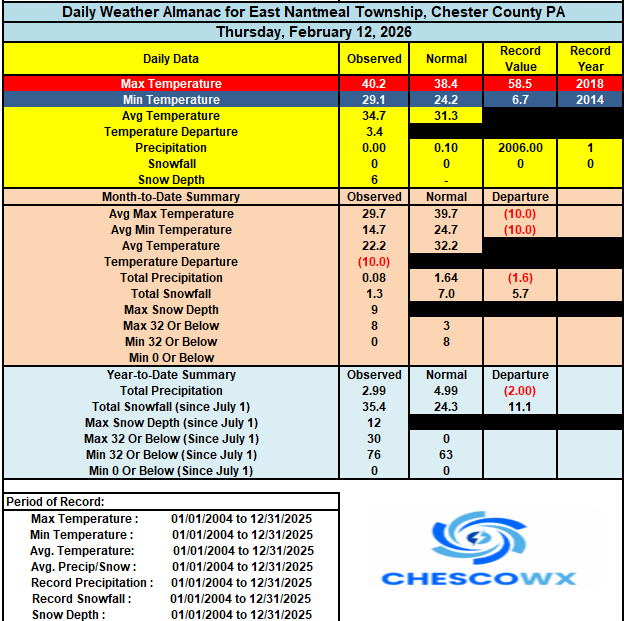
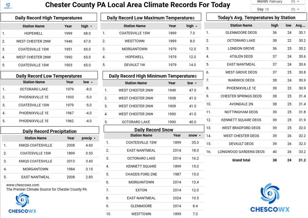
Sunny with highs near freezing today. We then turn a bit milder over the weekend with highs near average not too far from 40 degrees. A slight chance of some light snow by Sunday night before a nice warm-up toward the middle of next week. We will see highs well into the 40's. Rain chances increase again by Wednesday and we will trend colder again by next weekend. -
(002).thumb.png.6e3d9d46bca5fe41aab7a74871dd8af8.png)
E PA/NJ/DE Winter 2025-26 Obs/Discussion
ChescoWx replied to LVblizzard's topic in Philadelphia Region
Sunny with highs near freezing today. We then turn a bit milder over the weekend with highs near average not too far from 40 degrees. A slight chance of some light snow by Sunday night before a nice warm-up toward the middle of next week. We will see highs well into the 40's. Rain chances increase again by Wednesday and we will trend colder again by next weekend. -
Jealous, I've chased LES events there and its a wonderland... should be fun. Wonder how they statistically do in ninos up there?
-
That would absolutely be a wild card but I think its more likely the TPV is going to end up on the other side of the hemisphere
-
Yup...once you get into about mid February through mid March the swings can be pretty enormous. It's unlikely any one pattern regime truly dominates for more than several days just because of the changes which are going on within the hemisphere. In terms of temperatures and next week, I think its a very difficult signal. I think overall, the AO/NAO/PNA structure point towards more average to slightly above average...but that isn't a bad thing when talking about the potential for an increasingly active pattern. Some of our best snows and stretches come in that sort of regime.
-

Central PA Winter 25/26 Discussion and Obs
Jns2183 replied to MAG5035's topic in Upstate New York/Pennsylvania
I want to make it known just how rare these past 19 days have been. KMDT has had snow on the ground since 1/25. Adding up snow depths we get 111" or an average of 5.84"; but never more than 9". When looking at the past In the last 126 years of data, this specific "steady but deep" condition has only occurred in 4 winter seasons: 1905 1925 1961 1968 Usually to get to 19 days requires a big boy storm. This has been a throwback winter in a way. Sent from my SM-S731U using Tapatalk


