All Activity
- Past hour
-
-
One aspect I've noticed over the many years of guidance behavior ...and actually have use it/anticipated it at times, is that the general model ambit will flavor a pattern like that above, or its antithesis, with surprising coherence sometimes in time ranges of D11-15, only to then lose it. In fact, the interim runs as the days then click by, even attempting to reverse the signal in mangled forms and discontinuity from run to run. All but lost. But then the original signal ultimately came back ... say D5-7, just perhaps not as amplified as the original vision.
-
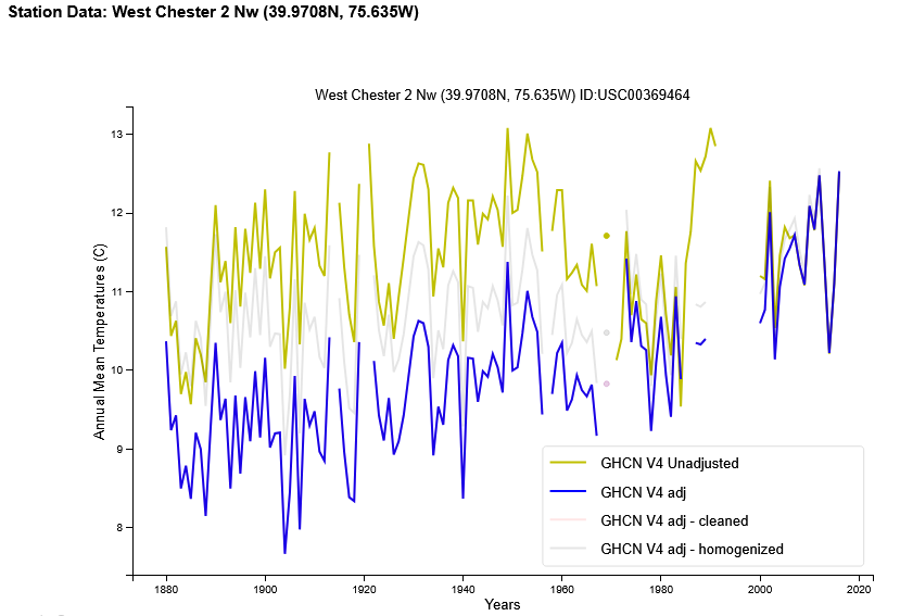
 Charlie so why again are all stations you mentioned Coatesville, West Chester and Phoenixville all clearly chilling the past and warming the current. See the raw vs adjusted for each below.
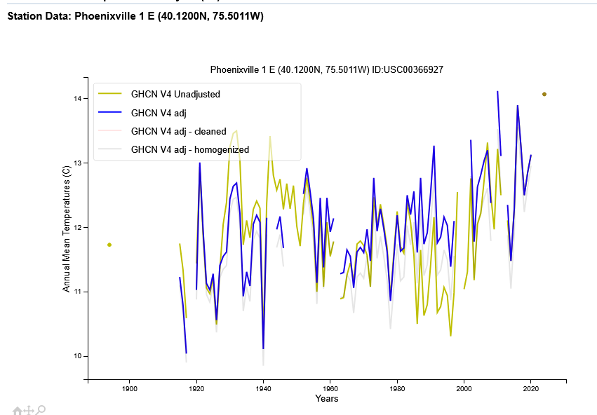

-
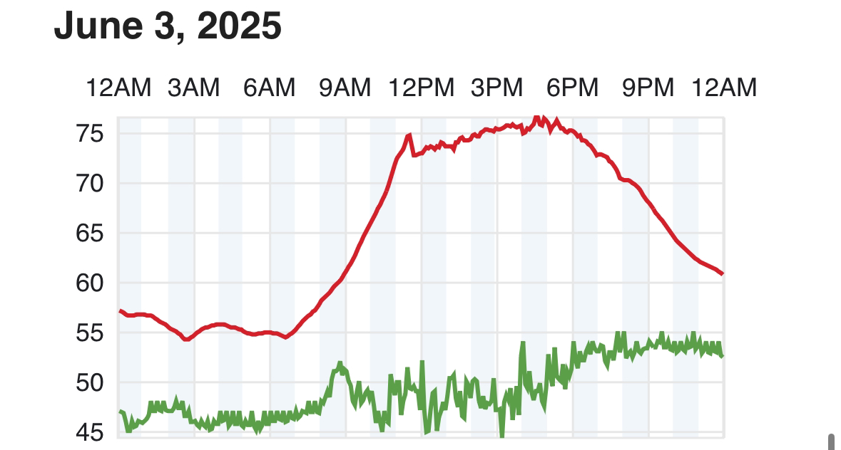
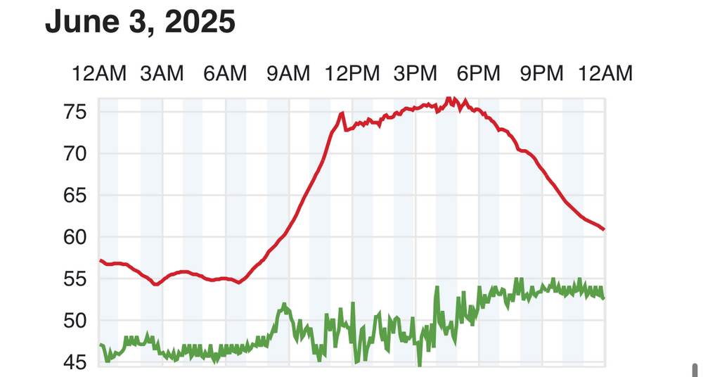
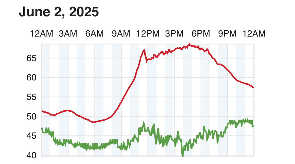
 why does his station drop at noon every day?
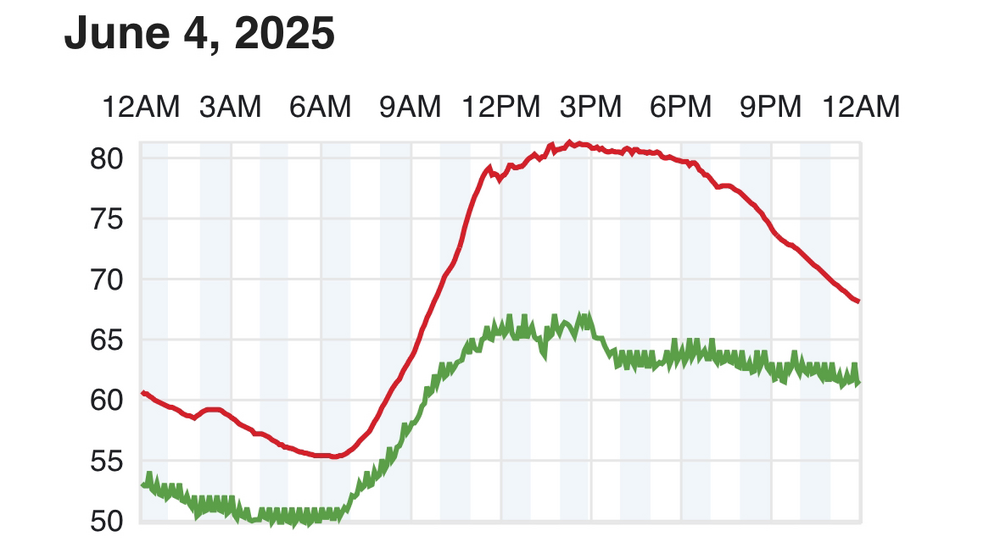
-

Chester County PA - Analytical Battle of Actual vs. Altered Climate Data
bdgwx replied to ChescoWx's topic in Climate Change
You've been telling me the problem is the act of making corrections or even just determining if there are biases, errors, or mistakes is fraudulent and should never be done under any circumstance. -
MDR region cool-might inhibit some tropical formation this year if that holds...
-
That is simpy an equal chance outlook... far from a forecast. The extended Euro and GFS models paint a normal to below month - not saying there won't be a warmer week in the mix.
-

2025-2026 ENSO
40/70 Benchmark replied to 40/70 Benchmark's topic in Weather Forecasting and Discussion
2014 is in a class of its own for QBO matches right now......its also a pretty damn good match for solar, too....so more reason to be skeptical of much arctic blocking. We are probably going to need to get it done on the Pacific side, which is what the CANSIPS does. That is also consistent with my very early idea, but extremely low confidence obviously. -
Still a vague signal for heat circa 11th -15th ... It's not as pretty in the guidance as 3 days ago, but the telecon spread offers correlation room for it, and there is some attempt - albeing weakly at presetnt - in the operational model versions to -PNAP that flow structure across the mid latitude continent. That's code for this kind of jet (tendency) ... If it fades, it fades ... but the signal's still there.
-
81/63
-
SST Anomaly
-
Not nearly as sunny as yesterday - i counted 0 clouds the majority of the day. Warmer start - slightly warmer 850 MB temps itll will be close the 90 degree mark - warm regardless. Wondwer how much breaks or clouds we have Sat - Sun.
-
Barrier islands in the mid 60s. Might be about as warm as they get since as the day goes on the seabreeze only strengthens.
-
Deep deep deep summer. Love it
-
People were concerned for rain happening like at all on the weekend but I have a different take ( seein' as anyone at all cares haha). I don't mind humid thundery forms of rain. It's the 55 degree shit spray constant shart out of ole Labrador's anus that grades at nerves for me. This doesn't appear to be of that ilk tomorrow and Saturday. Having a frontalysis stalled through the area with theta -e pooling under solar max sun is great cloud video op for one. But I dunno ...otherwise as a Met, I like actionable weather, and having CAPEy air amid a convergence zone can be fun lightning shows and interesting rain rate thunderstorms. It's also not likely to be raining all the time. All of which is happening in still mild to warm air.
-
79/65 ok it feels like summer now
-
could see some bangers around daybreak too
-
#pantstent

-
Sweated taking the puppy for a walk
-
80 off a low of 61. Maybe we hit 85 today? Very tricky being mid island now to figure out how hot we get. Still north of LIE but cooler than areas north of here
-
Pitchings been great. Bats still need to wake up.
-
Man what a day. This is what we are made for.
-
Looking like Saturday maybe not a washout and Sunday better chance for rain now?
-
Takes an extra hour to mix out there in the valley I think.