All Activity
- Past hour
-
partly sunny and 70 here
-
Wednesday/Thursday do look hot on most guidance. Time to install this weekend
-
URGENT - IMMEDIATE BROADCAST REQUESTED Tornado Watch Number 348 NWS Storm Prediction Center Norman OK 135 PM EDT Fri May 30 2025 The NWS Storm Prediction Center has issued a * Tornado Watch for portions of Northwest into Central North Carolina Western and Northern Virginia Southern and Eastern West Virginia * Effective this Friday afternoon and evening from 135 PM until 800 PM EDT. * Primary threats include... A couple tornadoes possible Scattered damaging wind gusts to 70 mph possible Isolated large hail events to 1.5 inches in diameter possible SUMMARY...Scattered thunderstorms are forecast to develop ahead of a surface low where enlarged hodographs and moist low levels will promote a mix of cells and bands of storms. The stronger storms will pose a risk for a couple of tornadoes, scattered damaging gusts, and isolated large hail. The tornado watch area is approximately along and 80 statute miles east and west of a line from 30 miles north northeast of Elkins WV to 20 miles southwest of Greensboro NC. For a complete depiction of the watch see the associated watch outline update (WOUS64 KWNS WOU8). PRECAUTIONARY/PREPAREDNESS ACTIONS... REMEMBER...A Tornado Watch means conditions are favorable for tornadoes and severe thunderstorms in and close to the watch area. Persons in these areas should be on the lookout for threatening weather conditions and listen for later statements and possible warnings. && OTHER WATCH INFORMATION...CONTINUE...WW 347... AVIATION...Tornadoes and a few severe thunderstorms with hail surface and aloft to 1.5 inches. Extreme turbulence and surface wind gusts to 60 knots. A few cumulonimbi with maximum tops to 500. Mean storm motion vector 25035. ...Smith
-
URGENT - IMMEDIATE BROADCAST REQUESTED Severe Thunderstorm Watch Number 347 NWS Storm Prediction Center Norman OK 1255 PM EDT Fri May 30 2025 The NWS Storm Prediction Center has issued a * Severe Thunderstorm Watch for portions of East-Central Alabama Northern into Central and Eastern Georgia Western North Carolina Western and Central South Carolina * Effective this Friday afternoon and evening from 1255 PM until 800 PM EDT. * Primary threats include... Widespread damaging wind gusts to 70 mph likely Isolated large hail events to 1.5 inches in diameter possible A tornado or two possible SUMMARY...A developing broken band of intensifying thunderstorms will quickly move across the Watch area this afternoon into the early evening. Severe gusts (60-70 mph) capable of wind damage will be the primary hazard. A brief tornado or two is possible in addition to an isolated risk for large hail. The severe thunderstorm watch area is approximately along and 115 statute miles east and west of a line from 35 miles east northeast of Hickory NC to 25 miles southeast of Columbus GA. For a complete depiction of the watch see the associated watch outline update (WOUS64 KWNS WOU7). PRECAUTIONARY/PREPAREDNESS ACTIONS... REMEMBER...A Severe Thunderstorm Watch means conditions are favorable for severe thunderstorms in and close to the watch area. Persons in these areas should be on the lookout for threatening weather conditions and listen for later statements and possible warnings. Severe thunderstorms can and occasionally do produce tornadoes. && AVIATION...A few severe thunderstorms with hail surface and aloft to 1.5 inches. Extreme turbulence and surface wind gusts to 60 knots. A few cumulonimbi with maximum tops to 500. Mean storm motion vector 27045. ...Smith
-
its a nursery web spider..very common..and not a threat to you (except in your upcoming nightmares).
-
yeah, distinct mugginess to the air for first time in a long time.
-
If the nocturnal inversion kicks in then it's a moot point. But any leftover precipitation could act as a conduit for the wind.
-
Humid and 79 here. Storms building to my Wnw. Getting dark that way.
-
Clouds were rolling in at 7 for me. No rain just breezy.
-
- 803 replies
-
- 1
-

-
- severe
- thunderstorms
- (and 2 more)
-
Darkness has warshed over this dude. Darker'n a black steer's tuchus on a moonless prairie night.
-
The sun is back !! It's just here for 30 minutes gone for 30 minutes and back again.
-
Tornado Watch up for i81 corridor for now
- 803 replies
-
- 1
-

-
- severe
- thunderstorms
- (and 2 more)
-
We whistle
-
16z HRRR looks to bring in a line of supercells through the i95 corridor between 6pm and 9pm... then rotates in a complex of heavy rain after midnight for N VA/DC/MD
- 803 replies
-
- 2
-
-
- severe
- thunderstorms
- (and 2 more)
-
Up to 76 here but still mainly cloudy skies with some breaks the clearing to full sunshine is looking less likely. Could push 80 in the warm spots
-
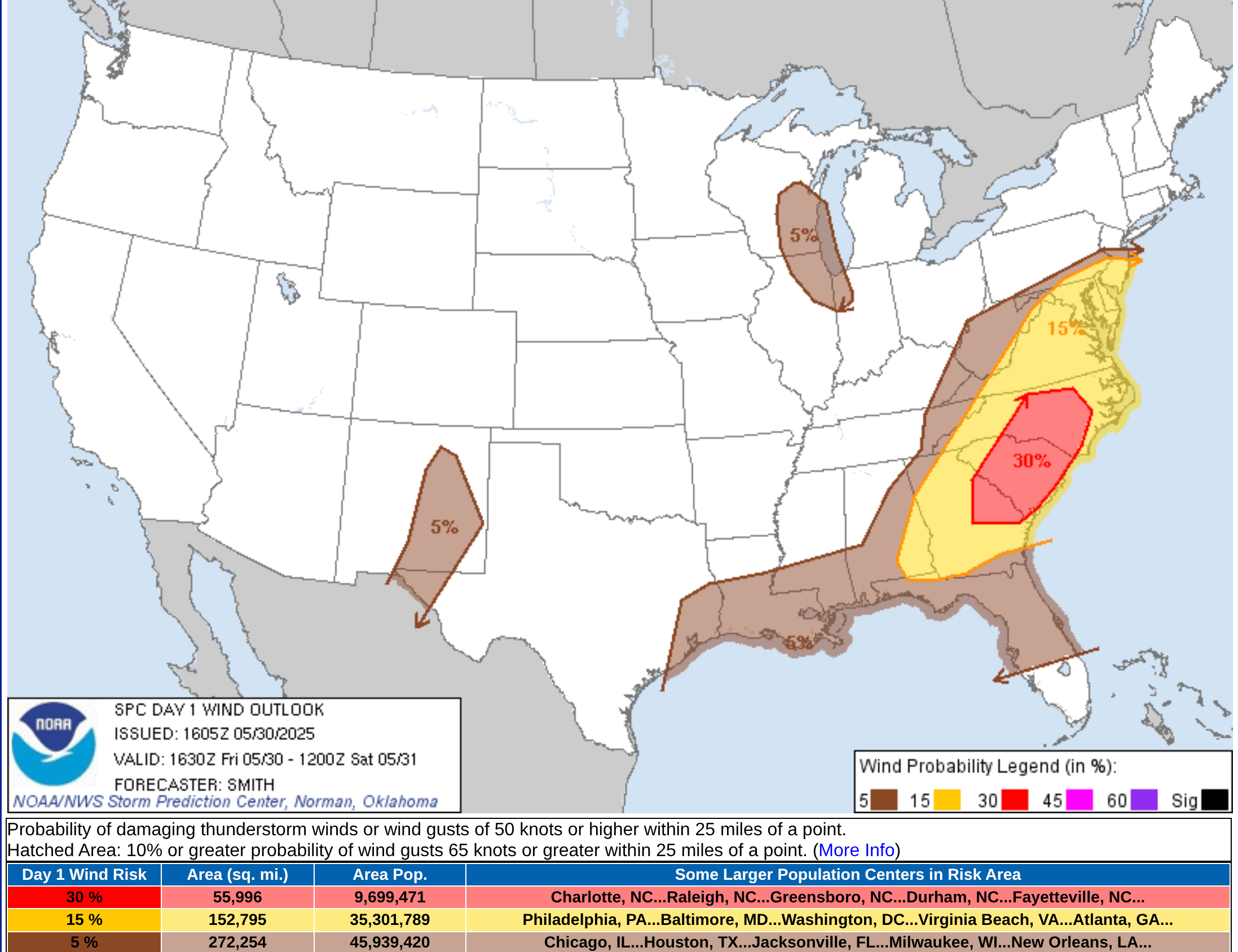
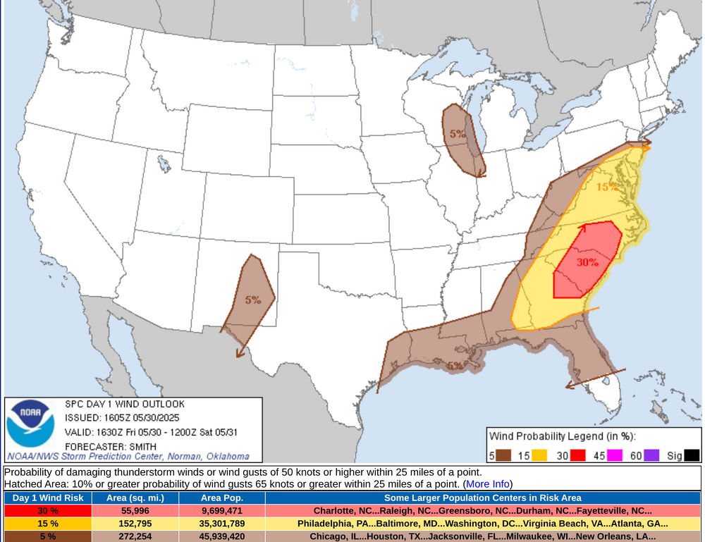
Charlotte, Raleigh/Durham, Greensboro, Columbia, Augusta, Savannah have an enhanced damaging wind threat today.
-
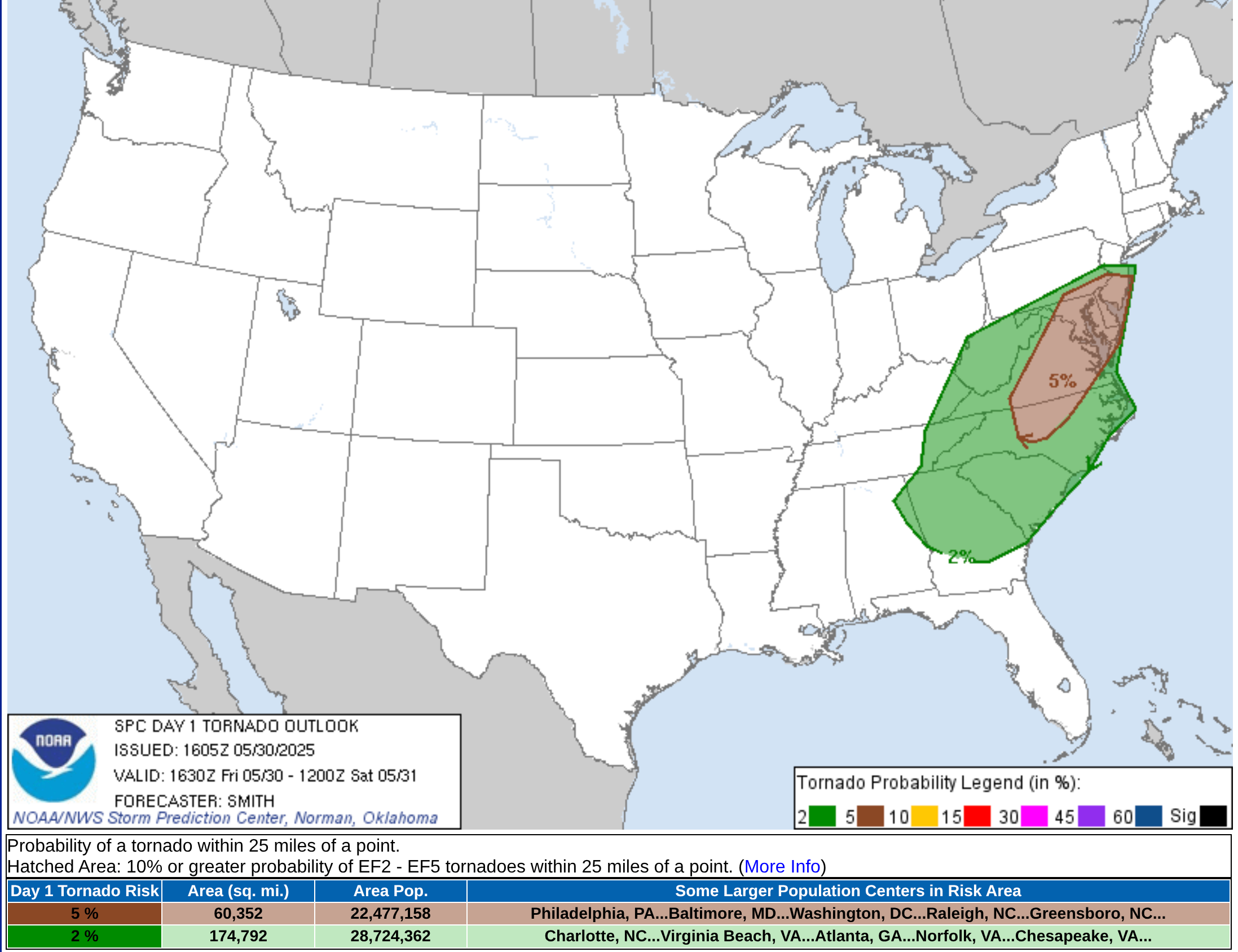
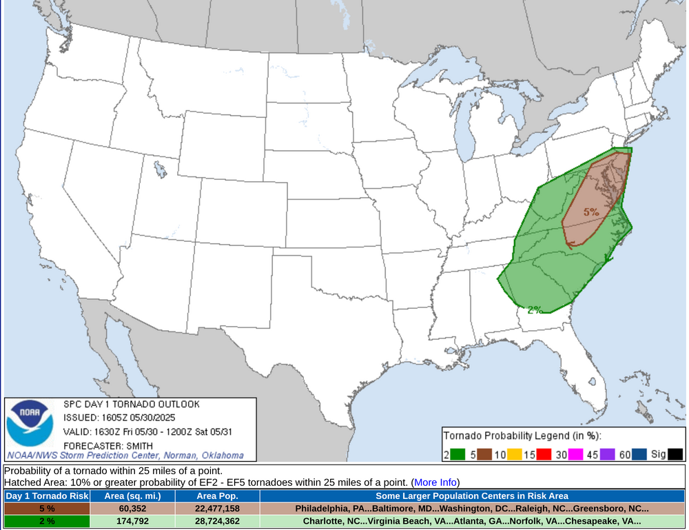
Raleigh/Durham, Richmond, Washington, and Baltimore might see more of threat of tornadic supercells or QLCS tornadic development
-
- 803 replies
-
- 2
-
-
-
- severe
- thunderstorms
- (and 2 more)
- Today
-
Tornado Watch coming soon for western part of the CWA
- 803 replies
-
- 1
-
-
- severe
- thunderstorms
- (and 2 more)
-
Looking back at this, I'm not sure there was ever much support for such a feature really and not sure it synoptically made sense.
-
It’s definitely worth watching. Once the trough axis passes, winds just above the surface shift to northwest, and the speeds rocket up (50+ kt) just above the ground. The question always is whether those speeds can be mixed downward. Some of the guidance shows an additional round of showers after midnight with some very weak low-level instability. Can that get it done? Not sure, but it could.
-
yeah it's coming and going lol
-
Seems to be the case,yup.
-
Second half of the week is shaping up to be on the hot/humid side. The signal for that cut-off low is fading and we are going to turn the flow WSW or SW with the front approaching and eventually stalling somewhere within the region. Going to be lots of mid-to-upper 80's to lower 90's in the torch spots if we mix fully.