All Activity
- Past hour
-

Central PA Winter 25/26 Discussion and Obs
Itstrainingtime replied to MAG5035's topic in Upstate New York/Pennsylvania
MU says it's here between 6-8pm. -
mPING reports of all snow in southern Franklin County. Encouraging.
-
.thumb.jpeg.f5c6ba9d911ec96b3b124f8606aee58e.jpeg)
Moderate snowfall 12/14/2025 WWA up for most of the area
TJW014 replied to WeatherGeek2025's topic in New York City Metro
BS. It's a max of 41 per the Weatherflow stations along the Barnegat and LBI barrier islands. Car thermometers are terrible. They'll be reading 105 when it's in the low 99s -
41 and cloudy here but dew is 22.
-
Just pulled the snow shovel out, and you know what that means, that means nothing because jinxes aren't real. Glad this has evolved into much wider event! It was agonizing tracking a narrow band. It's fun seeing mby be in or near the jackpot. In honesty, and this is not a meteorological opinion, usually the highest totals will wind up at least a bit NW of here, even when we are favored, will not be surprised at all. Let's roll!!!
-

Pittsburgh/Western PA WINTER ‘25/‘26
MikeB_01 replied to Burghblizz's topic in Upstate New York/Pennsylvania
I’m going to head out here pretty soon to get an update. From my window looks to be maybe 1.5”. But it’s an awesome look outside. Can’t wait for tonight when the neighborhood turns on the lights . -
What’s the true timing of this?
-

12/14: Sunday funday? Will the south win again?
SnowenOutThere replied to TSSN+'s topic in Mid Atlantic
I got an English (online) 8am Tuesday and a chemistry final (in person) 7pm Tuesday but otherwise I'm free. I've decided Ill make a list of study topics for chemistry and if I finish them it'll be a 10pm-midnight car adventure for me! -

Moderate snowfall 12/14/2025 WWA up for most of the area
SnoSki14 replied to WeatherGeek2025's topic in New York City Metro
38/26 in Somerset. Perfectly fine for snow. Advisory bumped us up to 3-5" -
 37/27f here. Not too bad of a starting point. Also temps should start dropping slowly since sunset is approaching
 -

Central PA Winter 25/26 Discussion and Obs
Blizzard of 93 replied to MAG5035's topic in Upstate New York/Pennsylvania
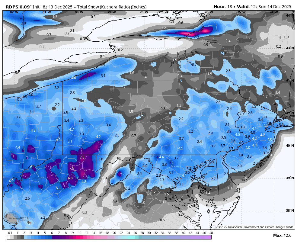
18z RGEM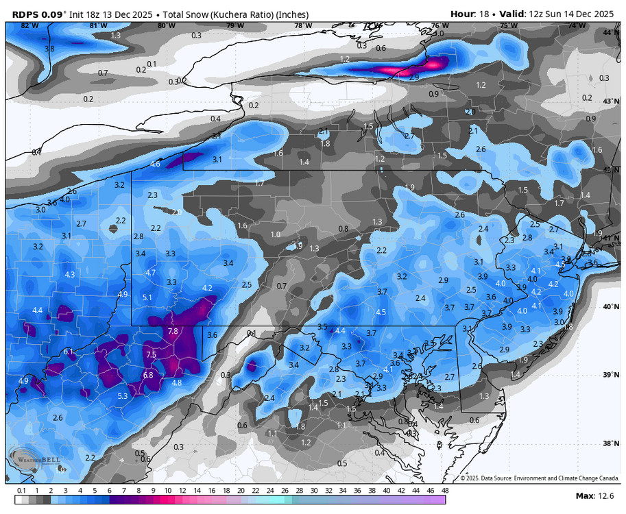
-

12/14: Sunday funday? Will the south win again?
NorthArlington101 replied to TSSN+'s topic in Mid Atlantic
I’d probably make a 1.5 hour drive home for a 2-3” event and free lodging & food if I wouldn’t need to turn around just a few hours later. But this isn’t a big dog. You’d be okay to stay put. If you’ve got no reason to be in Cville any longer for the semester, I’d rally back for sure. -
 4pm NWS Obs all showing westerly winds in the city and at Newark. CP down to 39 with a DP of 25
 -
Road cams show snow wear of Cumberland already
-

December 2025 Short/Medium Range Forecast Thread
Golf757075 replied to John1122's topic in Tennessee Valley
I hope it gets resolved soon. Apparently things aren't in sync where we want them to be with kelvin waves/ rosby waves etc. Larry Cosgrove is good, but he sometimes hypes things too much. He has much experience doing weather for a long time. He called for a warm December and cold mid January through March. I hope he is correct. -

December 14th - Snow showers or Plowable snow?
moneypitmike replied to Sey-Mour Snow's topic in New England
Tonight I'm in our temporary PVD rental. I'll be heading up to Pit2 (Maine) tomorrow. On Friday, we'll have a new Pi1 in Mattapoisett. At that point, I'll never speak of PVD again. Most of my time this last few months has been in Bath. The new house will require a lot of work. So barring getting a job in Maine, I'll be spending a lot of time with the new fixer-upper. I'll hightail it to Maine whenever there's a storm coming----hopefully snow blowing bill be a frequent excuse to get up there. -
I just saw my Mountain point forecast for tomorrow at 7pm. 1 degree and 35 mph winds with gusts to 45. Geez. Wind chill -25. That's gonna bite.
-

December 11th-14th Double Banger Clippers
trippinjedi replied to Jackstraw's topic in Lakes/Ohio Valley
Got almost 2" here in Zanesville. Local is calling for 4-7" total accumulation. -

Moderate snowfall 12/14/2025 WWA up for most of the area
wthrmn654 replied to WeatherGeek2025's topic in New York City Metro
Yep looking at airport metar there from south to more west direction now -
.thumb.jpg.6a4895b2a43f87359e4e7d04a6fa0d14.jpg)
Central PA Winter 25/26 Discussion and Obs
Yardstickgozinya replied to MAG5035's topic in Upstate New York/Pennsylvania
Well, hopefully someone filled you in. @Itstrainingtime is right and it's not worth bringing up on this glorious day. -
12/14: Sunday funday? Will the south win again?
SnowenOutThere replied to TSSN+'s topic in Mid Atlantic
Oh man, I'm getting suckered into this one after looking over the latest models. @NorthArlington101 I know you bounced between nova and Cville so whats your advice -
12/14: Sunday funday? Will the south win again?
NorthArlington101 replied to TSSN+'s topic in Mid Atlantic
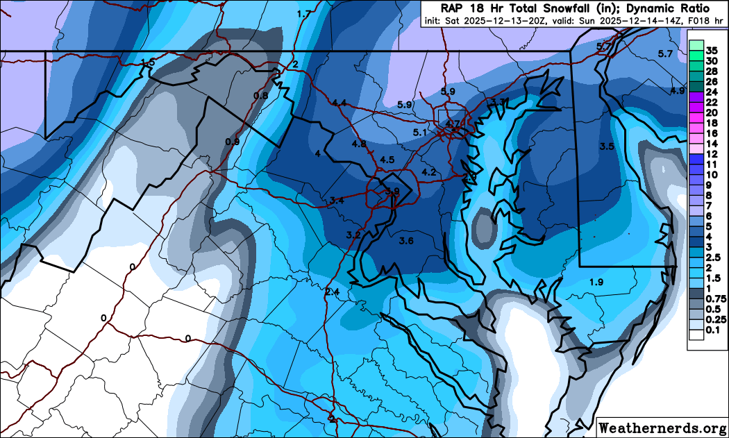
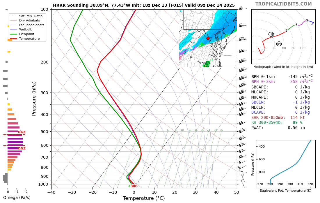
On today’s edition of It’s the RAP, but…
-
Probably 11-12:1 ratios
-
12/14: Sunday funday? Will the south win again?
SnowenOutThere replied to TSSN+'s topic in Mid Atlantic
I mean this seems pretty legit look at that saturation and lift. Would just be dumping dendrites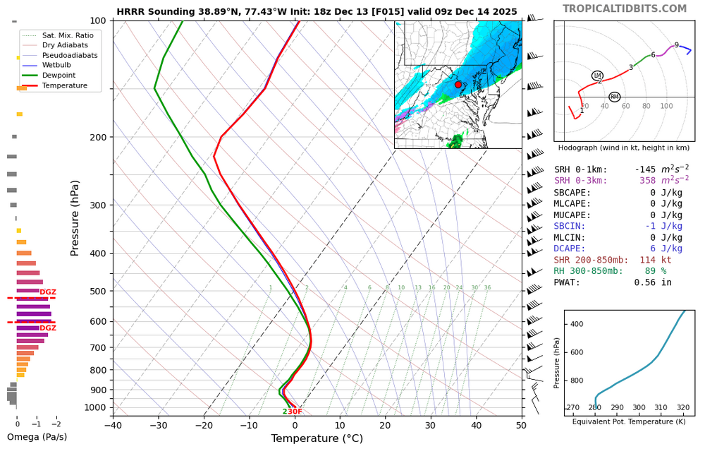
-
HRRR RAP NAM and Canadian Mesos all on board in the very short term. Temps a tad lower than expected. All systems go!